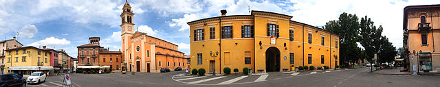
Луганьяно-Валь-д'Арда (Lugagnano Val d'Arda, Lugagnano Val d'Arda)
.svg)
- коммуна Италии
 Hiking in Луганьяно-Валь-д'Арда
Lugagnano Val d'Arda is a charming village located in the Piacenza province of Emilia-Romagna, Italy. The surrounding area offers a mix of scenic landscapes, rolling hills, and rural charm, making it an attractive destination for hiking enthusiasts. Here are some highlights and tips for hiking in this area:
Trails and Terrain
-
Natural Landscapes: The region features picturesque views of the Arda River valley, vineyards, and vast countryside. The trails often meander through forests, olive groves, and fields.
-
Diverse Hiking Options: There are various trails suited for different skill levels, ranging from easy walks suitable for families to more challenging routes meant for seasoned hikers.
-
Sentiero degli Artisti: This is a notable trail in the region that you might encounter, focusing on nature and art. The path is often marked with local artists' installations, enhancing your hiking experience.
Key Locations
- Castello di Lugagnano: Adding historical interest to your hike, this castle is perched on a hill and provides a great spot for a break and some stunning panoramic views.
- Local Vineyards: Don't miss the chance to stroll through local vineyards, where you can appreciate the winemaking culture of the region.
Seasonal Considerations
- Spring and Fall: The best times to hike in Lugagnano Val d'Arda are during late spring and early autumn when the weather is mild, and the landscapes are particularly vibrant.
- Summer: While summer offers beautiful views, be sure to start your hikes early in the day to avoid the midday heat.
- Winter: Hiking can be done but be cautious of wet or icy conditions; it's advisable to check the weather beforehand.
Preparation and Tips
- Footwear: Wear sturdy, comfortable hiking boots with good traction.
- Supplies: Bring enough water, snacks, and a basic first-aid kit. Some trails may lack facilities, so be self-sufficient.
- Navigation: Consider downloading trail maps or apps, as well-marked trails can vary in visibility. Local tourist offices may provide maps and additional information.
Local Culture
- Engaging with the local culture can greatly enhance your hiking experience. Take time to visit local farms, enjoy traditional Emiliano-Romagnolo cuisine in local trattorias, and participate in regional festivities if your visit coincides with any.
Lugagnano Val d'Arda and its surroundings provide a wonderful backdrop for both leisurely and challenging hikes, making it a rewarding destination for hikers of all levels. Happy hiking!
- Страна:

- Почтовый код: 29018
- Телефонный код: 0523
- Код автомобильного номера: PC
- Координаты: 44° 49' 0" N, 9° 49' 0" E


- GPS треки (wikiloc): [Ссылка]
- Высота над уровнем моря: 229 м m
- Площадь: 54.4 кв.км
- Население: 3976
- Веб сайт: http://www.comune.lugagnano.pc.it
- Википедия русская: wiki(ru)
- Википедия английская: wiki(en)
- Википедия национальная: wiki(it)
- Хранилище Wikidata: Wikidata: Q102807
- Катеория в википедии: [Ссылка]
- код Freebase: [/m/0gkcy5]
- код GeoNames: Альт: [6538414]
- код VIAF: Альт: [235658419]
- ID отношения в OpenStreetMap: [43618]
- место в MusicBrainz: [6a1fdcfb-eb8c-45dd-b387-9ff759e22fd6]
- WOEID: [717482]
- UN/LOCODE: [ITLUV]
- код Trismegistos: [31908]
- код ISTAT: 033026
- кадастровый код Италии: E726
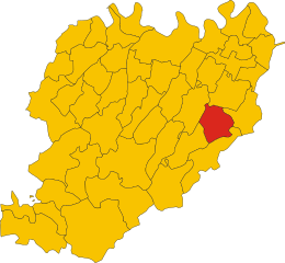
Граничит с регионами:

Карпането-Пьачентино
- коммуна Италии
Hiking in Карпането-Пьачентино
Carpaneto Piacentino is a charming town located in the Piacenza province of Emilia-Romagna, Italy. It is surrounded by beautiful landscapes, rolling hills, and vineyards, making it a delightful destination for hiking enthusiasts. Here are some highlights to consider if you're planning a hiking trip in and around Carpaneto Piacentino:...
- Страна:
- Почтовый код: 29013
- Телефонный код: 0523
- Код автомобильного номера: PC
- Координаты: 44° 55' 0" N, 9° 47' 0" E
- GPS треки (wikiloc): [Ссылка]
- Высота над уровнем моря: 400 м m
- Площадь: 63.08 кв.км
- Население: 7733
- Веб сайт: [Ссылка]
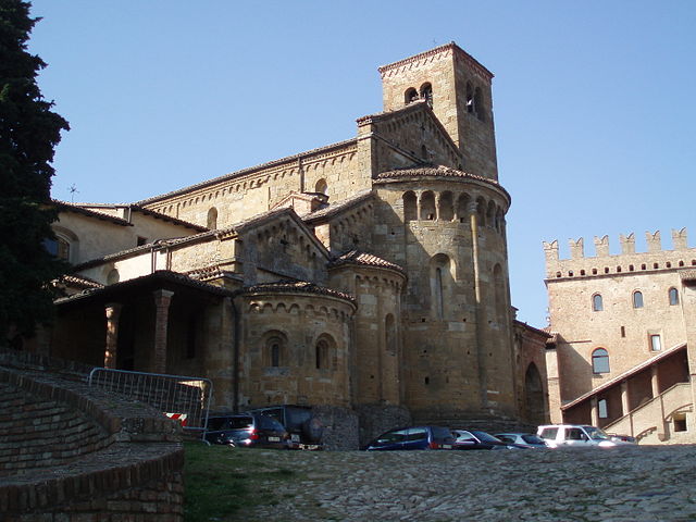
Кастелл'Аркуато
- коммуна Италии
Hiking in Кастелл'Аркуато
Castell'Arquato is a picturesque medieval village located in the Emilia-Romagna region of Italy, surrounded by rolling hills and stunning landscapes, making it a fantastic destination for hiking enthusiasts. The area around Castell'Arquato offers a variety of hiking trails that cater to different skill levels, from easy walks suitable for families to more challenging routes for experienced hikers....
- Страна:
- Почтовый код: 29014
- Телефонный код: 0523
- Код автомобильного номера: PC
- Координаты: 44° 51' 0" N, 9° 52' 0" E
- GPS треки (wikiloc): [Ссылка]
- Высота над уровнем моря: 224 м m
- Площадь: 52.75 кв.км
- Население: 4621
- Веб сайт: [Ссылка]


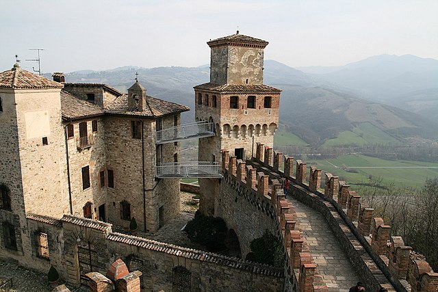
Гроппарелло
- коммуна Италии
Hiking in Гроппарелло
Gropparello is a picturesque area located in the Emilia-Romagna region of Italy, known for its beautiful landscapes, historical sites, and outdoor activities, including hiking. The surroundings are characterized by rolling hills, dense forests, and stunning views, making it an ideal spot for nature lovers and hiking enthusiasts....
- Страна:
- Почтовый код: 29025
- Телефонный код: 0523
- Код автомобильного номера: PC
- Координаты: 44° 50' 0" N, 9° 44' 0" E
- GPS треки (wikiloc): [Ссылка]
- Высота над уровнем моря: 355 м m
- Площадь: 56.33 кв.км
- Население: 2268
- Веб сайт: [Ссылка]
Морфассо
- коммуна Италии
Hiking in Морфассо
Morfasso is a charming village located in the Emilia-Romagna region of Italy, surrounded by picturesque landscapes, forests, and hills. It’s an excellent destination for hiking enthusiasts, offering a variety of trails that cater to different skill levels, from leisurely walks to more challenging treks....
- Страна:
- Почтовый код: 29020
- Телефонный код: 0523
- Код автомобильного номера: PC
- Координаты: 44° 43' 0" N, 9° 42' 0" E
- GPS треки (wikiloc): [Ссылка]
- Высота над уровнем моря: 631 м m
- Площадь: 83.93 кв.км
- Население: 972
- Веб сайт: [Ссылка]

Вернаска
- коммуна Италии
Hiking in Вернаска
Vernasca is a small town in the Emilia-Romagna region of Italy, located within the picturesque landscape of the Apennines. It offers a range of hiking opportunities for those looking to explore the natural beauty of the area....
- Страна:
- Почтовый код: 29010
- Телефонный код: 0523
- Код автомобильного номера: PC
- Координаты: 44° 48' 0" N, 9° 50' 0" E
- GPS треки (wikiloc): [Ссылка]
- Высота над уровнем моря: 457 м m
- Площадь: 72.57 кв.км
- Население: 2079
- Веб сайт: [Ссылка]