Лурнфельд (Lurnfeld, Lurnfeld)
 Hiking in Лурнфельд
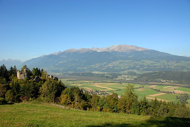
Lurnfeld, located in the scenic region of Carinthia, Austria, offers a fantastic range of hiking opportunities for all skill levels. Nestled between the majestic mountains and lush valleys, this area is known for its stunning landscapes, diverse flora and fauna, and well-maintained hiking trails. Here are some highlights for hiking in Lurnfeld:
Trails:
-
Difficulty Levels: There are trails suitable for beginners, intermediate hikers, and experienced mountaineers. You can find easy walking paths along the river or more challenging ascents into the mountains.
-
Scenic Routes: Many trails provide breathtaking views of the surrounding peaks, including the majestic peaks of the Hohe Tauern National Park, as well as opportunities to experience the idyllic countryside.
-
Duration and Length: Hikes can vary in duration from short walks of 1-2 hours to full-day hikes that may cover several kilometers with significant elevation gains.
Points of Interest:
- Local Flora and Fauna: Depending on the season, hikers can enjoy blooming wildflowers in spring and summer or the colorful foliage in autumn.
- Cultural Landmarks: Some trails may lead you to historical sites, quaint villages, or traditional Alpine huts where you can savor local cuisine.
- Informational Signage: Many trails have markers and signage that provide information on the local ecology, geology, and culture.
Best Times to Hike:
- Spring to Fall: The best hiking season is typically from late spring to early fall (May to October) when the weather is more stable, and the trails are usually accessible.
- Winter Hiking: In winter, some trails are suitable for snowshoeing or winter hiking, allowing you to experience the serene beauty of a snow-covered landscape.
Preparation Tips:
- Gear: Make sure to wear appropriate hiking footwear and clothing. Weather can change quickly in the mountains, so it's advisable to dress in layers and carry a rain jacket.
- Maps and Navigation: Always carry a map of the area or use hiking apps for navigation, as some areas may have limited signage.
- Safety: Inform someone about your hiking plans and expected return time, especially if you are venturing on longer or more remote trails.
Whether you're looking for a light stroll or a challenging hike, Lurnfeld has something to offer every outdoor enthusiast. Enjoy your trek and stay safe!
- Страна:

- Телефонный код: 04769
- Код автомобильного номера: SP
- Координаты: 46° 50' 0" N, 13° 22' 0" E


- GPS треки (wikiloc): [Ссылка]
- Высота над уровнем моря: 557 м m
- Площадь: 33.02 кв.км
- Население: 2599
- Веб сайт: http://www.lurnfeld.at
- Википедия русская: wiki(ru)
- Википедия английская: wiki(en)
- Википедия национальная: wiki(de)
- Хранилище Wikidata: Wikidata: Q572166
- Галерея изображений в википедии: [Ссылка]
- Катеория в википедии: [Ссылка]
- код Freebase: [/m/02qrzvx]
- код GeoNames: Альт: [7872795]
- код VIAF: Альт: [235507665]
- код австрийского муниципалитета: [20643]
Граничит с регионами:
Бальдрамсдорф
Hiking in Бальдрамсдорф
Baldramsdorf is a picturesque village located in the Carinthia region of Austria, surrounded by the stunning landscapes of the Alps. It offers a variety of hiking opportunities suitable for all skill levels, making it a great destination for outdoor enthusiasts....
- Страна:
- Почтовый код: 9805
- Телефонный код: 0 47 62
- Код автомобильного номера: SP
- Координаты: 46° 48' 4" N, 13° 27' 12" E
- GPS треки (wikiloc): [Ссылка]
- Высота над уровнем моря: 584 м m
- Площадь: 37.95 кв.км
- Население: 1866
- Веб сайт: [Ссылка]

Заксенбург
Hiking in Заксенбург
Sachsenburg, located in the German state of Saxony, offers a variety of hiking opportunities for outdoor enthusiasts. The region is characterized by its beautiful landscapes, rich history, and diverse flora and fauna, making it an excellent destination for both casual hikers and experienced trekkers....
- Страна:
- Почтовый код: 9751
- Телефонный код: 04769
- Код автомобильного номера: SP
- Координаты: 46° 49' 45" N, 13° 21' 18" E
- GPS треки (wikiloc): [Ссылка]
- Высота над уровнем моря: 557 м m
- Площадь: 42.57 кв.км
- Население: 1289
- Веб сайт: [Ссылка]
Лендорф
Hiking in Лендорф
Lendorf, located in Austria, is a beautiful destination for hiking enthusiasts. Nestled in the Carinthia region, it offers a stunning landscape characterized by rolling hills, lush forests, and panoramic views of the surrounding mountains. Here are some key points to consider when hiking in Lendorf:...
- Страна:
- Почтовый код: 9811
- Телефонный код: 0 47 62
- Код автомобильного номера: SP
- Координаты: 46° 50' 0" N, 13° 25' 0" E
- GPS треки (wikiloc): [Ссылка]
- Высота над уровнем моря: 584 м m
- Площадь: 34.3 кв.км
- Население: 1712
- Веб сайт: [Ссылка]

Мюльдорф
Hiking in Мюльдорф
Mühldorf in Carinthia, Austria, is a beautiful location for hiking enthusiasts, offering a mix of scenic landscapes, well-maintained trails, and a rich natural environment. Here are some highlights you can expect when hiking in this area:...
- Страна:
- Почтовый код: 9814
- Телефонный код: 0 47 69
- Код автомобильного номера: SP
- Координаты: 46° 51' 27" N, 13° 21' 7" E
- GPS треки (wikiloc): [Ссылка]
- Высота над уровнем моря: 613 м m
- Площадь: 24.34 кв.км
- Население: 1007
- Веб сайт: [Ссылка]