Магдаленсберг (Magdalensberg, Magdalensberg)
 Hiking in Магдаленсберг
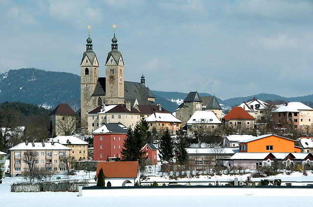
Magdalensberg is a beautiful hiking destination located in Carinthia, Austria, known for its stunning landscapes, rich history, and diverse flora and fauna. The mountain offers a variety of hiking trails suitable for different skill levels, making it accessible for both casual walkers and more experienced hikers.
Key Highlights of Hiking in Magdalensberg:
-
Scenic Views: The summit of Magdalensberg offers panoramic views of the surrounding Carinthian landscape, including the picturesque city of Klagenfurt and the nearby lakes.
-
Historical Significance: This area is steeped in history, featuring remnants of ancient Roman settlements and Celtic fortifications. Exploring these sites can add an educational element to your hike.
-
Flora and Fauna: The region is home to a diverse range of plant species and wildlife, making it an excellent spot for nature enthusiasts. You might encounter various wildflowers, birds, and even deer along the trails.
-
Trail Options: There are several well-marked trails on Magdalensberg catering to different fitness levels. Beginner-friendly paths are available, as well as more challenging routes for experienced hikers.
-
Accessibility: Magdalensberg can be easily reached from nearby towns, and there are often public transport options available for those wishing to hike without needing a car.
-
Seasonal Hiking: Different times of the year offer unique experiences. Spring and summer showcase blooming wildflowers, while autumn provides stunning foliage. Winter hiking is also available, but it's important to check conditions and be prepared for snow.
Recommendations:
- Preparation: Always check the weather forecast, wear appropriate footwear, and carry sufficient water and snacks for your hike.
- Guided Tours: If you’re new to the area, consider joining a guided tour to gain local insights and ensure a safe experience.
- Respect Nature: Follow the Leave No Trace principles to preserve the natural beauty of the area for future visitors.
Hiking in Magdalensberg is not just about the exercise; it's about immersing yourself in the beautiful landscape and the rich cultural heritage of the region. Enjoy your adventure!
- Страна:

- Почтовый код: 9064
- Телефонный код: 0 42 24
- Код автомобильного номера: KL
- Координаты: 46° 42' 4" N, 14° 25' 52" E


- GPS треки (wikiloc): [Ссылка]
- Высота над уровнем моря: 450 м m
- Площадь: 42.89 кв.км
- Население: 3455
- Веб сайт: http://www.magdalensberg.gv.at/
- Википедия русская: wiki(ru)
- Википедия английская: wiki(en)
- Википедия национальная: wiki(de)
- Хранилище Wikidata: Wikidata: Q662478
- Галерея изображений в википедии: [Ссылка]
- Катеория в википедии: [Ссылка]
- код Freebase: [/m/02qqb3h]
- код GeoNames: Альт: [7871639]
- код VIAF: Альт: [233677616]
- идентификатор местоположения ArchINFORM: [11193]
- код тезауруса PACTOLS: [pcrtaSJuvn2Dmi]
- код австрийского муниципалитета: [20442]
Граничит с регионами:


Клагенфурт
- город в Австрии
Hiking in Клагенфурт
Klagenfurt, located in Austria's Carinthia region, offers a stunning backdrop for hiking enthusiasts. Nestled near the eastern shore of Lake Wörthersee and surrounded by scenic mountain ranges, it boasts a variety of hiking trails suitable for different experience levels....
- Страна:
- Почтовый код: 9201; 9073; 9065; 9063; 9061; 9020
- Телефонный код: 0463
- Код автомобильного номера: K
- Координаты: 46° 37' 0" N, 14° 18' 0" E
- GPS треки (wikiloc): [Ссылка]
- Высота над уровнем моря: 446 м m
- Площадь: 120 кв.км
- Население: 100369
- Веб сайт: [Ссылка]

Санкт-Файт-ан-дер-Глан
- город и городская община в Австрии
Hiking in Санкт-Файт-ан-дер-Глан
Sankt Veit an der Glan, located in Austria's Carinthia region, is an excellent destination for hiking enthusiasts. The area boasts a stunning natural landscape, with rolling hills, lush valleys, and nearby mountains, making it ideal for a variety of hiking experiences suitable for different skill levels....
- Страна:
- Почтовый код: 9300
- Телефонный код: 04212
- Код автомобильного номера: SV
- Координаты: 46° 46' 0" N, 14° 21' 37" E
- GPS треки (wikiloc): [Ссылка]
- Высота над уровнем моря: 482 м m
- Площадь: 50.73 кв.км
- Население: 12547
- Веб сайт: [Ссылка]

Брюккль
- политическая община в Австрии
Hiking in Брюккль
Brückl is a charming town in Austria, located in the Carinthia region. It offers a variety of hiking opportunities that cater to different skill levels and interests. Here are some highlights and tips for hiking in and around Brückl:...
- Страна:
- Почтовый код: 9371
- Телефонный код: 04214
- Код автомобильного номера: SV
- Координаты: 46° 45' 11" N, 14° 32' 9" E
- GPS треки (wikiloc): [Ссылка]
- Высота над уровнем моря: 510 м m
- Площадь: 46.62 кв.км
- Население: 2717
- Веб сайт: [Ссылка]

Санкт-Георген-ам-Ленгзе
- политическая община в Австрии
Hiking in Санкт-Георген-ам-Ленгзе
Sankt Georgen am Längsee is a charming destination for hikers, situated in the Carinthia region of Austria. The area is known for its beautiful landscapes, lush forests, and the picturesque Längsee, a serene lake that provides a stunning backdrop for outdoor activities....
- Страна:
- Телефонный код: 0 42 13
- Код автомобильного номера: SV
- Координаты: 46° 46' 48" N, 14° 25' 55" E
- GPS треки (wikiloc): [Ссылка]
- Высота над уровнем моря: 537 м m
- Площадь: 69.8 кв.км
- Население: 3648
- Веб сайт: [Ссылка]
Поггерсдорф
Hiking in Поггерсдорф
Poggersdorf is a charming area located in Carinthia, Austria, known for its beautiful landscapes and outdoor recreational opportunities. While not as widely known as some other hiking destinations in Austria, Poggersdorf offers a peaceful and scenic environment for hiking enthusiasts....
- Страна:
- Почтовый код: 9130
- Телефонный код: 0 42 24
- Код автомобильного номера: KL
- Координаты: 46° 39' 0" N, 14° 27' 0" E
- GPS треки (wikiloc): [Ссылка]
- Высота над уровнем моря: 465 м m
- Площадь: 30.74 кв.км
- Население: 3193
- Веб сайт: [Ссылка]
Мариа-Заль
Hiking in Мариа-Заль
Maria Saal is a picturesque area located in Carinthia, Austria, known for its rich history and stunning natural landscapes. The region offers a variety of hiking opportunities suitable for all skill levels, with trails that allow hikers to explore the beautiful countryside, forests, and hills surrounding the village....
- Страна:
- Почтовый код: 9063
- Телефонный код: 04223
- Код автомобильного номера: KL
- Координаты: 46° 40' 51" N, 14° 20' 55" E
- GPS треки (wikiloc): [Ссылка]
- Высота над уровнем моря: 505 м m
- Площадь: 34.84 кв.км
- Население: 3835
- Веб сайт: [Ссылка]