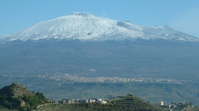
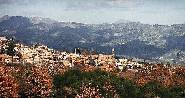
Малетто (Maletto, Maletto)
- коммуна в Италии
Maletto is a charming town located in the province of Catania in Sicily, Italy. Its position in the Nebrodi National Park makes it a wonderful destination for hiking enthusiasts. Here are some highlights about hiking in and around Maletto:
Scenic Trails
-
Nebrodi National Park: The park boasts a network of trails that lead through dense forests, rolling hills, and picturesque lakes. The biodiversity in this area is incredible, with opportunities to see various wildlife and unique plant species.
-
Piano Battaglia: This plateau near Maletto offers numerous trails with different difficulty levels. It’s popular for hiking in both summer and winter, with options for snowshoeing when there’s snowfall.
-
Monte Soro: This is the highest peak in the Nebrodi range, and the hike to its summit rewards you with stunning panoramic views of the surrounding landscape, including distant views of Mount Etna.
Flora and Fauna
The area around Maletto is known for its rich biodiversity. Hikers may encounter a variety of plant species, including beech and fir trees, as well as local wildlife such as deer, wild boar, and numerous bird species.
Historical and Cultural Points of Interest
As you hike around Maletto, you can also explore the rich history and culture of the area. There are various churches, ruins, and traditional Sicilian villages nearby that showcase the region's heritage.
Tips for Hiking in Maletto
- Best Time to Hike: Spring and autumn are ideal for hiking, as the weather is usually mild. Summer can be hot, while winter trails may require snow gear.
- Preparation: Ensure you have appropriate footwear, water, snacks, and a map. Some trails may not be well-marked, so having a GPS or a local guide can be beneficial.
- Local Guides: Consider hiring a local guide who knows the area well. They can enhance your experience with local insights and ensure your safety on the trails.
Conclusion
Hiking in Maletto offers a unique blend of natural beauty, adventure, and cultural exploration. Whether you are an experienced hiker or a beginner, the stunning landscapes and rich ecosystem of this region make it a rewarding destination. Always remember to respect nature and follow the Leave No Trace principles while you hike!
- Страна:

- Почтовый код: 95035
- Телефонный код: 095
- Код автомобильного номера: CT
- Координаты: 37° 50' 0" N, 14° 52' 0" E


- GPS треки (wikiloc): [Ссылка]
- Высота над уровнем моря: 960 м m
- Площадь: 40.96 кв.км
- Население: 3818
- Веб сайт: http://www.comune.maletto.ct.it
- Википедия русская: wiki(ru)
- Википедия английская: wiki(en)
- Википедия национальная: wiki(it)
- Хранилище Wikidata: Wikidata: Q478357
- Катеория в википедии: [Ссылка]
- код Freebase: [/m/0gqh67]
- код GeoNames: Альт: [6541968]
- ID отношения в OpenStreetMap: [39355]
- код ISTAT: 087022
- кадастровый код Италии: E854
Граничит с регионами:


Цафферана-Этнея
- коммуна в Италии
Zafferana Etnea, located on the eastern slope of Mount Etna in Sicily, Italy, is a beautiful destination for hiking enthusiasts. The region is renowned for its stunning landscapes, rich biodiversity, and unique volcanic terrain. Here are some highlights and tips for hiking in Zafferana Etnea:...
- Страна:

- Почтовый код: 95019
- Телефонный код: 095
- Код автомобильного номера: CT
- Координаты: 37° 41' 0" N, 15° 6' 0" E


- GPS треки (wikiloc): [Ссылка]
- Высота над уровнем моря: 574 м m
- Площадь: 76.87 кв.км
- Население: 9607
- Веб сайт: [Ссылка]


Адрано
- коммуна в Италии
Adrano is a charming town located in Sicily, Italy, and is surrounded by the beautiful landscapes of Mount Etna and the Sicilian countryside. Hiking in and around Adrano offers a mix of natural beauty, historical sites, and diverse trails suitable for all skill levels....
- Страна:

- Почтовый код: 95031
- Телефонный код: 095
- Код автомобильного номера: CT
- Координаты: 37° 39' 45" N, 14° 50' 8" E


- GPS треки (wikiloc): [Ссылка]
- Высота над уровнем моря: 560 м m
- Площадь: 83.22 кв.км
- Население: 35633
- Веб сайт: [Ссылка]
Бельпассо
- коммуна в Италии
Belpasso, located on the eastern slope of Mount Etna in Sicily, Italy, offers a variety of hiking opportunities that combine stunning natural landscapes, fascinating geological features, and rich local history. Here are some key aspects to consider for a hiking experience in Belpasso:...
- Страна:

- Почтовый код: 95032
- Телефонный код: 095
- Код автомобильного номера: CT
- Координаты: 37° 35' 0" N, 14° 59' 0" E


- GPS треки (wikiloc): [Ссылка]
- Высота над уровнем моря: 551 м m
- Площадь: 166.33 кв.км
- Население: 28126
- Веб сайт: [Ссылка]

Бьянкавилла
- коммуна в Италии
Biancavilla is a charming town located in the Sicilian region of Italy, nestled on the slopes of Mount Etna, Europe's highest and most active volcano. The surrounding area offers a diverse range of hiking opportunities suitable for various skill levels, with stunning landscapes, rich biodiversity, and unique geological features. Here’s an overview of what you can expect when hiking in Biancavilla:...
- Страна:

- Почтовый код: 95033
- Телефонный код: 095
- Код автомобильного номера: CT
- Координаты: 37° 38' 43" N, 14° 51' 49" E


- GPS треки (wikiloc): [Ссылка]
- Высота над уровнем моря: 513 м m
- Площадь: 70.28 кв.км
- Население: 23948
- Веб сайт: [Ссылка]
Бронте
- коммуна в Италии
Bronte, a charming town located in Sicily, Italy, is surrounded by stunning landscapes that are perfect for hiking enthusiasts. Known for its pistachio production, Bronte is situated on the slopes of Mount Etna, one of the most active volcanoes in the world, which offers numerous trails and opportunities for exploration....
- Страна:

- Почтовый код: 95034
- Телефонный код: 095
- Код автомобильного номера: CT
- Координаты: 37° 48' 0" N, 14° 50' 0" E


- GPS треки (wikiloc): [Ссылка]
- Высота над уровнем моря: 760 м m
- Площадь: 250.86 кв.км
- Население: 18963
- Веб сайт: [Ссылка]


Кастильоне-ди-Сицилия
- коммуна в Италии
 Hiking in Кастильоне-ди-Сицилия
Castiglione di Sicilia, located in the Etna region of Sicily, is a delightful destination for hiking enthusiasts. Situated on a hillside overlooking the Alcantara River, this charming medieval town offers breathtaking views and access to a variety of trails that cater to different skill levels. Here are some highlights of hiking in and around Castiglione di Sicilia:...
- Страна:

- Почтовый код: 95012
- Телефонный код: 0942
- Код автомобильного номера: CT
- Координаты: 37° 52' 58" N, 15° 7' 21" E


- GPS треки (wikiloc): [Ссылка]
- Высота над уровнем моря: 621 м m
- Площадь: 118.9 кв.км
- Население: 3129
- Веб сайт: [Ссылка]


Николози
- коммуна в Италии
Nicolosi, located on the eastern slopes of Mount Etna in Sicily, Italy, is a fantastic destination for hiking enthusiasts. The area offers a variety of trails set against a stunning backdrop of volcanic landscapes, lush forests, and panoramic views of the surrounding region....
- Страна:

- Почтовый код: 95030
- Телефонный код: 095
- Код автомобильного номера: CT
- Координаты: 37° 37' 0" N, 15° 1' 0" E


- GPS треки (wikiloc): [Ссылка]
- Высота над уровнем моря: 700 м m
- Площадь: 42.65 кв.км
- Население: 7528
- Веб сайт: [Ссылка]


Рандаццо
- коммуна в Италии
Randazzo is a charming town located in Sicily, Italy, nestled at the foot of Mount Etna. It offers a variety of hiking opportunities that cater to different skill levels, allowing hikers to explore beautiful landscapes, historical sites, and the stunning natural scenery of the region....
- Страна:

- Почтовый код: 95036
- Телефонный код: 095
- Код автомобильного номера: CT
- Координаты: 37° 53' 0" N, 14° 57' 0" E


- GPS треки (wikiloc): [Ссылка]
- Высота над уровнем моря: 765 м m
- Площадь: 205.62 кв.км
- Население: 10763
- Веб сайт: [Ссылка]


Сант'Альфио
- коммуна в Италии
Sant'Alfio is a charming town located on the eastern side of Sicily, Italy, known for its beautiful landscapes, rich history, and proximity to Mount Etna. When it comes to hiking in Sant'Alfio, there are several options that allow you to explore the stunning natural surroundings....
- Страна:

- Почтовый код: 95010
- Телефонный код: 095
- Код автомобильного номера: CT
- Координаты: 37° 45' 0" N, 15° 8' 0" E


- GPS треки (wikiloc): [Ссылка]
- Высота над уровнем моря: 531 м m
- Площадь: 25.86 кв.км
- Население: 1563
- Веб сайт: [Ссылка]
