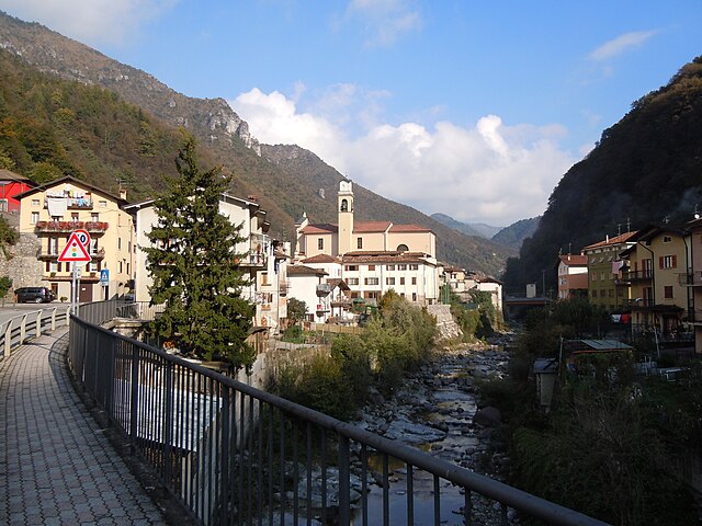
Марментино (Marmentino, Marmentino)
.svg)
- коммуна Италии
 Hiking in Марментино
Marmentino is a charming municipality located in the Province of Brescia in northern Italy. Nestled in the beautiful Italian Alps, it's known for its stunning landscapes, lush forests, and rustic charm. Hiking in Marmentino offers a variety of trails that cater to different skill levels and preferences, making it an excellent destination for both novice and experienced hikers.
Hiking Trails:
-
Sentiero della Valle dei Mirtilli: This trail takes you through scenic blueberry-filled valleys, providing a mix of uphill climbs and gentle slopes. It's great for families and those looking for a leisurely hike.
-
Monte Guglielmo: For a more challenging trek, consider hiking up Monte Guglielmo, which offers breathtaking panoramic views of the surrounding valleys and lakes. The trail can be steep in parts, so proper footwear and fitness are advised.
-
Percorso dei Beni Culturali: This route combines nature and culture, leading you to historical sites and offering insights into the local heritage. It’s a perfect way to learn about the region while enjoying the beauty of the outdoors.
-
Sentiero dei Fiori: This trail is especially appealing in spring and summer when a variety of wildflowers bloom. It’s relatively easy and is suitable for hikers of all ages.
Best Time to Hike:
The best time for hiking in Marmentino is during the spring (April to June) and early autumn (September to October) when the weather is mild, and the trails are less crowded. Summer can also be enjoyable, but be prepared for warmer temperatures and busier trails.
Tips for Hiking in Marmentino:
- Stay Hydrated: Always carry sufficient water, especially on longer hikes.
- Dress Appropriately: Layers are important as temperatures can vary greatly. A good pair of hiking boots and moisture-wicking clothing will enhance your comfort.
- Maps and GPS: While trails are generally well-marked, carrying a map or GPS device is recommended for less familiar paths.
- Local Wildlife: Be aware of the wildlife in the area and maintain a respectful distance from any animals you encounter.
- Follow Leave No Trace Principles: Ensure that the natural beauty of Marmentino remains unspoiled for future hikers.
Local Amenities:
After a day of hiking, you can enjoy the local cuisine in Marmentino's quaint establishments, where you can taste regional dishes. There are also accommodations ranging from guest houses to hotels if you wish to extend your stay.
Marmentino is an exceptional destination for those looking to immerse themselves in nature while enjoying the rich culture of northern Italy. Happy hiking!
- Страна:

- Почтовый код: 25060
- Телефонный код: 030
- Код автомобильного номера: BS
- Координаты: 45° 45' 0" N, 10° 17' 0" E


- GPS треки (wikiloc): [Ссылка]
- Высота над уровнем моря: 875 м m
- Площадь: 18.04 кв.км
- Население: 657
- Веб сайт: http://www.comune.marmentino.bs.it
- Википедия русская: wiki(ru)
- Википедия английская: wiki(en)
- Википедия национальная: wiki(it)
- Хранилище Wikidata: Wikidata: Q105160
- Катеория в википедии: [Ссылка]
- код Freebase: [/m/044w6t]
- код GeoNames: Альт: [6542768]
- код VIAF: Альт: [122717059]
- ID отношения в OpenStreetMap: [45951]
- UN/LOCODE: [ITMMI]
- код ISTAT: 017105
- кадастровый код Италии: E961
Граничит с регионами:
Бовеньо
- коммуна Италии
Hiking in Бовеньо
Bovegno is a charming village located in the province of Brescia, in the Lombardy region of northern Italy. It is nestled in the beautiful Val Sabbia, surrounded by the scenic hills and mountains of the Prealps. The area is known for its stunning natural landscapes, rich flora and fauna, and numerous hiking trails suitable for various skill levels....
- Страна:
- Почтовый код: 25061
- Телефонный код: 030
- Код автомобильного номера: BS
- Координаты: 45° 47' 0" N, 10° 16' 0" E
- GPS треки (wikiloc): [Ссылка]
- Высота над уровнем моря: 680 м m
- Площадь: 47.99 кв.км
- Население: 2146
- Веб сайт: [Ссылка]
Коллио
- коммуна Италии
Hiking in Коллио
Collio is a beautiful wine region located in the northeastern part of Italy, particularly in the Friuli Venezia Giulia region, near the border with Slovenia. It's renowned for its picturesque landscapes, vineyards, and rolling hills, making it an excellent destination for hiking enthusiasts. Here’s what you can expect when hiking in Collio:...
- Страна:
- Почтовый код: 25060
- Телефонный код: 030
- Код автомобильного номера: BS
- Координаты: 45° 49' 0" N, 10° 20' 0" E
- GPS треки (wikiloc): [Ссылка]
- Высота над уровнем моря: 850 м m
- Площадь: 53.48 кв.км
- Население: 2106
- Веб сайт: [Ссылка]
Ирма
- коммуна Италии
Hiking in Ирма
Irma, located in the Lombardy region of Italy, offers a scenic backdrop for hiking enthusiasts who appreciate beautiful landscapes, natural diversity, and a rich cultural context. While Irma itself is a small and relatively lesser-known location, the surrounding area, including the Valtellina Valley and regions nearby, provides ample opportunities for hiking....
- Страна:
- Почтовый код: 25061
- Телефонный код: 030
- Код автомобильного номера: BS
- Координаты: 45° 46' 0" N, 10° 17' 0" E
- GPS треки (wikiloc): [Ссылка]
- Высота над уровнем моря: 804 м m
- Площадь: 4.93 кв.км
- Население: 131
- Веб сайт: [Ссылка]

Лодрино
- коммуна Италии
Hiking in Лодрино
Lodrino, a charming town located in the province of Brescia in Lombardy, Italy, offers some excellent hiking opportunities for those looking to explore the natural beauty of the region. The area is characterized by its scenic landscapes, rolling hills, and proximity to the Oglio River....
- Страна:
- Почтовый код: 25060
- Телефонный код: 030
- Код автомобильного номера: BS
- Координаты: 45° 43' 0" N, 10° 17' 0" E
- GPS треки (wikiloc): [Ссылка]
- Высота над уровнем моря: 725 м m
- Площадь: 16.5 кв.км
- Население: 1669
- Веб сайт: [Ссылка]
Пертика-Альта
- коммуна Италии
Hiking in Пертика-Альта
Pertica Alta is a picturesque area located in the province of Brescia, Italy, known for its stunning landscapes, rich flora and fauna, and various hiking trails suitable for different skill levels. Here are some key points to consider if you're planning to hike in Pertica Alta:...
- Страна:
- Почтовый код: 25070
- Телефонный код: 0365
- Код автомобильного номера: BS
- Координаты: 45° 45' 0" N, 10° 21' 0" E
- GPS треки (wikiloc): [Ссылка]
- Высота над уровнем моря: 900 м m
- Площадь: 20.92 кв.км
- Население: 563
- Веб сайт: [Ссылка]
Пертика-Басса
- коммуна Италии
Hiking in Пертика-Басса
Pertica Bassa is a beautiful area located in the province of Brescia, in Northern Italy. This region is known for its stunning alpine landscapes, lush forests, and charming villages. Hiking in Pertica Bassa offers a variety of trails suitable for different skill levels, making it an excellent destination for both beginners and experienced hikers....
- Страна:
- Почтовый код: 25070
- Телефонный код: 0365
- Код автомобильного номера: BS
- Координаты: 45° 45' 0" N, 10° 22' 0" E
- GPS треки (wikiloc): [Ссылка]
- Высота над уровнем моря: 511 м m
- Площадь: 30.13 кв.км
- Население: 632
- Веб сайт: [Ссылка]
Пеццаце
- коммуна Италии
Hiking in Пеццаце
Pezzaze is a picturesque village located in the province of Brescia, Lombardy, Italy. Nestled in the scenic Valle di Pezzaze, it's surrounded by beautiful mountainous terrain that offers several hiking opportunities for both beginners and experienced hikers....
- Страна:
- Почтовый код: 25060
- Телефонный код: 030
- Код автомобильного номера: BS
- Координаты: 45° 46' 0" N, 10° 14' 0" E
- GPS треки (wikiloc): [Ссылка]
- Высота над уровнем моря: 620 м m
- Площадь: 21.49 кв.км
- Население: 1504
- Веб сайт: [Ссылка]
Таверноле-суль-Мелла
- коммуна Италии
Hiking in Таверноле-суль-Мелла
Tavernole sul Mella is a picturesque village located in the province of Brescia in northern Italy. It's surrounded by beautiful landscapes that offer various hiking opportunities, making it a great destination for outdoor enthusiasts. Here’s some information to consider when hiking in and around Tavernole sul Mella:...
- Страна:
- Почтовый код: 25060
- Телефонный код: 030
- Код автомобильного номера: BS
- Координаты: 45° 44' 46" N, 10° 14' 22" E
- GPS треки (wikiloc): [Ссылка]
- Высота над уровнем моря: 475 м m
- Площадь: 19.81 кв.км
- Население: 1261
- Веб сайт: [Ссылка]