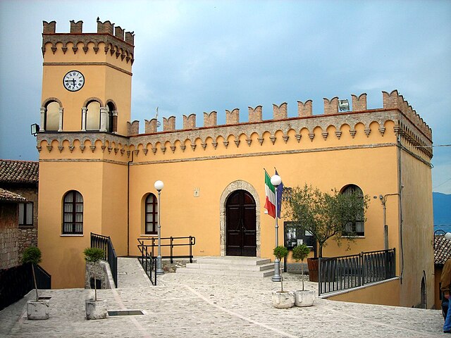
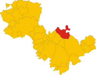
Масса-Мартана (Massa Martana, Massa Martana)
.svg)
- коммуна Италии
 Hiking in Масса-Мартана
Massa Martana, located in the province of Terni in Italy's Umbria region, is a beautiful destination for hiking enthusiasts. The area is characterized by its lush landscapes, rolling hills, and rich historical significance, which makes it an excellent spot for outdoor adventures.
Key Highlights of Hiking in Massa Martana:
-
Natural Beauty: The region offers stunning views of the umbrian countryside, with its vineyards, olive groves, and wildflowers. The trails often provide panoramic vistas of nearby hills and valleys.
-
Historical Trails: Hiking in Massa Martana can also be a journey through history. The area is home to ancient Roman roads and medieval paths, such as the Via Flaminia, which adds a historical dimension to your trekking experience.
-
Protected Areas: Nearby, you can find the Natural Park of the Monti Martani, which is a great place for hiking. The park is characterized by diverse flora and fauna, limestone cliffs, and several well-marked trails ranging in difficulty.
-
Cultural Attractions: As you hike, you can explore charming villages, churches, and ruins that testify to the area's rich cultural heritage. Look out for the Abbey of San Felice and the ruins of the ancient town of the Martani.
-
Trail Variety: There are trails suitable for all levels of hikers, from easy walks for families to more challenging hikes for experienced trekkers. Popular trails often lead to scenic spots like viewpoints or secluded natural sites.
-
Local Cuisine: After a day of hiking, be sure to indulge in the local cuisine. The region is known for its traditional dishes featuring local produce, truffles, and excellent wines.
Tips for Hiking in Massa Martana:
-
Best Time to Visit: Spring (April to June) and fall (September to October) are ideal for hiking, as the weather is usually mild and the scenery is particularly beautiful during these seasons.
-
Preparation: Bring plenty of water, snacks, and sun protection. Depending on the trail, good hiking shoes are highly recommended as some paths can be rocky.
-
Navigation: While many trails are marked, having a map or a hiking app can be helpful to ensure you stay on track.
-
Respect Nature: Always follow the Leave No Trace principles. Stay on marked trails, respect wildlife, and take your litter with you.
With its combination of stunning nature, rich history, and culinary delights, Massa Martana offers a unique hiking experience for those looking to explore the beauty of Umbria.
- Страна:

- Почтовый код: 06056
- Телефонный код: 075
- Код автомобильного номера: PG
- Координаты: 42° 47' 0" N, 12° 31' 0" E


- GPS треки (wikiloc): [Ссылка]
- Высота над уровнем моря: 351 м m
- Площадь: 78.41 кв.км
- Население: 3742
- Веб сайт: http://www.comune.massamartana.pg.it/
- Википедия русская: wiki(ru)
- Википедия английская: wiki(en)
- Википедия национальная: wiki(it)
- Хранилище Wikidata: Wikidata: Q20472
- Катеория в википедии: [Ссылка]
- код Freebase: [/m/07113s]
- код GeoNames: Альт: [6536875]
- код VIAF: Альт: [154798844]
- ID отношения в OpenStreetMap: [42151]
- код GND: Альт: [4596006-9]
- WOEID: [718058]
- код TGN: [7005063]
- UN/LOCODE: [ITZOC]
- код Цифрового атласа Римской империи: [17235]
- код ISTAT: 054028
- кадастровый код Италии: F024
Граничит с регионами:

Джано-делл'Умбрия
- коммуна Италии
Hiking in Джано-делл'Умбрия
Giano dell'Umbria, located in the heart of Umbria, Italy, is a picturesque destination that offers a unique blend of hiking opportunities and breathtaking landscapes. Here’s an overview of what you can expect when hiking in this charming area:...
- Страна:
- Почтовый код: 06030
- Телефонный код: 0742
- Код автомобильного номера: PG
- Координаты: 42° 50' 0" N, 12° 35' 0" E
- GPS треки (wikiloc): [Ссылка]
- Высота над уровнем моря: 547 м m
- Площадь: 44.48 кв.км
- Население: 3893
- Веб сайт: [Ссылка]


Гуальдо-Каттанео
- коммуна Италии
Hiking in Гуальдо-Каттанео
Gualdo Cattaneo, a charming hilltop town in the Umbria region of Italy, offers several hiking opportunities that showcase its beautiful landscapes, rich history, and serene countryside. The area is characterized by rolling hills, vineyards, olive groves, and picturesque views, making it a great destination for outdoor enthusiasts....
- Страна:
- Почтовый код: 06035
- Телефонный код: 0742
- Код автомобильного номера: PG
- Координаты: 42° 55' 0" N, 12° 33' 0" E
- GPS треки (wikiloc): [Ссылка]
- Высота над уровнем моря: 446 м m
- Площадь: 96.63 кв.км
- Население: 5965
- Веб сайт: [Ссылка]


Сполето
- коммуна Италии
Hiking in Сполето
Spoleto, located in the heart of Umbria, Italy, is a fantastic destination for hikers, offering a blend of stunning landscapes, historical significance, and a variety of trails catering to different skill levels. Here’s an overview of what you can expect when hiking in this enchanting region:...
- Страна:
- Почтовый код: 06049
- Телефонный код: 0743
- Код автомобильного номера: PG
- Координаты: 42° 44' 0" N, 12° 44' 0" E
- GPS треки (wikiloc): [Ссылка]
- Высота над уровнем моря: 396 м m
- Площадь: 348.14 кв.км
- Население: 38035
- Веб сайт: [Ссылка]


Тоди
- коммуна Италии
Hiking in Тоди
Todi, a picturesque medieval town in the Umbria region of Italy, offers a range of hiking opportunities that allow you to explore its stunning natural landscapes and rich cultural heritage. Here are some key points to consider if you're planning to hike in Todi:...
- Страна:
- Почтовый код: 06059
- Телефонный код: 075
- Код автомобильного номера: PG
- Координаты: 42° 47' 0" N, 12° 25' 0" E
- GPS треки (wikiloc): [Ссылка]
- Высота над уровнем моря: 410 м m
- Площадь: 222.86 кв.км
- Население: 16606
- Веб сайт: [Ссылка]

Акваспарта
- город в Италии
Hiking in Акваспарта
Acquasparta is a charming town located in the Umbria region of Italy, known for its rich history and beautiful landscapes. It offers a variety of hiking opportunities that allow you to explore the scenic Umbrian countryside, with its rolling hills, ancient ruins, and lush greenery....
- Страна:
- Почтовый код: 05021
- Телефонный код: 0744
- Код автомобильного номера: TR
- Координаты: 42° 41' 0" N, 12° 33' 0" E
- GPS треки (wikiloc): [Ссылка]
- Высота над уровнем моря: 320 м m
- Площадь: 81.61 кв.км
- Население: 4676
- Веб сайт: [Ссылка]