
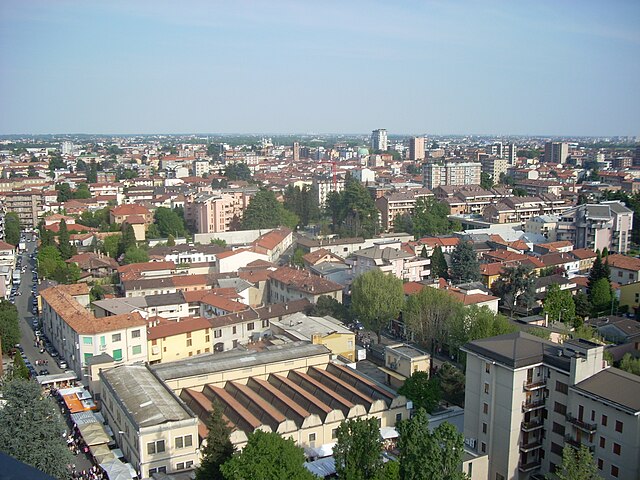
Меда (Meda, Meda)
.svg)
- коммуна Италии
 Hiking in Меда
Meda, a town in Lombardy, Italy, is located near the scenic Brianza region, which is known for its beautiful landscapes, rolling hills, and proximity to the Alps. While Meda itself is more urban and industrial, it serves as a good base for accessing numerous hiking trails in the surrounding areas.
Hiking Opportunities Near Meda:
-
Parco Regionale della Valle del Lambro:
- Located not far from Meda, this regional park features a network of trails that wind through lush forests, along the Lambro River, and past charming villages. It's a great place for both easy and more challenging hikes.
-
Brianza Hills:
- The Brianza region boasts various paths that offer picturesque views of the countryside, including vineyards, farms, and lakes. The trails vary in difficulty, making it suitable for all hikers.
-
Sentiero del Viandante:
- This historical trail, which runs along the eastern shore of Lake Como, can be accessed with a bit of travel from Meda. It offers stunning views of the lake and villages, combining natural beauty with cultural heritage.
-
Monte Cornizzolo:
- A bit further out, Monte Cornizzolo presents a moderately challenging hike with rewarding panoramic views from the summit. The trail is well-marked, and it's a popular spot for both hikers and paragliders.
-
Lago di Pusiano:
- Hikes around this tranquil lake provide opportunities for shorter strolls as well as longer treks along scenic paths. The area is rich in flora and fauna, making it great for nature lovers.
Tips for Hiking in the Area:
-
Weather Conditions: Always check the weather forecast before heading out, as conditions can change rapidly, especially in the mountains.
-
Trail Maps: Carry a reliable map or download GPS tracks in advance, as some trails may not have clear markings.
-
Equipment: Wear suitable hiking boots and clothing that can handle temperature changes. Bring plenty of water and snacks for longer hikes.
-
Local Guidelines: Respect local regulations regarding wildlife and nature conservation. Ensure you are aware of any specific rules in natural parks.
-
Stay Connected: If you're hiking alone, let someone know your plans. Cell reception might be limited in remote areas.
Overall, while Meda may not be a destination for hiking in itself, its strategic location makes it easy to access various beautiful trails and natural experiences in Lombardy. Enjoy your hiking adventures!
- Страна:

- Почтовый код: 20821
- Телефонный код: 0362
- Код автомобильного номера: MB
- Координаты: 45° 40' 0" N, 9° 10' 0" E


- GPS треки (wikiloc): [Ссылка]
- Высота над уровнем моря: 221 м m
- Площадь: 8.31 кв.км
- Население: 23387
- Веб сайт: http://comune.meda.mb.it/
- Википедия русская: wiki(ru)
- Википедия английская: wiki(en)
- Википедия национальная: wiki(it)
- Хранилище Wikidata: Wikidata: Q18112
- Катеория в википедии: [Ссылка]
- код Freebase: [/m/0f4g3g]
- код GeoNames: Альт: [6540586]
- код VIAF: Альт: [156196809]
- ID отношения в OpenStreetMap: [45653]
- идентификатор местоположения ArchINFORM: [7309]
- код LCNAF: Альт: [nb2008000154]
- UN/LOCODE: [ITMED]
- код в Большой каталанской энциклопедии: [0041658]
- код ISTAT: 108030
- кадастровый код Италии: F078
Граничит с регионами:


Кабьате
- коммуна Италии
Hiking in Кабьате
Cabiate, located in the Lombardy region of Italy, is surrounded by beautiful natural landscapes that are ideal for hiking enthusiasts. Here are some highlights and tips for hiking in and around Cabiate:...
- Страна:
- Почтовый код: 22060
- Телефонный код: 031
- Код автомобильного номера: CO
- Координаты: 45° 40' 0" N, 9° 10' 0" E
- GPS треки (wikiloc): [Ссылка]
- Высота над уровнем моря: 237 м m
- Площадь: 3.18 кв.км
- Население: 7509
- Веб сайт: [Ссылка]


Барлассина
- коммуна Италии
Hiking in Барлассина
Barlassina, a charming town located in the Lombardy region of Italy, offers several opportunities for hiking enthusiasts, particularly due to its proximity to beautiful natural landscapes. Here are some key points to consider if you're planning to hike in or around Barlassina:...
- Страна:
- Почтовый код: 20825
- Телефонный код: 0362
- Код автомобильного номера: MB
- Координаты: 45° 39' 0" N, 9° 8' 0" E
- GPS треки (wikiloc): [Ссылка]
- Высота над уровнем моря: 227 м m
- Площадь: 2.76 кв.км
- Население: 7013
- Веб сайт: [Ссылка]


Лентате-суль-Севезо
- коммуна Италии
Hiking in Лентате-суль-Севезо
Lentate sul Seveso, located in the province of Monza and Brianza in Italy, offers a variety of hiking opportunities that showcase the natural beauty of the Lombardy region. Here's an overview of what you can expect when hiking in this area:...
- Страна:
- Почтовый код: 20823
- Телефонный код: 0362
- Код автомобильного номера: MB
- Координаты: 45° 41' 0" N, 9° 7' 0" E
- GPS треки (wikiloc): [Ссылка]
- Высота над уровнем моря: 250 м m
- Площадь: 13.98 кв.км
- Население: 15902
- Веб сайт: [Ссылка]

Сереньо
- коммуна Италии
Hiking in Сереньо
Seregno, located in the Lombardy region of Italy, offers beautiful landscapes and opportunities for hiking, especially in the surrounding areas. While Seregno itself is more urban, the nearby Brianza region is known for its scenic hills, forests, and walking trails. Here are some highlights for hiking in and around Seregno:...
- Страна:
- Почтовый код: 20831
- Телефонный код: 0362
- Код автомобильного номера: MB
- Координаты: 45° 39' 0" N, 9° 12' 0" E
- GPS треки (wikiloc): [Ссылка]
- Высота над уровнем моря: 222 м m
- Площадь: 13.05 кв.км
- Население: 44962
- Веб сайт: [Ссылка]


Севезо
- коммуна Италии
Hiking in Севезо
Seveso is a small town located in the Lombardy region of Italy, near Milan. While it's not particularly known as a hiking destination, there are some areas nearby where you can enjoy outdoor activities, including hiking....
- Страна:
- Почтовый код: 20822
- Телефонный код: 0362
- Код автомобильного номера: MB
- Координаты: 45° 38' 51" N, 9° 8' 19" E
- GPS треки (wikiloc): [Ссылка]
- Высота над уровнем моря: 211 м m
- Площадь: 7.4 кв.км
- Население: 23474
- Веб сайт: [Ссылка]