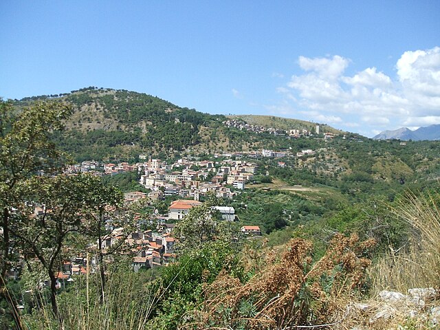
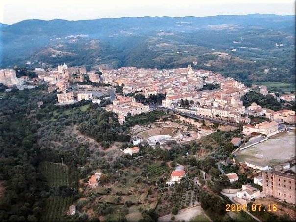
Минтурно (Minturno, Minturno)
.svg)
- коммуна Италии
 Hiking in Минтурно
Minturno, located in the province of Latina, Italy, offers a unique combination of historical sites and beautiful natural scenery, making it a great destination for hiking enthusiasts. The region is characterized by the striking landscapes of the Aurunci Mountains, lush Mediterranean vegetation, and views of the Tyrrhenian Sea.
Key Hiking Areas and Trails:
-
Aurunci Mountains:
- The Aurunci Mountain Range provides numerous hiking opportunities. Trails vary in difficulty, allowing hikers of different experience levels to enjoy the region.
- Popular peaks include Monte Petrella and Monte della Madonna, where you can experience panoramic views of the surrounding area.
-
Monte d'Oro:
- This mountain features trails that take you through stunning forests and rocky terrains. The route can be challenging but rewards hikers with breathtaking views.
-
Historical Sites:
- Along many trails, you can discover ancient ruins, such as the remnants of Roman villas or the fascinating archaeological site of Minturnae.
- Consider hiking to the nearby historic town of Castelforte, which offers a glimpse into the region's rich heritage.
-
Coastal Paths:
- There are also coastal trails that allow you to hike along beautiful stretches of beach and rocky coastline, often connecting to other nearby towns.
Tips for Hiking in Minturno:
- Best Time to Hike: The ideal hiking seasons are spring (April to June) and fall (September to October) when temperatures are mild and the vegetation is lush.
- Preparation: Always check trail conditions before heading out, and ensure you have proper hiking gear, including sturdy footwear, water, and snacks.
- Guided Tours: For those unfamiliar with the area or looking to learn more about its history and ecology, consider joining a guided hiking tour.
Wildlife and Flora:
The area around Minturno is rich in biodiversity, with many local species of plants and animals. As you hike, take the time to observe the unique Mediterranean ecosystem.
In summary, Minturno is a fantastic hiking destination that combines natural beauty with a rich historical backdrop, making it perfect for outdoor enthusiasts looking for an adventure off the beaten path.
- Страна:

- Почтовый код: 04026 - 04028 (Scauri e Marina)
- Телефонный код: 0771
- Код автомобильного номера: LT
- Координаты: 41° 16' 0" N, 13° 45' 0" E


- GPS треки (wikiloc): [Ссылка]
- Высота над уровнем моря: 141 м m
- Площадь: 42.14 кв.км
- Население: 19804
- Веб сайт: http://www.comune.minturno.lt.it
- Википедия русская: wiki(ru)
- Википедия английская: wiki(en)
- Википедия национальная: wiki(it)
- Хранилище Wikidata: Wikidata: Q128105
- Галерея изображений в википедии: [Ссылка]
- Катеория в википедии: [Ссылка]
- код Freebase: [/m/078vgs]
- код GeoNames: Альт: [6541892]
- код BNF: [121685919]
- код VIAF: Альт: [245684013]
- ID отношения в OpenStreetMap: [41180]
- код GND: Альт: [4115157-4]
- UN/LOCODE: [ITMTU]
- код в Большой каталанской энциклопедии: [0266029]
- код Цифрового атласа Римской империи: [35114]
- код ISTAT: 059014
- кадастровый код Италии: F224
Граничит с регионами:
Корено-Аузоньо
- коммуна Италии
Hiking in Корено-Аузоньо
Coreno Ausonio is a picturesque village located in the province of Frosinone, in the Lazio region of Italy. Surrounded by the beautiful landscapes of the Aurunci Mountains and the scenic rolling hills of the Ciociaria area, it offers some excellent opportunities for hiking and enjoying nature....
- Страна:
- Почтовый код: 03040
- Телефонный код: 0776
- Код автомобильного номера: FR
- Координаты: 41° 20' 35" N, 13° 46' 36" E
- GPS треки (wikiloc): [Ссылка]
- Высота над уровнем моря: 318 м m
- Площадь: 26.38 кв.км
- Население: 1613
- Веб сайт: [Ссылка]


Формия
- коммуна Италии
Hiking in Формия
Formia, located on the Tyrrhenian coast of Italy in the Lazio region, is a beautiful destination for hiking enthusiasts. The area is known for its stunning coastal scenery, historical sites, and a variety of trails that cater to different skill levels. Here are some key points about hiking in Formia:...
- Страна:
- Почтовый код: 04023
- Телефонный код: 0771
- Код автомобильного номера: LT
- Координаты: 41° 15' 23" N, 13° 36' 25" E
- GPS треки (wikiloc): [Ссылка]
- Высота над уровнем моря: 19 м m
- Площадь: 74.17 кв.км
- Население: 38032
- Веб сайт: [Ссылка]

Санти-Козма-и-Дамьано
- коммуна Италии
Hiking in Санти-Козма-и-Дамьано
Santi Cosma e Damiano is a charming village located in the province of Latina in the Lazio region of Italy. It's surrounded by beautiful landscapes, rich history, and a variety of trails that can cater to different skill levels – making it a nice destination for hikers....
- Страна:
- Почтовый код: 04020
- Телефонный код: 0771
- Код автомобильного номера: LT
- Координаты: 41° 18' 0" N, 13° 49' 0" E
- GPS треки (wikiloc): [Ссылка]
- Высота над уровнем моря: 181 м m
- Площадь: 31.61 кв.км
- Население: 6972
- Веб сайт: [Ссылка]
Спиньо-Сатурния
- коммуна Италии
Hiking in Спиньо-Сатурния
Spigno Saturnia, located in the province of Latina in Italy, is a lesser-known but breathtaking destination for hiking enthusiasts. Nestled in the beautiful landscapes of the Aurunci Mountains, it offers a variety of trails that cater to different skill levels, from leisurely walks to more challenging hikes....
- Страна:
- Почтовый код: 04020
- Телефонный код: 0771
- Код автомобильного номера: LT
- Координаты: 41° 18' 0" N, 13° 44' 0" E
- GPS треки (wikiloc): [Ссылка]
- Высота над уровнем моря: 51 м m
- Площадь: 38.74 кв.км
- Население: 2937
- Веб сайт: [Ссылка]
Сесса-Аурунка
- коммуна Италии
Hiking in Сесса-Аурунка
Sessa Aurunca, located in the province of Caserta in Campania, Italy, is a beautiful destination for hiking enthusiasts. The region is characterized by its stunning landscapes, rich history, and diverse flora and fauna. Here’s a guide for hiking in Sessa Aurunca:...
- Страна:
- Почтовый код: 81037
- Телефонный код: 0823
- Код автомобильного номера: CE
- Координаты: 41° 14' 0" N, 13° 56' 0" E
- GPS треки (wikiloc): [Ссылка]
- Высота над уровнем моря: 203 м m
- Площадь: 162.18 кв.км
- Население: 21252
- Веб сайт: [Ссылка]