Моэза (Moesa District, Bezirk Moesa)

 Hiking in Моэза
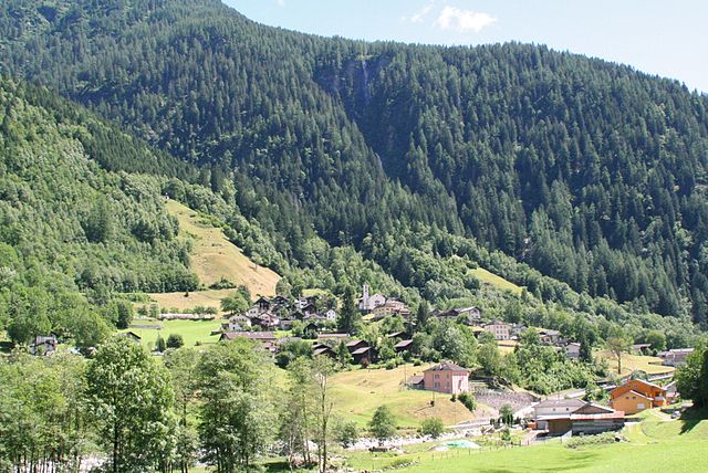
Moesa District, located in the scenic area of Graubünden in Switzerland, offers a range of hiking opportunities for outdoor enthusiasts. The region is characterized by its stunning alpine landscapes, charming villages, and diverse flora and fauna. Here are some highlights and tips for hiking in the Moesa District:
Trails and Routes
-
Scenic Views: Many trails in Moesa offer breathtaking views of the Swiss Alps, with picturesque valleys and mountain peaks. Look for hikes that lead to viewpoints such as Piz Beverin or Monte Zucchero.
-
Different Difficulty Levels: There are trails suitable for all levels, from easy family-friendly walks to challenging alpine hikes. Be sure to choose a trail that matches your hiking experience and fitness level.
-
Historical Trails: The area is rich in history, and some routes will take you through quaint villages where you can experience local culture and architecture. Look for trails that connect communities like Mesocco and Grono.
-
Access to Nature: The Moesa District is known for its biodiversity. Keep an eye out for local wildlife, wildflowers, and unique landscapes such as the forested areas and alpine meadows.
Practical Tips
-
Weather: The weather in the Alps can change rapidly. Always check the forecast before heading out and pack accordingly. Layers, waterproof clothing, and proper footwear are essential.
-
Safety: Make sure to carry sufficient water, snacks, and a map or GPS device. Familiarize yourself with the trail difficulty before you start. Be mindful of your energy levels, especially on longer or more challenging hikes.
-
Guided Tours: If you're unfamiliar with the area, consider joining a guided hiking tour. Local guides can provide insight into the landscape, history, and wildlife, making your hike even more enriching.
-
Respect Nature: Always follow the principles of Leave No Trace. Stick to marked trails, respect wildlife, and ensure you don't disturb the natural surroundings.
Local Attractions
-
Castles: Explore the historical castles in the area, such as the ruins of Mesocco Castle that can be accessed via nearby hiking trails.
-
Culinary Delights: After a long hike, you can enjoy local cuisine at mountain huts or restaurants that feature traditional Swiss dishes.
Conclusion
Hiking in Moesa District is a fantastic way to immerse yourself in the beauty and tranquility of the Swiss landscape. Whether you're seeking a peaceful stroll or an adventurous trek, there's something for everyone. Just remember to plan ahead and hike safely!
- Страна:

- Код автомобильного номера: GR
- Координаты: 46° 14' 0" N, 9° 7' 0" E


- GPS треки (wikiloc): [Ссылка]
- Высота над уровнем моря: 1791 м m
- Площадь: 496.03 кв.км
- Википедия русская: wiki(ru)
- Википедия английская: wiki(en)
- Википедия национальная: wiki(de)
- Хранилище Wikidata: Wikidata: Q664233
- Катеория в википедии: [Ссылка]
- код Freebase: [/m/094jv2]
- код GeoNames: Альт: [7284998]
- идентификатор HDS: [8090]
Включает регионы:
Calanca
Hiking in Calanca
Kreis Calanca, located in the canton of Graubünden in Switzerland, is a stunning region known for its natural beauty and diverse landscapes. The area offers a variety of hiking opportunities that cater to different skill levels, from gentle walks through picturesque villages to more challenging mountain hikes....
- Страна:


Roveredo
Hiking in Roveredo
Kreis Roveredo, located in the canton of Graubünden in Switzerland, is a beautiful area well-suited for hiking enthusiasts. Known for its stunning alpine landscapes, lush valleys, and charming villages, it offers a variety of trails suitable for hikers of all skill levels....
- Страна:

Misox
Hiking in Misox
Kreis Misox, located in the canton of Graubünden in Switzerland, is a beautiful region renowned for its stunning alpine landscapes and excellent hiking opportunities. Here are some key details and highlights for hiking in this area:...
- Страна:
Граничит с регионами:


Ривьера
Hiking in Ривьера
Hiking in the Riviera District offers a unique blend of coastal views, lush landscapes, and charming towns. Here’s a breakdown of what you can typically expect when hiking in this region:...
- Страна:
- Код автомобильного номера: TI
- Координаты: 46° 21' 0" N, 8° 59' 0" E
- GPS треки (wikiloc): [Ссылка]
- Высота над уровнем моря: 264 м m
- Площадь: 166.4 кв.км