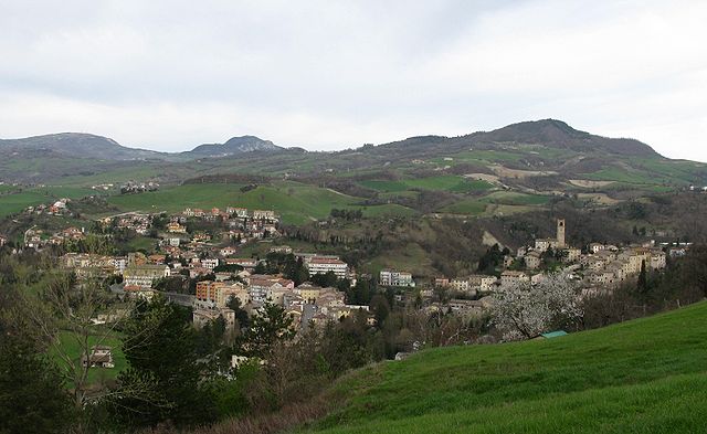
Монте-Гримано-Терме (Monte Grimano, Monte Grimano Terme)
.svg)
- коммуна Италии
 Hiking in Монте-Гримано-Терме
Monte Grimano Terme, located in the Marche region of Italy, is a fantastic destination for hiking enthusiasts. The area is known for its beautiful landscapes, rolling hills, and lush green forests, making it perfect for outdoor activities like hiking.
Hiking Trails
-
Sentiero del Capitano: This is a well-marked trail that offers stunning views of the surrounding countryside. The route often features historical points of interest, including ruins and traditional farmhouses.
-
Monte Grimano Loop: A circular trek that showcases the area's scenic beauty, this trail takes you through woodlands and past meadows, providing opportunities for wildlife spotting.
-
Civita di Monte Grimano: This trail leads you to the nearby medieval village, giving hikers a glimpse of history along with beautiful hiking paths. It's a great combination of culture and nature.
Tips for Hiking in Monte Grimano Terme
- Best Time to Hike: Spring (April to June) and fall (September to October) are ideal for hiking, offering pleasant temperatures and vibrant scenery.
- Hydration and Snacks: Always carry enough water and snacks, especially for longer hikes.
- Footwear: Wear sturdy hiking boots with good grip, as some trails may be rocky or uneven.
- Navigation: While many trails are well-marked, having a map or GPS device can help you stay oriented.
- Local Regulations: Be mindful of local guidelines, especially regarding wildlife and natural preservation.
Attractions Nearby
- Thermal Springs: After a day of hiking, you can relax in the natural springs that Monte Grimano Terme is known for, which can help soothe tired muscles.
- Historical Sites: Consider visiting nearby historical landmarks, including ancient fortifications or local museums to enrich your experience.
Conclusion
Monte Grimano Terme offers a wonderful blend of nature, history, and relaxation for hikers of all levels. Whether you're seeking challenging trails or gentle walks, the region provides a serene escape into the heart of Italy's beautiful landscapes. Enjoy your hiking adventure!
- Страна:

- Почтовый код: 61010
- Телефонный код: 0541
- Код автомобильного номера: PU
- Координаты: 43° 52' 4" N, 12° 28' 16" E


- GPS треки (wikiloc): [Ссылка]
- Высота над уровнем моря: 536 м m
- Площадь: 23.97 кв.км
- Население: 1119
- Веб сайт: http://www.comune.montegrimanoterme.pu.it/
- Википедия русская: wiki(ru)
- Википедия английская: wiki(en)
- Википедия национальная: wiki(it)
- Хранилище Wikidata: Wikidata: Q207231
- Катеория в википедии: [Ссылка]
- код Freebase: [/m/0gl4np]
- код GeoNames: Альт: [6542712]
- ID отношения в OpenStreetMap: [42682]
- код ISTAT: 041035
- кадастровый код Италии: F524
Граничит с регионами:


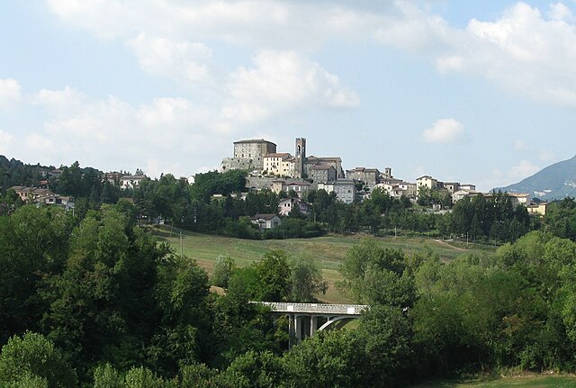
Сан-Лео
- коммуна Италии
Hiking in Сан-Лео
San Leo is a picturesque town located in the Emilia-Romagna region of Italy, perched on a rocky outcrop and surrounded by stunning landscapes. Hiking in and around San Leo offers a unique blend of natural beauty and historical exploration....
- Страна:
- Почтовый код: 47865
- Телефонный код: 0541
- Код автомобильного номера: RN
- Координаты: 43° 53' 47" N, 12° 20' 36" E
- GPS треки (wikiloc): [Ссылка]
- Высота над уровнем моря: 589 м m
- Площадь: 53.14 кв.км
- Население: 2883
- Веб сайт: [Ссылка]

Мачерата-Фельтрия
- коммуна Италии
Hiking in Мачерата-Фельтрия
Macerata Feltria, located in the Marche region of Italy, is a picturesque destination for hiking enthusiasts. This charming town is surrounded by stunning landscapes characterized by rolling hills, lush forests, and historic sites. Here are some highlights and tips for hiking in and around Macerata Feltria:...
- Страна:
- Почтовый код: 61023
- Телефонный код: 0722
- Код автомобильного номера: PU
- Координаты: 43° 48' 12" N, 12° 26' 31" E
- GPS треки (wikiloc): [Ссылка]
- Высота над уровнем моря: 321 м m
- Площадь: 40.07 кв.км
- Население: 2031
- Веб сайт: [Ссылка]


Меркатино-Конка
- коммуна Италии
Hiking in Меркатино-Конка
Mercatino Conca is a charming little town located in the Marche region of Italy, surrounded by beautiful landscapes that are perfect for hiking. The area is characterized by its rolling hills, lush forests, and stunning panoramic views....
- Страна:
- Почтовый код: 61013
- Телефонный код: 0541
- Код автомобильного номера: PU
- Координаты: 43° 52' 14" N, 12° 29' 30" E
- GPS треки (wikiloc): [Ссылка]
- Высота над уровнем моря: 275 м m
- Площадь: 13.95 кв.км
- Население: 1038
- Веб сайт: [Ссылка]

Монте-Чериньоне
- коммуна Италии
Hiking in Монте-Чериньоне
Monte Cerignone is a beautiful area located in the Marche region of Italy, known for its stunning landscapes, rich history, and charming villages. The mountain itself is part of the larger Apennine range and offers various hiking opportunities suitable for different skill levels. Here’s what you can expect when hiking in Monte Cerignone:...
- Страна:
- Почтовый код: 61010
- Телефонный код: 0541
- Код автомобильного номера: PU
- Координаты: 43° 50' 28" N, 12° 24' 46" E
- GPS треки (wikiloc): [Ссылка]
- Высота над уровнем моря: 528 м m
- Площадь: 18.24 кв.км
- Население: 656
- Веб сайт: [Ссылка]


Монтекопиоло
- коммуна Италии
Hiking in Монтекопиоло
Montecopiolo is a beautiful destination for hiking enthusiasts, located in the Marche region of Italy. The area offers a variety of scenic trails with stunning views, rich biodiversity, and the charm of the surrounding Italian countryside....
- Страна:
- Почтовый код: 61014
- Телефонный код: 0722
- Код автомобильного номера: PU
- Координаты: 43° 50' 28" N, 12° 21' 35" E
- GPS треки (wikiloc): [Ссылка]
- Высота над уровнем моря: 915 м m
- Площадь: 35.81 кв.км
- Население: 1101
- Веб сайт: [Ссылка]


Сассофельтрио
- коммуна Италии
Hiking in Сассофельтрио
Sassofeltrio is a picturesque area located in the Marche region of Italy, near the border with San Marino. It's known for its beautiful landscapes, rolling hills, and charming villages. While Sassofeltrio itself may not be as widely recognized as a hiking destination compared to other areas in Italy, it offers various trails that can provide a delightful hiking experience....
- Страна:
- Почтовый код: 61013
- Телефонный код: 0541
- Код автомобильного номера: PU
- Координаты: 43° 53' 31" N, 12° 30' 33" E
- GPS треки (wikiloc): [Ссылка]
- Высота над уровнем моря: 468 м m
- Площадь: 21.08 кв.км
- Население: 1418
- Веб сайт: [Ссылка]