Monteceneri (Monteceneri)

 Hiking in Monteceneri
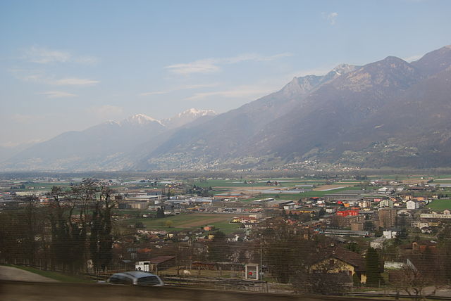
Monteceneri, located in the Canton of Ticino in Switzerland, offers a wonderful blend of natural beauty, rich history, and cultural experiences for hikers. Here's what you can expect when hiking in this picturesque region:
Trails and Terrain
Monteceneri is characterized by a variety of hiking trails that cater to different skill levels, ranging from easy walks to more challenging hikes. The area includes diverse landscapes, such as forests, meadows, and scenic viewpoints overlooking the surrounding valleys and mountains.
- Scenic Views: Many trails provide stunning panoramic views of Lake Lugano, the surrounding mountains, and the Swiss countryside.
- Historical Sites: The region has historical landmarks, including traditional villages and ancient churches, which can be included in your hiking itinerary.
- Nature: The area is rich in flora and fauna, making it a great spot for nature lovers. Keep an eye out for local wildlife and enjoy the diverse plant life along the trails.
Popular Hiking Routes
- Sentiero di Monte Brè: A relatively easy trail that leads to Monte Brè, offering breathtaking views of the surrounding mountains and Lake Lugano.
- Rifugio Alpe di Neggia: A more challenging hike that rewards adventurers with beautiful landscapes and a rustic mountain hut for rest.
- Trail to Monte Generoso: For those looking for a full-day hike, this route takes you to one of the higher peaks in the area, providing stunning vistas.
Practical Tips
- Weather: Always check the weather before your hike, as conditions can change rapidly in the mountains.
- Gear: Wear suitable hiking boots, weather-resistant clothing, and bring plenty of water and snacks.
- Trail Markings: The trails are well-marked, but having a map or GPS device can be helpful, especially for more complex routes.
Accessibility
Monteceneri is accessible by public transport, and many trails can be reached from nearby towns. The region is also well-connected to other popular hiking areas in Ticino, making it a great base for further exploration.
Local Culture
After your hike, consider visiting one of the local restaurants or cafes to enjoy traditional Ticinese cuisine. The region is known for its polenta, risotto, and local wines, offering a perfect way to unwind after an adventurous day.
Overall, hiking in Monteceneri promises to be a rewarding experience, combining physical activity with the chance to appreciate the stunning natural beauty and rich cultural heritage of the region.
- Страна:

- Почтовый код: 6802
- Телефонный код: 091
- Код автомобильного номера: TI
- Координаты: 46° 7' 30" N, 8° 55' 12" E


- GPS треки (wikiloc): [Ссылка]
- Высота над уровнем моря: 554 м m
- Площадь: 36.9 кв.км
- Население: 4502
- Веб сайт: http://www.monteceneri.ch
- Википедия английская: wiki(en)
- Википедия национальная: wiki(de)
- Хранилище Wikidata: Wikidata: Q70633
- Катеория в википедии: [Ссылка]
Граничит с регионами:


Alto Malcantone
Hiking in Alto Malcantone
Alto Malcantone is a beautiful region in the Canton of Ticino, Switzerland, known for its stunning landscapes, serene forests, and picturesque villages. The area offers a variety of hiking trails suitable for different skill levels, making it a great destination for both novice and experienced hikers. Here are some key points to consider if you’re planning a hike in Alto Malcantone:...
- Страна:
- Почтовый код: 6939
- Телефонный код: 91
- Код автомобильного номера: TI
- Координаты: 46° 2' 0" N, 8° 53' 0" E
- GPS треки (wikiloc): [Ссылка]
- Высота над уровнем моря: 810 м m
- Площадь: 22.1 кв.км
- Население: 1405
- Веб сайт: [Ссылка]


Каприаска
Hiking in Каприаска
Capriasca, located in the canton of Ticino in Switzerland, offers beautiful hiking opportunities amid stunning natural landscapes. The region is characterized by its picturesque villages, lush greenery, and breathtaking views of the surrounding mountains and Lake Lugano. Here are some highlights and tips for hiking in Capriasca:...
- Страна:
- Почтовый код: 6950
- Телефонный код: 091
- Код автомобильного номера: TI
- Координаты: 46° 4' 0" N, 8° 58' 0" E
- GPS треки (wikiloc): [Ссылка]
- Высота над уровнем моря: 529 м m
- Площадь: 35.3 кв.км
- Население: 6660
- Веб сайт: [Ссылка]
Cadenazzo
Hiking in Cadenazzo
Cadenazzo is a picturesque village located in the Italian-speaking canton of Ticino, Switzerland. It's known for its beautiful landscapes, charming architecture, and proximity to several hiking trails that cater to different skill levels....
- Страна:
- Почтовый код: 6593
- Телефонный код: 091
- Код автомобильного номера: TI
- Координаты: 46° 8' 48" N, 8° 57' 0" E
- GPS треки (wikiloc): [Ссылка]
- Высота над уровнем моря: 296 м m
- Площадь: 8.44 кв.км
- Население: 2932
- Веб сайт: [Ссылка]


Camorino
Hiking in Camorino
Camorino is a charming location in the Canton of Ticino, Switzerland, known for its scenic beauty and hiking opportunities. Here are some points to consider if you’re planning to hike in the Camorino area:...
- Страна:
- Почтовый код: 6528
- Телефонный код: 091
- Код автомобильного номера: TI
- Координаты: 46° 9' 28" N, 9° 0' 43" E
- GPS треки (wikiloc): [Ссылка]
- Высота над уровнем моря: 535 м m
- Площадь: 8.27 кв.км
- Веб сайт: [Ссылка]

Isone
Hiking in Isone
Isone is a charming municipality located in the Canton of Ticino, Switzerland. It offers a range of hiking opportunities that showcase the stunning landscapes and natural beauty of the region. Here are some details to consider for hiking in Isone:...
- Страна:
- Почтовый код: 6810
- Телефонный код: 091
- Код автомобильного номера: TI
- Координаты: 46° 8' 1" N, 9° 0' 52" E
- GPS треки (wikiloc): [Ссылка]
- Высота над уровнем моря: 1092 м m
- Площадь: 12.9 кв.км
- Население: 378
- Веб сайт: [Ссылка]


Mezzovico-Vira
Hiking in Mezzovico-Vira
Mezzovico-Vira, located in the Swiss canton of Ticino, offers a beautiful hiking experience for outdoor enthusiasts. The region is characterized by its stunning landscapes, with lush greenery, charming villages, and panoramic views of the surrounding mountains and Lake Lugano....
- Страна:
- Почтовый код: 6805
- Телефонный код: 091
- Код автомобильного номера: TI
- Координаты: 46° 6' 0" N, 8° 55' 0" E
- GPS треки (wikiloc): [Ссылка]
- Высота над уровнем моря: 460 м m
- Площадь: 10.2 кв.км
- Население: 1356
- Веб сайт: [Ссылка]
Pianezzo
Hiking in Pianezzo
Pianezzo, located near Lugano in the Swiss canton of Ticino, is a lesser-known but beautiful destination for hiking enthusiasts. The area offers a variety of trails that cater to different skill levels, allowing hikers to enjoy breathtaking views of the surrounding mountains and lakes. Here are some key points to consider when hiking in Pianezzo:...
- Страна:
- Почтовый код: 6582
- Телефонный код: 091
- Код автомобильного номера: TI
- Координаты: 46° 10' 0" N, 9° 2' 0" E
- GPS треки (wikiloc): [Ссылка]
- Высота над уровнем моря: 491 м m
- Площадь: 8.03 кв.км
- Веб сайт: [Ссылка]
Sant'Antonio
Hiking in Sant'Antonio
Sant'Antonio, located near Bellinzona in the canton of Ticino, Switzerland, is a fantastic area for hiking, combining beautiful landscapes with cultural and historical elements. Here’s a guide to what you can expect when hiking in this picturesque region....
- Страна:
- Почтовый код: 6583
- Телефонный код: 091
- Код автомобильного номера: TI
- Координаты: 46° 10' 0" N, 9° 4' 0" E
- GPS треки (wikiloc): [Ссылка]
- Высота над уровнем моря: 822 м m
- Площадь: 33.57 кв.км
- Веб сайт: [Ссылка]