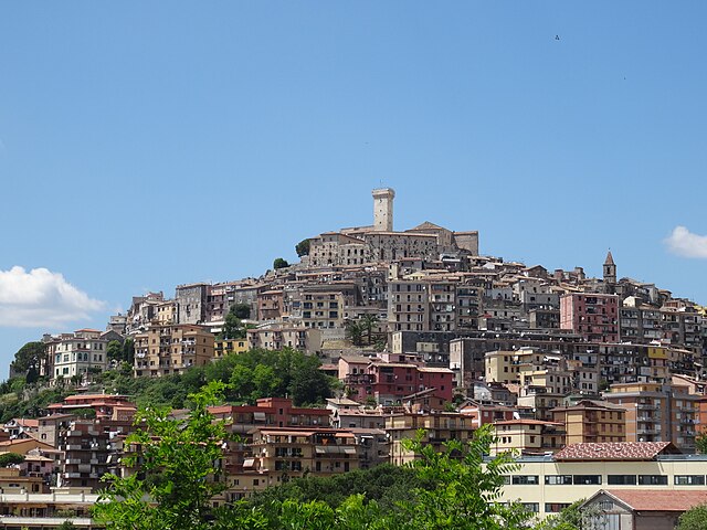
Монтефлавио (Monteflavio, Monteflavio)
.svg)
- коммуна Италии
 Hiking in Монтефлавио
Monteflavio is a charming village located in the Province of Rome, Italy, nestled in the beautiful Sabine Hills. The area around Monteflavio offers several opportunities for hiking, characterized by its lush landscapes, historic sites, and panoramic views.
Hiking Trails:
-
Sentiero di Monteflavio: This local trail enables hikers to immerse themselves in the natural beauty and historical context of the area. The trail often winds through forests, offering glimpses of local flora and fauna.
-
Monte Calvo Trail: A more challenging hike, the trail to Monte Calvo allows for spectacular views of the surrounding countryside and the nearby Apennine Mountains. It's an excellent choice for those looking to experience both nature and a bit of a workout.
-
Nature Reserves: The region is home to several nature reserves and protected areas. Exploring these areas can provide more varied trail options, with opportunities to see wildlife and enjoy peaceful surroundings.
Key Points to Keep in Mind:
-
Best Time to Hike: Spring (April to June) and autumn (September to October) are ideal for hiking in Monteflavio, as temperatures are generally mild, and the landscapes are particularly scenic during these seasons.
-
Preparation: Always check weather conditions before heading out. Bring plenty of water, snacks, and a map or GPS device, as some trails may not be well-marked.
-
Local Culture: Monteflavio is rich in history and culture, so take the time to explore the village itself. Check out local shops and eateries to experience authentic Italian cuisine after a day of hiking.
-
Safety: Stay on marked trails to protect both yourself and the natural environment. Inform someone about your hiking plans, especially if you’re going alone.
Conclusion:
Hiking in Monteflavio offers a delightful blend of nature, culture, and stunning scenery. Whether you are seeking a leisurely walk or a more challenging hike, you’re likely to find something that suits your abilities and interests in this picturesque part of Italy.
- Страна:

- Почтовый код: 00010
- Телефонный код: 0774
- Код автомобильного номера: RM
- Координаты: 42° 6' 30" N, 12° 49' 51" E


- GPS треки (wikiloc): [Ссылка]
- Высота над уровнем моря: 800 м m
- Площадь: 16.84 кв.км
- Население: 1285
- Веб сайт: http://www.comune.monteflavio.rm.it
- Википедия русская: wiki(ru)
- Википедия английская: wiki(en)
- Википедия национальная: wiki(it)
- Хранилище Wikidata: Wikidata: Q142195
- Катеория в википедии: [Ссылка]
- код Freebase: [/m/0gm7nd]
- код GeoNames: Альт: [6542258]
- ID отношения в OpenStreetMap: [41776]
- код ISTAT: 058061
- кадастровый код Италии: F504
Граничит с регионами:
Скандрилья
- коммуна Италии
Hiking in Скандрилья
Scandriglia is a picturesque area located in the Sabina region of Italy, known for its rich natural beauty, historical sites, and charming landscapes. Hiking in Scandriglia offers an opportunity to explore serene countryside, ancient ruins, and stunning views of the surrounding hills and valleys....
- Страна:
- Почтовый код: 02038
- Телефонный код: 0765
- Код автомобильного номера: RI
- Координаты: 42° 10' 0" N, 12° 51' 0" E
- GPS треки (wikiloc): [Ссылка]
- Высота над уровнем моря: 535 м m
- Площадь: 63.35 кв.км
- Население: 3139
- Веб сайт: [Ссылка]


Личенца
- коммуна Италии
Hiking in Личенца
Licenza is a charming town located in the province of Rome, Italy, known for its stunning landscapes, historical sites, and relatively mild climate. Hiking in and around Licenza can be an enjoyable experience, offering a mix of natural beauty and cultural exploration....
- Страна:
- Почтовый код: 00026
- Телефонный код: 0774
- Код автомобильного номера: RM
- Координаты: 42° 4' 27" N, 12° 54' 6" E
- GPS треки (wikiloc): [Ссылка]
- Высота над уровнем моря: 475 м m
- Площадь: 17.99 кв.км
- Население: 950
- Веб сайт: [Ссылка]
Монторио-Романо
- коммуна Италии
Hiking in Монторио-Романо
Montorio Romano is a charming village located in the Lazio region of Italy, surrounded by the stunning natural landscapes of the Sabine Hills and the nearby Simbruini Mountains. Hiking in Montorio Romano offers a variety of trails that cater to different skill levels and preferences, making it an excellent destination for outdoor enthusiasts....
- Страна:
- Почтовый код: 00010
- Телефонный код: 0774
- Код автомобильного номера: ROMA
- Координаты: 42° 8' 16" N, 12° 48' 28" E
- GPS треки (wikiloc): [Ссылка]
- Высота над уровнем моря: 575 м m
- Площадь: 23.39 кв.км
- Население: 1913
- Веб сайт: [Ссылка]
Мориконе
- коммуна Италии
Hiking in Мориконе
Moricone, a picturesque village located in the Lazio region of Italy, is surrounded by beautiful landscapes and offers various hiking opportunities. The surrounding areas are characterized by lush woods, rolling hills, and scenic trails. Here are some key points to consider if you're planning a hiking trip to Moricone:...
- Страна:
- Почтовый код: 00010
- Телефонный код: 0774
- Код автомобильного номера: RM
- Координаты: 42° 7' 0" N, 12° 46' 20" E
- GPS треки (wikiloc): [Ссылка]
- Высота над уровнем моря: 296 м m
- Площадь: 19.59 кв.км
- Население: 2559
- Веб сайт: [Ссылка]

Паломбара-Сабина
- коммуна Италии
Hiking in Паломбара-Сабина
Palombara Sabina, located in the Lazio region of Italy, is a charming town known for its picturesque landscapes and a variety of hiking opportunities. Nestled in the Sabine Hills, it offers a mix of natural beauty, historical sites, and beautiful trails that are perfect for both beginner and experienced hikers....
- Страна:
- Почтовый код: 00018
- Телефонный код: 0774
- Код автомобильного номера: ROMA
- Координаты: 42° 4' 0" N, 12° 46' 0" E
- GPS треки (wikiloc): [Ссылка]
- Высота над уровнем моря: 372 м m
- Площадь: 75.8 кв.км
- Население: 13200
- Веб сайт: [Ссылка]


Сан-Поло-дел-Кавальери
- коммуна Италии
Hiking in Сан-Поло-дел-Кавальери
San Polo dei Cavalieri, located in the Lazio region of Italy, offers a delightful hiking experience amidst beautiful landscapes and rich history. The area is characterized by its picturesque countryside, rolling hills, and lush forests, making it a great destination for hiking enthusiasts of all levels....
- Страна:
- Почтовый код: 00010
- Телефонный код: 0774
- Код автомобильного номера: RM
- Координаты: 42° 1' 0" N, 12° 50' 0" E
- GPS треки (wikiloc): [Ссылка]
- Высота над уровнем моря: 651 м m
- Площадь: 42.53 кв.км
- Население: 2919
- Веб сайт: [Ссылка]