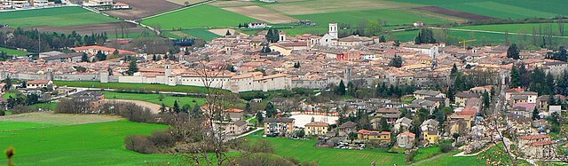
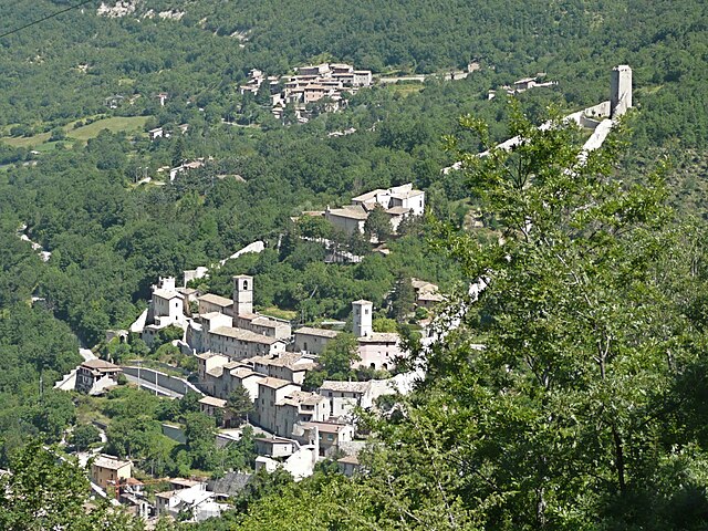
Монтемонако (Montemonaco, Montemonaco)
.svg)
- коммуна Италии
 Hiking in Монтемонако
Montemonaco is a picturesque village located in the Sibillini Mountains National Park in Italy's Marche region. This area is known for its stunning landscapes, diverse flora and fauna, and rich cultural history. Hiking in and around Montemonaco offers various trails suitable for different skill levels, making it an appealing destination for both novice and experienced hikers.
Hiking Trails:
-
Sentiero della Fenestrelle: This trail climbs through beech and fir forests, offering beautiful views of the surrounding mountains. It's relatively easy and great for families.
-
Monte Sibilla: A more challenging hike, the trail to Monte Sibilla provides breathtaking panoramas. There are historical sites along the way, including ancient hermitages.
-
Lago di Pilato: A famous hike that leads to the only glacial lake in the Apennines, Lago di Pilato is a must-see. The trails can be steep and demanding, often requiring a good level of fitness.
-
Valle dell'Infernaccio: This valley features stunning landscapes, ravines, and waterfalls. There are trails of varying difficulty that cater to all levels of hikers.
Best Time to Hike:
The ideal time for hiking in Montemonaco is late spring through early autumn (May to October) when the weather is milder, and trails are usually accessible. However, always check trail conditions, especially after heavy rains or early snowfalls.
Safety Tips:
- Preparation: Carry a good map or GPS device. Some trails may not be well-marked.
- Equipment: Wear sturdy hiking boots and bring enough water, food, and weather-appropriate clothing.
- Weather Awareness: Weather can change rapidly in the mountains; be prepared for sudden shifts.
- Guided Tours: If you're unfamiliar with the area, consider joining a guided hike to learn more about the local ecosystem and history.
Local Attractions:
After your hike, take the time to explore Montemonaco itself, which has charming architecture and is known for its traditional cuisine. The local restaurants often serve delicious dishes featuring regional ingredients.
Hiking in Montemonaco combines physical activity with an appreciation of nature and culture, making it a rewarding experience for outdoor enthusiasts!
- Страна:

- Почтовый код: 63088
- Телефонный код: 0736
- Код автомобильного номера: AP
- Координаты: 42° 53' 57" N, 13° 20' 2" E


- GPS треки (wikiloc): [Ссылка]
- Высота над уровнем моря: 980 м m
- Площадь: 67.81 кв.км
- Население: 568
- Веб сайт: http://www.comunemontemonaco.it
- Википедия русская: wiki(ru)
- Википедия английская: wiki(en)
- Википедия национальная: wiki(it)
- Хранилище Wikidata: Wikidata: Q56082
- Галерея изображений в википедии: [Ссылка]
- Катеория в википедии: [Ссылка]
- код Freebase: [/m/0gl8dm]
- код GeoNames: Альт: [6540463]
- код VIAF: Альт: [245416669]
- ID отношения в OpenStreetMap: [42187]
- Google Maps Customer ID: [9785915671633129554]
- код ISTAT: 044044
- кадастровый код Италии: F570
Граничит с регионами:

Норча
- коммуна Италии
Hiking in Норча
Norcia, located in the Umbria region of Italy, is a fantastic destination for hiking enthusiasts. Nestled in the heart of the Sibillini Mountains, Norcia offers breathtaking landscapes, diverse trails, and rich cultural heritage....
- Страна:
- Почтовый код: 06046
- Телефонный код: 0743
- Код автомобильного номера: PG
- Координаты: 42° 47' 36" N, 13° 5' 38" E
- GPS треки (wikiloc): [Ссылка]
- Высота над уровнем моря: 604 м m
- Площадь: 275.58 кв.км
- Население: 4888
- Веб сайт: [Ссылка]


Аркуата-дель-Тронто
- коммуна Италии
Hiking in Аркуата-дель-Тронто
Arquata del Tronto, located in the Marche region of Italy, is a fantastic destination for hiking enthusiasts. Nestled in the picturesque Sibillini Mountains, the area offers a variety of trails that cater to different skill levels, showcasing stunning landscapes, rich biodiversity, and cultural heritage....
- Страна:
- Почтовый код: 63096
- Телефонный код: 0736
- Код автомобильного номера: AP
- Координаты: 42° 46' 21" N, 13° 17' 48" E
- GPS треки (wikiloc): [Ссылка]
- Высота над уровнем моря: 777 м m
- Площадь: 92.23 кв.км
- Население: 1115
- Веб сайт: [Ссылка]
Комунанца
- коммуна Италии
Hiking in Комунанца
Comunanza is a charming town located in the Marche region of Italy, surrounded by the stunning natural beauty of the Sibillini Mountains National Park. Hiking in this area offers a great variety of trails and landscapes, making it a fantastic destination for outdoor enthusiasts....
- Страна:
- Почтовый код: 63087
- Телефонный код: 0736
- Код автомобильного номера: AP
- Координаты: 42° 57' 26" N, 13° 24' 52" E
- GPS треки (wikiloc): [Ссылка]
- Высота над уровнем моря: 448 м m
- Площадь: 54.4 кв.км
- Население: 3081
- Веб сайт: [Ссылка]
Монтегалло
- коммуна Италии
Hiking in Монтегалло
Montegallo is a beautiful destination located in the Apennine Mountains of central Italy, particularly within the province of Ascoli Piceno in the Marche region. It's known for its stunning landscapes, rolling hills, and rich biodiversity, making it a great spot for hiking enthusiasts....
- Страна:
- Почтовый код: 63094
- Телефонный код: 0736
- Код автомобильного номера: AP
- Координаты: 42° 50' 32" N, 13° 19' 58" E
- GPS треки (wikiloc): [Ссылка]
- Высота над уровнем моря: 870 м m
- Площадь: 48.46 кв.км
- Население: 504
- Веб сайт: [Ссылка]


Монтефортино
- коммуна Италии
Hiking in Монтефортино
Montefortino, located in the Marche region of Italy, is a charming and picturesque destination for hiking enthusiasts. Nestled within the Sibillini Mountains National Park, it offers a diverse range of trails suitable for various skill levels, all surrounded by breathtaking landscapes, rich flora, and fauna....
- Страна:
- Почтовый код: 63858; 63858 (vecchio codice 63044)
- Телефонный код: 0736
- Код автомобильного номера: FM
- Координаты: 42° 56' 34" N, 13° 20' 28" E
- GPS треки (wikiloc): [Ссылка]
- Высота над уровнем моря: 638 м m
- Площадь: 78.62 кв.км
- Население: 1117
- Веб сайт: [Ссылка]
Кастельсантанджело-суль-Нера
- коммуна Италии
Hiking in Кастельсантанджело-суль-Нера
Castelsantangelo sul Nera is a beautiful commune located in the Marche region of Italy, surrounded by stunning natural landscapes that are perfect for hiking enthusiasts. Nestled within the Sibillini Mountains National Park, it offers a variety of trails with diverse levels of difficulty, catering to both beginners and experienced hikers....
- Страна:
- Почтовый код: 62030
- Телефонный код: 0737
- Код автомобильного номера: MC
- Координаты: 42° 53' 41" N, 13° 9' 12" E
- GPS треки (wikiloc): [Ссылка]
- Высота над уровнем моря: 760 м m
- Площадь: 70.67 кв.км
- Население: 260
- Веб сайт: [Ссылка]