Моццаника (Mozzanica, Mozzanica)
.svg)
- коммуна Италии
 Hiking in Моццаника
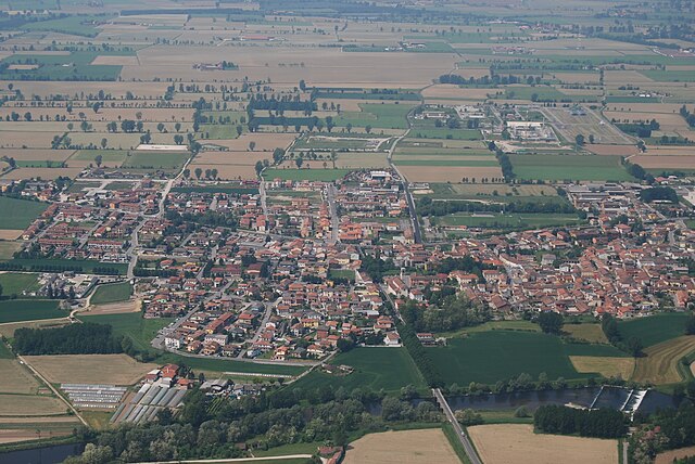
Mozzanica is a small town located in the Lombardy region of Italy, close to the Oglio River. While it may not be widely recognized as a hiking destination, the surrounding areas offer scenic landscapes, agricultural fields, and charming rural settings that are perfect for hiking enthusiasts looking for a peaceful outdoor experience.
Highlights for Hiking in and around Mozzanica
-
Natural Landscapes: The region boasts gentle hills, farmland, and the nearby river, making for pleasant walking paths and trails. The serene environment is ideal for those looking to escape the hustle and bustle of city life.
-
Oglio River: Hiking along the riverbanks can offer beautiful views, unique wildlife spotting opportunities, and an overall peaceful atmosphere. The Oglio River Park, not too far from Mozzanica, features paths suitable for walking, running, and cycling.
-
Local Trails: While specific marked trails may be limited directly in Mozzanica, local farmers’ paths and regional walking routes can provide enjoyable hiking options. Look for signs guiding you through agricultural fields and connecting to neighboring villages.
-
Nearby Natural Parks: Consider exploring the nearby Parco Adda Nord or Parco Oglio Sud, both of which can be accessible for day trips from Mozzanica. These parks provide more extensive hiking trails, natural landscapes, and opportunities for birdwatching and photography.
-
Historic Sites: Incorporate cultural exploration into your hikes by visiting nearby historical sites and towns. The Lombardy region is rich in history, with beautiful architecture and local cuisine, which can make for a well-rounded hiking day.
Tips for Hiking in Mozzanica
- Footwear: Wear comfortable, sturdy hiking shoes suitable for various terrains.
- Weather Considerations: Check the weather before heading out, as it can change, especially in transitional seasons.
- Navigation: While hiking, having a local map or GPS is helpful to find your way along lesser-known paths.
- Hydration: Carry enough water, especially on warm days, and consider bringing snacks for energy during your hike.
- Respect Nature: Follow Leave No Trace principles: pack out what you pack in, and be respectful of wildlife and local habitats.
Conclusion
While Mozzanica itself may not be a well-known hiking hub, the surrounding area has its own charm, offering opportunities for peaceful hikes and the chance to appreciate the beautiful Italian countryside. Whether you're looking for a short walk or a longer trek, the region can cater to diverse hiking interests.
- Страна:

- Почтовый код: 24050
- Телефонный код: 0363
- Код автомобильного номера: BG
- Координаты: 45° 28' 36" N, 9° 41' 19" E


- GPS треки (wikiloc): [Ссылка]
- Высота над уровнем моря: 102 м m
- Площадь: 9.46 кв.км
- Население: 4551
- Веб сайт: http://www.comune.mozzanica.bg.it/
- Википедия русская: wiki(ru)
- Википедия английская: wiki(en)
- Википедия национальная: wiki(it)
- Хранилище Wikidata: Wikidata: Q101262
- Галерея изображений в википедии: [Ссылка]
- Катеория в википедии: [Ссылка]
- код Freebase: [/m/0gjc55]
- код GeoNames: Альт: [6537154]
- код VIAF: Альт: [143170638]
- ID отношения в OpenStreetMap: [45069]
- место в MusicBrainz: [70a19b10-3525-45a3-beb0-1e6eb6c74e8a]
- код темы Quora: [Mozzanica]
- UN/LOCODE: [ITMOZ]
- код ISTAT: 016142
- кадастровый код Италии: F786
- LombardiaBeniCulturali toponym ID: 1000331
Граничит с регионами:


Караваджо
- коммуна Италии
Hiking in Караваджо
Caravaggio, located in the Lombardy region of Italy, is not primarily known as a hiking destination, but it does offer some opportunities for outdoor enthusiasts looking to explore the surrounding areas. The town itself is steeped in history and art, being the namesake of the famous Caravaggio, the Baroque painter....
- Страна:
- Почтовый код: 24043
- Телефонный код: 0363
- Код автомобильного номера: BG
- Координаты: 45° 29' 52" N, 9° 38' 35" E
- GPS треки (wikiloc): [Ссылка]
- Высота над уровнем моря: 111 м m
- Площадь: 32.81 кв.км
- Население: 16261
- Веб сайт: [Ссылка]


Фара-Оливана-кон-Сола
- коммуна Италии
Hiking in Фара-Оливана-кон-Сола
Fara Olivana con Sola is a picturesque village located in the province of Bergamo, Italy, surrounded by the beautiful landscape of the Lombardy region. While it may not be as renowned as some other hiking destinations, it offers some lovely trails and opportunities to explore the natural beauty of the area....
- Страна:
- Почтовый код: 24058
- Телефонный код: 0363
- Код автомобильного номера: BG
- Координаты: 45° 29' 42" N, 9° 44' 57" E
- GPS треки (wikiloc): [Ссылка]
- Высота над уровнем моря: 107 м m
- Площадь: 5.04 кв.км
- Население: 1292
- Веб сайт: [Ссылка]


Форново-Сан-Джованни
- коммуна Италии
Hiking in Форново-Сан-Джованни
Fornovo San Giovanni, located in the Lombardy region of Italy, is not only known for its picturesque landscapes but also offers a variety of hiking opportunities amidst its natural beauty. Here’s an overview of what hiking in that area entails:...
- Страна:
- Почтовый код: 24040
- Телефонный код: 0363
- Код автомобильного номера: BG
- Координаты: 45° 29' 48" N, 9° 40' 38" E
- GPS треки (wikiloc): [Ссылка]
- Высота над уровнем моря: 109 м m
- Площадь: 7.04 кв.км
- Население: 3435
- Веб сайт: [Ссылка]
Кастель-Габбьяно
- коммуна Италии
Hiking in Кастель-Габбьяно
Castel Gabbiano is a picturesque village located in the province of Cremona in Lombardy, Italy. While it may not be as well-known for hiking as some other regions in Italy, there are still opportunities to explore the natural beauty and rural landscapes surrounding this charming area....
- Страна:
- Почтовый код: 26010
- Телефонный код: 0373
- Код автомобильного номера: CR
- Координаты: 45° 28' 0" N, 9° 42' 0" E
- GPS треки (wikiloc): [Ссылка]
- Высота над уровнем моря: 100 м m
- Площадь: 5.79 кв.км
- Население: 475
- Веб сайт: [Ссылка]

Серньано
- коммуна Италии
Hiking in Серньано
Sergnano is a small town located in the Lombardy region of Italy, near the city of Crema. While it's not widely known as a hiking destination, there are a few opportunities for outdoor activities in and around the area....
- Страна:
- Почтовый код: 26010
- Телефонный код: 0373
- Код автомобильного номера: CR
- Координаты: 45° 26' 0" N, 9° 42' 0" E
- GPS треки (wikiloc): [Ссылка]
- Высота над уровнем моря: 88 м m
- Площадь: 12.31 кв.км
- Население: 3568
- Веб сайт: [Ссылка]