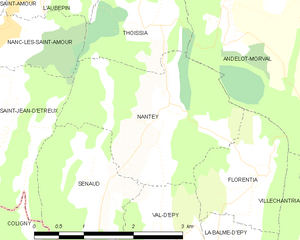
Nanc-lès-Saint-Amour (Nanc-lès-Saint-Amour)
- коммуна во Франции
 Hiking in Nanc-lès-Saint-Amour
Nanc-lès-Saint-Amour is a charming village located in the Jura department in the Bourgogne-Franche-Comté region of eastern France. The area is characterized by its beautiful landscapes, rolling hills, and lush forests, making it a great destination for hiking enthusiasts.
Hiking Trails:
-
Local Trails: Nanc-lès-Saint-Amour has several local trails that meander through scenic countryside, dense woodlands, and past picturesque farms. These trails are often less crowded and provide a more intimate connection with nature.
-
Regional Hiking Routes: The Jura region offers a range of well-marked hiking routes, such as the GR (Grande Randonnée) trails. The GR5 runs through the Jura, providing longer hiking options that can take you through stunning landscapes.
-
Lakes and Rivers: Hiking near nearby lakes and rivers, such as Lake Vouglans or the River Ain, can offer opportunities for both leisurely walks and more challenging hikes. The water bodies enhance the natural beauty and offer spots for picnicking.
Tips for Hiking in Nanc-lès-Saint-Amour:
- Maps and Guides: It's advisable to have a detailed map of the area or a hiking app on your phone to navigate the trails effectively.
- Weather Preparedness: Check the weather before you head out, as conditions can change rapidly in the Jura. Dress in layers and bring appropriate gear.
- Wildlife Watching: Keep an eye out for local wildlife, including various bird species and small mammals. The Jura is rich in biodiversity.
- Local Cuisine: After a day of hiking, consider trying local dishes from nearby villages. The Jura region is known for its cheese and wine.
Safety Considerations:
- Always carry sufficient water and snacks, as well as a first-aid kit.
- Inform someone of your hiking plans and expected return time.
- Stay on marked trails to preserve the natural environment and prevent getting lost.
In summary, Nanc-lès-Saint-Amour provides an excellent base for exploring the beautiful Jura region through its network of hiking trails, offering both tranquility and stunning scenery. Whether you are a beginner or an experienced hiker, there are options available to suit a range of abilities. Enjoy your hike!
- Страна:

- Почтовый код: 39160
- Координаты: 46° 25' 22" N, 5° 21' 31" E


- GPS треки (wikiloc): [Ссылка]
- Высота над уровнем моря: 330 м m
- Площадь: 5.29 кв.км
- Население: 321
- Википедия английская: wiki(en)
- Википедия национальная: wiki(fr)
- Хранилище Wikidata: Wikidata: Q1222319
- Катеория в википедии: [Ссылка]
- код Freebase: [/m/03nq1t4]
- код GeoNames: Альт: [6616721]
- код муниципалитета INSEE: 39378
Граничит с регионами:


L'Aubépin
- коммуна во Франции
Hiking in L'Aubépin
L'Aubépin is a beautiful area that offers a variety of hiking opportunities, typically featuring diverse landscapes, including forests, rivers, cliffs, and possibly agricultural lands. While specific trails may vary, here are some general insights you could expect when hiking in L'Aubépin:...
- Страна:
- Почтовый код: 39160
- Координаты: 46° 26' 23" N, 5° 22' 24" E
- GPS треки (wikiloc): [Ссылка]
- Площадь: 5.67 кв.км
- Население: 148


Saint-Jean-d'Étreux
- коммуна во Франции
Hiking in Saint-Jean-d'Étreux
Saint-Jean-d'Étreux is a small commune located in the Jura department of eastern France, known for its beautiful landscapes and outdoor activities, including hiking. The region is characterized by rolling hills, forests, and diverse flora and fauna, making it a great destination for nature enthusiasts....
- Страна:
- Почтовый код: 39160
- Координаты: 46° 24' 17" N, 5° 21' 30" E
- GPS треки (wikiloc): [Ссылка]
- Площадь: 4.28 кв.км
- Население: 156

Nantey
- коммуна во Франции
Hiking in Nantey
Nantey is a small commune located in the Auvergne-Rhône-Alpes region of southeastern France. While it may not be as widely known for hiking as some of its more famous counterparts in the French Alps, it offers charming landscapes and opportunities for outdoor activities, including hiking. Here’s what you can expect when hiking in and around Nantey:...
- Страна:
- Почтовый код: 39160
- Координаты: 46° 24' 31" N, 5° 23' 57" E
- GPS треки (wikiloc): [Ссылка]
- Площадь: 6.5 кв.км
- Население: 52


Thoissia
- коммуна во Франции
Hiking in Thoissia
It seems like there might be a typo in your query, as "Thoissia" does not correspond to a known hiking destination or region. If you're looking for information on hiking in a specific area, such as a national park, mountain range, or city, please provide the correct name or more context....
- Страна:
- Почтовый код: 39160
- Координаты: 46° 25' 24" N, 5° 23' 43" E
- GPS треки (wikiloc): [Ссылка]
- Площадь: 3.89 кв.км
- Население: 34


Chazelles
Hiking in Chazelles
Chazelles is a charming village located in the Jura region of France, known for its stunning landscapes and outdoor activities, making it a great destination for hiking enthusiasts. The Jura mountains offer a variety of trails that cater to different skill levels, from beginners to experienced hikers....
- Страна:
- Почтовый код: 39160
- Координаты: 46° 24' 15" N, 5° 20' 32" E
- GPS треки (wikiloc): [Ссылка]
- Площадь: 4.04 кв.км
- Население: 147


Сент-Амур
- коммуна во Франции
Hiking in Сент-Амур
Saint-Amour, located in the Jura region of France, offers a wonderful setting for hiking enthusiasts with its beautiful landscapes, rich natural diversity, and charming towns nearby. Here are some highlights and tips for hiking in the Saint-Amour area:...
- Страна:
- Почтовый код: 39160
- Координаты: 46° 26' 8" N, 5° 20' 35" E
- GPS треки (wikiloc): [Ссылка]
- Площадь: 11.65 кв.км
- Население: 2366
- Веб сайт: [Ссылка]

Донсюр
- коммуна во Франции
Hiking in Донсюр
Domsure is a lesser-known hiking destination, and it may not be heavily documented in some hiking resources. However, if you're considering exploring this area, here are some general tips and considerations for hiking in a region like Domsure:...
- Страна:
- Почтовый код: 01270
- Координаты: 46° 25' 9" N, 5° 17' 42" E
- GPS треки (wikiloc): [Ссылка]
- Площадь: 15.2 кв.км
- Население: 480
- Веб сайт: [Ссылка]