Neggio (Neggio)

 Hiking in Neggio
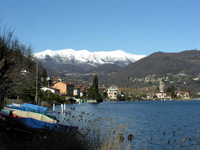
Neggio is a charming village located in the Swiss canton of Ticino, near Lake Lugano. It's a great place for hiking enthusiasts, offering beautiful landscapes, lush forests, and stunning views of the surrounding mountains and valleys. Here are some insights into hiking in Neggio:
Trails and Routes:
-
Local Trails: Neggio boasts several local hiking trails that vary in difficulty. The trails typically weave through picturesque landscapes, dense forests, and vineyards, making it a delightful experience for hikers of all levels.
-
Monti di Neggio: This area features trails that lead to beautiful panoramic viewpoints. The hike to the summit offers breathtaking views of the Lake Lugano and surrounding peaks.
-
Connecting Trails: From Neggio, you can connect to broader hiking routes that lead to neighboring villages such as Arosio, which can offer a full day of exploration.
Scenic Highlights:
- Flora and Fauna: The region is rich in biodiversity, and hikers may encounter various plant species and wildlife, giving you a taste of the local ecosystem.
- Cultural Sites: Along the trails, you might discover quaint churches, historical buildings, and traditional Ticinese architecture.
Tips for Hiking in Neggio:
- Best Time to Hike: Spring and autumn are particularly beautiful times to hike in Neggio, with mild temperatures and vibrant foliage.
- Equipment: Good hiking boots and appropriate clothing are essential, as some trails can be steep or rocky.
- Hydration and Nutrition: Always carry enough water and snacks, especially if you plan to spend the day on the trails.
- Maps and Navigation: It's helpful to have a hiking map or GPS device, as some trails may not be well-marked.
Guided Tours:
If you're unfamiliar with the area, consider joining a guided hiking tour. Local guides can provide insights into the flora, fauna, and history of the region.
Whether you're looking for a leisurely hike or a more challenging trek, Neggio provides a beautiful backdrop for outdoor exploration. Just remember to plan your hike according to your fitness level and experience, and enjoy the stunning natural beauty that Ticino has to offer!
- Страна:

- Почтовый код: 6991
- Телефонный код: 091
- Код автомобильного номера: TI
- Координаты: 45° 59' 21" N, 8° 52' 40" E


- GPS треки (wikiloc): [Ссылка]
- Высота над уровнем моря: 428 м m
- Площадь: 0.9 кв.км
- Население: 317
- Веб сайт: http://www.neggio.ch/
- Википедия английская: wiki(en)
- Википедия национальная: wiki(de)
- Хранилище Wikidata: Wikidata: Q70038
- Катеория в википедии: [Ссылка]
- код Freebase: [/m/0gz71q]
- код GeoNames: Альт: [7286617]
- код VIAF: Альт: [50145067041966631265]
- ID отношения в OpenStreetMap: [1684727]
- код GND: Альт: [1080374906]
- идентификатор местоположения ArchINFORM: [1627]
- идентификатор HDS: [2191]
- код швейцарского муниципалитета: [5206]
Граничит с регионами:


Аньо
- муниципалитет в кантоне Тичино, Швейцария
Hiking in Аньо
Agno, located in the canton of Ticino in Switzerland, offers beautiful hiking opportunities amidst stunning natural landscapes. The region is characterized by its picturesque views of Lake Lugano, lush greenery, and the surrounding mountains, making it an ideal destination for both casual walkers and experienced hikers....
- Страна:
- Почтовый код: 6982
- Телефонный код: 091
- Код автомобильного номера: TI
- Координаты: 46° 0' 1" N, 8° 54' 0" E
- GPS треки (wikiloc): [Ссылка]
- Высота над уровнем моря: 286 м m
- Площадь: 2.5 кв.км
- Население: 4480
- Веб сайт: [Ссылка]

Caslano
Hiking in Caslano
Caslano is a charming village located in the canton of Ticino in southern Switzerland, nestled between Lake Lugano and the surrounding mountains. It offers a range of hiking opportunities that cater to different skill levels, making it a delightful destination for hikers and nature enthusiasts....
- Страна:
- Почтовый код: 6987
- Телефонный код: 091
- Код автомобильного номера: TI
- Координаты: 45° 58' 12" N, 8° 52' 46" E
- GPS треки (wikiloc): [Ссылка]
- Высота над уровнем моря: 291 м m
- Площадь: 2.78 кв.км
- Население: 4330
- Веб сайт: [Ссылка]
Pura
Hiking in Pura
Pura, a charming village in the Canton of Ticino, Switzerland, offers a picturesque setting for hiking enthusiasts. Nestled along the shores of Lake Lugano and surrounded by the stunning Swiss Alps, Pura provides a variety of hiking trails that cater to different skill levels....
- Страна:
- Почтовый код: 6984
- Телефонный код: 091
- Код автомобильного номера: TI
- Координаты: 45° 59' 0" N, 8° 52' 0" E
- GPS треки (wikiloc): [Ссылка]
- Высота над уровнем моря: 387 м m
- Площадь: 3.1 кв.км
- Население: 1364
- Веб сайт: [Ссылка]
Vernate
Hiking in Vernate
Vernate, located in the beautiful region of Ticino in Switzerland, offers a range of hiking opportunities that cater to different skill levels. This area is known for its picturesque landscapes, charming villages, and rich culture, making it a fantastic destination for outdoor enthusiasts....
- Страна:
- Почтовый код: 6992
- Телефонный код: 091
- Код автомобильного номера: TI
- Координаты: 45° 59' 45" N, 8° 52' 49" E
- GPS треки (wikiloc): [Ссылка]
- Высота над уровнем моря: 683 м m
- Площадь: 1.5 кв.км
- Население: 583
- Веб сайт: [Ссылка]
Magliaso
Hiking in Magliaso
Magliaso is a picturesque village located in the Italian-speaking region of Switzerland, specifically in the canton of Ticino. Nestled near Lake Lugano, it offers stunning views and a variety of hiking opportunities that cater to different skill levels. Here are some highlights of hiking in and around Magliaso:...
- Страна:
- Почтовый код: 6983
- Телефонный код: 091
- Код автомобильного номера: TI
- Координаты: 45° 59' 1" N, 8° 53' 18" E
- GPS треки (wikiloc): [Ссылка]
- Высота над уровнем моря: 287 м m
- Площадь: 1.1 кв.км
- Население: 1607
- Веб сайт: [Ссылка]


Curio
Hiking in Curio
Curio is a small village located in the Ticino canton of Switzerland, known for its stunning natural beauty and proximity to the Lugano area. The region offers a variety of hiking trails suitable for different skill levels, making it a great destination for outdoor enthusiasts....
- Страна:
- Почтовый код: 6986
- Телефонный код: 091
- Код автомобильного номера: TI
- Координаты: 46° 0' 9" N, 8° 52' 27" E
- GPS треки (wikiloc): [Ссылка]
- Высота над уровнем моря: 558 м m
- Площадь: 2.84 кв.км
- Население: 544
- Веб сайт: [Ссылка]