Novazzano (Novazzano)

 Hiking in Novazzano
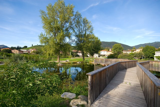
Novazzano is a charming municipality located in the canton of Ticino in southern Switzerland. Nestled in the beautiful landscapes of the Mendrisiotto region, it offers a variety of hiking opportunities with stunning views of the surrounding countryside and the nearby Swiss Alps. Here are some key aspects to consider when hiking in and around Novazzano:
Trails and Routes
-
Local Trails: Novazzano has several marked hiking trails that vary in difficulty. You can find easy routes suitable for families as well as more challenging paths for experienced hikers.
-
Mendrisiotto Region: The nearby region offers extensive hiking networks. Popular routes often lead to picturesque villages, vineyards, and areas rich in cultural heritage.
-
Guided Hikes: If you're new to the area, consider joining a guided hike to learn more about the local flora, fauna, and history.
Key Attractions
- Panoramic Views: Many trails provide breathtaking views of Lake Lugano, the surrounding mountains, and the picturesque landscape of Ticino.
- Cultural Sites: While hiking, you may encounter historical sites, churches, and local landmarks that reflect the rich heritage of the area.
Preparedness Tips
- Weather Conditions: Always check the weather forecast before heading out, as conditions in the Alps can change rapidly.
- Equipment: Wear sturdy hiking boots and consider bringing trekking poles for added stability, especially on rocky or uneven terrain.
- Hydration and Nutrition: Carry enough water and snacks, as some trails may not have access to facilities.
Safety Considerations
- Trail Difficulty: Ensure you choose trails that match your fitness level and hiking experience.
- Wildlife: While encounters with wildlife are rare, it's good to be aware of your surroundings and respectful of nature.
By exploring the hiking options in Novazzano, you can enjoy the serene ambiance of the Swiss countryside while immersing yourself in the natural beauty of the region. Happy hiking!
- Страна:

- Почтовый код: 6883
- Телефонный код: 091
- Код автомобильного номера: TI
- Координаты: 45° 51' 0" N, 8° 59' 0" E


- GPS треки (wikiloc): [Ссылка]
- Высота над уровнем моря: 345 м m
- Площадь: 5.21 кв.км
- Население: 2365
- Веб сайт: http://novazzano.ch
- Википедия английская: wiki(en)
- Википедия национальная: wiki(de)
- Хранилище Wikidata: Wikidata: Q67743
- Катеория в википедии: [Ссылка]
- код Freebase: [/m/0grzs2]
- код GeoNames: Альт: [2659433]
- код VIAF: Альт: [139728012]
- ID отношения в OpenStreetMap: [1684729]
- код GND: Альт: [4572287-0]
- идентификатор местоположения ArchINFORM: [1628]
- идентификатор HDS: [2240]
- код швейцарского муниципалитета: [5260]
Граничит с регионами:


Биццароне
- коммуна Италии
Hiking in Биццароне
Bizzarone is a small town in the Lombardy region of northern Italy, located near the border with Switzerland. While it may not be as widely known for hiking as some larger areas, the surrounding landscapes offer beautiful opportunities for those looking to explore nature....
- Страна:

- Почтовый код: 22020
- Телефонный код: 031
- Код автомобильного номера: CO
- Координаты: 45° 50' 0" N, 8° 57' 0" E
- GPS треки (wikiloc): [Ссылка]
- Высота над уровнем моря: 436 м m
- Площадь: 2.67 кв.км
- Население: 1600
- Веб сайт: [Ссылка]


Угджате-Тревано
- коммуна Италии
Hiking in Угджате-Тревано
Uggiate-Trevano is a charming town located in the province of Como, Lombardy, Italy, near the border with Switzerland. The area offers a variety of hiking opportunities, characterized by beautiful landscapes, rolling hills, and picturesque views of the surrounding regions, including the nearby Lake Como and the Swiss Alps....
- Страна:
- Почтовый код: 22029
- Телефонный код: 031
- Код автомобильного номера: CO
- Координаты: 45° 49' 24" N, 8° 57' 35" E
- GPS треки (wikiloc): [Ссылка]
- Высота над уровнем моря: 414 м m
- Площадь: 5.78 кв.км
- Население: 4946
- Веб сайт: [Ссылка]
Ронаго
- коммуна Италии
Hiking in Ронаго
Ronago is a small town located in the Lombardy region of Italy, near the border with Switzerland. It may not be widely known as a hiking destination, but the surrounding area offers some beautiful landscapes and opportunities for outdoor activities....
- Страна:
- Почтовый код: 22027
- Телефонный код: 031
- Код автомобильного номера: CO
- Координаты: 45° 50' 0" N, 8° 59' 0" E
- GPS треки (wikiloc): [Ссылка]
- Высота над уровнем моря: 357 м m
- Площадь: 2.09 кв.км
- Население: 1716
- Веб сайт: [Ссылка]
Coldrerio
Hiking in Coldrerio
Coldrerio is a charming village located in the region of Ticino in Switzerland, near the border with Italy. It offers a variety of hiking opportunities that cater to different skill levels and preferences. Here are some highlights of hiking in and around Coldrerio:...
- Страна:
- Почтовый код: 6877
- Телефонный код: 091
- Код автомобильного номера: TI
- Координаты: 45° 51' 0" N, 8° 59' 0" E
- GPS треки (wikiloc): [Ссылка]
- Высота над уровнем моря: 351 м m
- Площадь: 2.46 кв.км
- Население: 2927
- Веб сайт: [Ссылка]

Кьяссо
Hiking in Кьяссо
Chiasso, located in the southern part of Switzerland near the border with Italy, is a charming town in the canton of Ticino. While Chiasso itself is more urban and industrial, the surrounding region offers beautiful hiking opportunities, especially in the nearby hills and mountains....
- Страна:
- Почтовый код: 6830
- Телефонный код: 091
- Код автомобильного номера: TI
- Координаты: 45° 50' 7" N, 9° 1' 55" E
- GPS треки (wikiloc): [Ссылка]
- Высота над уровнем моря: 377 м m
- Площадь: 5.3 кв.км
- Население: 8182
- Веб сайт: [Ссылка]

Мендризио
Hiking in Мендризио
Mendrisio, located in the Italian-speaking region of Switzerland, is a fantastic destination for hiking enthusiasts. The area is characterized by its stunning landscapes, charming villages, and impressive views of the surrounding hills and mountains. Here are some key points to consider when hiking in and around Mendrisio:...
- Страна:
- Почтовый код: 6850
- Телефонный код: 091
- Код автомобильного номера: TI
- Координаты: 45° 52' 0" N, 8° 59' 0" E
- GPS треки (wikiloc): [Ссылка]
- Высота над уровнем моря: 354 м m
- Площадь: 32.01 кв.км
- Население: 14914
- Веб сайт: [Ссылка]