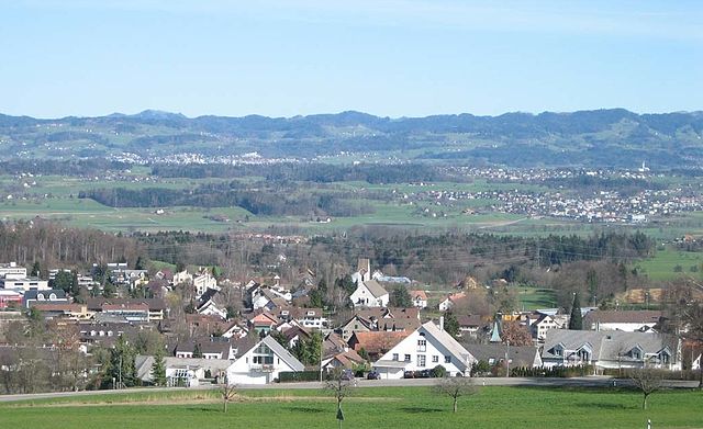
Этвиль-ам-Зе (Oetwil am See, Oetwil am See)

 Hiking in Этвиль-ам-Зе
Oetwil am See, located in the Zurich district of Switzerland, is a picturesque area that offers lovely hiking opportunities. Nestled near the shores of Lake Zurich, it provides a mix of beautiful natural scenery, trails through lush forests, and views of the lake and the surrounding countryside.
Hiking Trails
-
Lake Zurich Trail: A popular option includes trails that skirt along the shore of Lake Zurich, offering stunning views of the water and the Alps in the distance. The section near Oetwil am See is suitable for families and offers relatively flat terrain.
-
Hiking in the surrounding areas: The region has various well-marked trails leading into the nearby hills and forests, where hikers can enjoy more challenging routes. Trails like the Zürcher Oberland route might lead you to higher elevations with rewarding panoramas.
-
Nature Reserves: Explore the nature around Oetwil am See, including local nature reserves that offer an opportunity to observe flora and fauna unique to the region. These often have designated walking paths that vary in difficulty.
Accessibility
Oetwil am See is easily accessible by public transport from Zurich, meaning you can enjoy a day hike without the need for a car. The variability of trails means there’s something for everyone, from beginners to experienced hikers.
Tips for Hiking
- Trail Maps: Be sure to have a good map or a hiking app that shows the trails in the area. Swiss hiking maps are very detailed and helpful.
- Weather Considerations: As the weather can vary greatly, make sure to check forecasts before heading out and be prepared for sudden changes, especially in mountain areas.
- Safety: Bring enough water, snacks, a first-aid kit, and a charged phone for emergencies.
Best Time to Hike
Spring through autumn (April to October) is usually the best time to enjoy hiking around Oetwil am See. Each season provides different scenery, with wildflowers in spring and colorful foliage in autumn.
Overall, Oetwil am See is a lovely base for hiking enthusiasts to explore the beauty of the Zurich region and experience the tranquility of the Swiss countryside.
- Страна:

- Почтовый код: 8618
- Телефонный код: 044
- Код автомобильного номера: ZH
- Координаты: 47° 16' 15" N, 8° 43' 16" E


- GPS треки (wikiloc): [Ссылка]
- Высота над уровнем моря: 538 м m
- Площадь: 6.11 кв.км
- Население: 4754
- Веб сайт: http://www.oetwil.ch
- Википедия русская: wiki(ru)
- Википедия английская: wiki(en)
- Википедия национальная: wiki(de)
- Хранилище Wikidata: Wikidata: Q67354
- Катеория в википедии: [Ссылка]
- код Freebase: [/m/0gv105]
- код GeoNames: Альт: [7286731]
- код VIAF: Альт: [245411721]
- ID отношения в OpenStreetMap: [1682182]
- идентификатор местоположения ArchINFORM: [11132]
- код LCNAF: Альт: [n78043996]
- место в MusicBrainz: [1e4ad361-8391-4e96-9054-8647beb3d07c]
- идентификатор HDS: [112]
- код швейцарского муниципалитета: [0157]
Граничит с регионами:


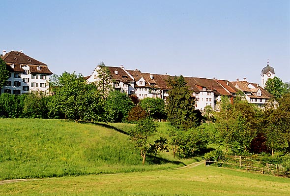
Меннедорф
- город в Швейцарии
Hiking in Меннедорф
Männedorf is a picturesque town located on the shores of Lake Zurich in Switzerland, offering beautiful hiking opportunities with stunning views of the lake and the surrounding mountains. Here are some highlights about hiking in and around Männedorf:...
- Страна:
- Почтовый код: 8708
- Телефонный код: 044
- Код автомобильного номера: ZH
- Координаты: 47° 15' 35" N, 8° 41' 59" E
- GPS треки (wikiloc): [Ссылка]
- Высота над уровнем моря: 498 м m
- Площадь: 4.78 кв.км
- Население: 10957
- Веб сайт: [Ссылка]

Эгг (Цюрих)
Hiking in Эгг (Цюрих)
Egg, located in the Canton of Zurich in Switzerland, is a charming village nestled in the lush landscapes of the Zürcher Oberland. It offers a variety of hiking options suitable for all skill levels. Here are some highlights of hiking in and around Egg:...
- Страна:
- Почтовый код: 8132
- Телефонный код: 01; 043; 044
- Код автомобильного номера: ZH
- Координаты: 47° 18' 7" N, 8° 41' 26" E
- GPS треки (wikiloc): [Ссылка]
- Высота над уровнем моря: 545 м m
- Площадь: 14.48 кв.км
- Население: 8452
- Веб сайт: [Ссылка]


Итикон-ам-Зе
- город в Швейцарии
Hiking in Итикон-ам-Зе
Uetikon am See is a charming municipality located on the shores of Lake Zurich in Switzerland, surrounded by picturesque landscapes and natural beauty. Here are some key points about hiking in and around Uetikon am See:...
- Страна:
- Почтовый код: 8707
- Телефонный код: 044
- Код автомобильного номера: ZH
- Координаты: 47° 16' 1" N, 8° 40' 38" E
- GPS треки (wikiloc): [Ссылка]
- Высота над уровнем моря: 450 м m
- Площадь: 3.49 кв.км
- Население: 6145
- Веб сайт: [Ссылка]
Грюнинген
Hiking in Грюнинген
Grüningen is a charming municipality located in Switzerland, near the city of Zurich. It offers beautiful landscapes and trails that cater to varying skill levels, making it a great destination for hiking enthusiasts. Here are some highlights about hiking in Grüningen:...
- Страна:
- Почтовый код: 8627
- Телефонный код: 044; 043
- Код автомобильного номера: ZH
- Координаты: 47° 17' 3" N, 8° 45' 45" E
- GPS треки (wikiloc): [Ссылка]
- Высота над уровнем моря: 502 м m
- Площадь: 8.78 кв.км
- Население: 3361
- Веб сайт: [Ссылка]


Хомбрехтикон
- Хомбрехтикон в Швейцарии, в кантоне Цюрих.
Hiking in Хомбрехтикон
Hombrechtikon is a charming area located in the Zurich Oberland region of Switzerland, surrounded by beautiful landscapes, forests, and lakes. Hiking in and around Hombrechtikon offers a variety of trails that cater to different skill levels and preferences....
- Страна:
- Почтовый код: 8634
- Телефонный код: 055
- Код автомобильного номера: ZH
- Координаты: 47° 15' 10" N, 8° 46' 7" E
- GPS треки (wikiloc): [Ссылка]
- Высота над уровнем моря: 501 м m
- Площадь: 12.19 кв.км
- Население: 8595
- Веб сайт: [Ссылка]


Штефа
- город в Швейцарии
Hiking in Штефа
Stäfa, located on the eastern shore of Lake Zurich in Switzerland, is a charming town that offers various hiking opportunities with stunning views of the lake and surrounding landscapes. Here are some highlights for hiking in and around Stäfa:...
- Страна:
- Почтовый код: 8712
- Телефонный код: 044; 043
- Код автомобильного номера: ZH
- Координаты: 47° 14' 24" N, 8° 43' 58" E
- GPS треки (wikiloc): [Ссылка]
- Высота над уровнем моря: 523 м m
- Площадь: 8.59 кв.км
- Население: 14389
- Веб сайт: [Ссылка]