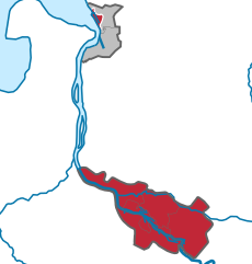
Остерхольц (Osterholz, Landkreis Osterholz)


 Hiking in Остерхольц
Osterholz, located in Lower Saxony, Germany, offers a variety of hiking opportunities for outdoor enthusiasts. The region is characterized by its beautiful landscapes, including forests, heathlands, and rivers, providing a picturesque setting for hikers. Here are some highlights and tips for hiking in Osterholz:
Trails and Natural Areas
-
Osterholz-Scharmbeck: This area features several well-marked trails that take you through serene woodlands and along riverbanks. Look for paths that provide views of the Hamme River, which adds charm to your hiking experience.
-
Nature Reserves: The surrounding nature reserves, such as the Hamberger Moor, offer trails that allow you to explore rich biodiversity and unique ecosystems. Birdwatching can also be quite rewarding in these areas.
-
Heathlands: The Teufelsmoor region nearby, known for its moorland landscapes, provides fascinating trails. These areas are especially beautiful in late summer when the heather is in bloom.
Local Tips
- Trail Maps: It’s wise to have a local hiking map or use a navigation app, as some trails may not always be well-marked.
- Weather Preparedness: The weather in Lower Saxony can be unpredictable, so wear layers and bring waterproof gear, especially in autumn and spring.
- Wildlife Awareness: Be aware of local wildlife and practice good outdoor etiquette; always stay on marked trails to protect the natural habitat.
Additional Activities
Many trails in and around Osterholz can also be combined with other activities such as cycling or birdwatching. The region is rich in cultural history, so consider checking out any nearby historical landmarks or quaint villages to enhance your hiking experience.
Safety Considerations
As with any outdoor activity, it's important to inform someone of your hiking plans, stay hydrated, and bring snacks. Always follow local guidelines and regulations to ensure a safe and enjoyable hike.
Exploring the scenic landscapes and quiet trails of Osterholz can be a refreshing outdoor adventure. Enjoy your hike!
- Страна:

- Столица: Остерхольц-Шармбек
- Код автомобильного номера: OHZ
- Координаты: 53° 15' 0" N, 8° 49' 48" E


- GPS треки (wikiloc): [Ссылка]
- Высота над уровнем моря: 3 м m
- Площадь: 650.73 кв.км
- Население: 112695
- Веб сайт: http://www.landkreis-osterholz.de/
- Википедия русская: wiki(ru)
- Википедия английская: wiki(en)
- Википедия национальная: wiki(de)
- Хранилище Wikidata: Wikidata: Q5926
- Катеория в википедии: [Ссылка]
- код Freebase: [/m/0137ng]
- код Freebase: [/m/0137ng]
- код Freebase: [/m/0137ng]
- код GeoNames: Альт: [3221042]
- код GeoNames: Альт: [3221042]
- код GeoNames: Альт: [3221042]
- код VIAF: Альт: [125572202]
- код VIAF: Альт: [125572202]
- код VIAF: Альт: [125572202]
- ID отношения в OpenStreetMap: [62399]
- ID отношения в OpenStreetMap: [62399]
- ID отношения в OpenStreetMap: [62399]
- код GND: Альт: [4126195-1]
- код GND: Альт: [4126195-1]
- код GND: Альт: [4126195-1]
- идентификатор местоположения ArchINFORM: [3093]
- идентификатор местоположения ArchINFORM: [3093]
- идентификатор местоположения ArchINFORM: [3093]
- код LCNAF: Альт: [n86073733]
- код LCNAF: Альт: [n86073733]
- код LCNAF: Альт: [n86073733]
- код TGN: [7076852]
- код TGN: [7076852]
- код TGN: [7076852]
- код ISNI: Альт: [0000 0004 0415 9000]
- код ISNI: Альт: [0000 0004 0415 9000]
- код ISNI: Альт: [0000 0004 0415 9000]
- код NLI: [001015156]
- код NLI: [001015156]
- код NLI: [001015156]
- код NUTS: [DE936]
- код NUTS: [DE936]
- код NUTS: [DE936]
- идентификатор Ringgold: [169372]
- идентификатор Ringgold: [169372]
- идентификатор Ringgold: [169372]
- код района Германии: 03356
- код района Германии: 03356
- код района Германии: 03356
Включает регионы:


Остерхольц-Шармбек
Hiking in Остерхольц-Шармбек
Osterholz-Scharmbeck, located in Lower Saxony, Germany, offers a variety of opportunities for hiking enthusiasts. The region is known for its diverse landscapes, including forests, meadows, and wetlands, making it a great destination for outdoor activities....
- Страна:
- Почтовый код: 27711
- Телефонный код: 04795; 04793; 04791
- Код автомобильного номера: OHZ
- Координаты: 53° 13' 37" N, 8° 47' 41" E
- GPS треки (wikiloc): [Ссылка]
- Высота над уровнем моря: 11 м m
- Площадь: 147 кв.км
- Население: 30398
- Веб сайт: [Ссылка]

Хамберген
Hiking in Хамберген
Hambergen is a small municipality in Lower Saxony, Germany, located in the district of Rotenburg (Wümme). While it's not as well-known for hiking as some larger national parks or regions, it offers scenic landscapes, rural pathways, and a peaceful environment that can be enjoyable for outdoor enthusiasts and hikers....
- Страна:
- Координаты: 53° 18' 0" N, 8° 51' 0" E
- GPS треки (wikiloc): [Ссылка]
- Площадь: 135 кв.км
- Население: 11819
- Веб сайт: [Ссылка]
Граничит с регионами:

Бремен
- город в Германии
Hiking in Бремен
Bremen, while primarily known for its rich history and vibrant cultural scene, doesn't have the extensive hiking trails commonly found in more mountainous regions of Germany. However, there are some lovely outdoor areas and walking opportunities nearby that can satisfy those looking for a hiking experience....
- Страна:
- Почтовый код: 28779; 28777; 28759; 28757; 28755; 28719; 28717; 28359; 28357; 28355; 28329; 28327; 28325; 28309; 28307; 28279; 28277; 28259; 28239; 28237; 28219; 28217; 28215; 28213; 28211; 28209; 28207; 28205; 28203; 28201; 28199; 28197; 28195
- Телефонный код: 0421
- Код автомобильного номера: HB
- Координаты: 53° 4' 37" N, 8° 48' 32" E
- GPS треки (wikiloc): [Ссылка]
- Высота над уровнем моря: 6 м m
- Площадь: 326.18 кв.км
- Население: 568006
- Веб сайт: [Ссылка]

Куксхафен
Hiking in Куксхафен
Cuxhaven, located in Lower Saxony, Germany, offers a unique hiking experience with its combination of coastal landscapes, nature reserves, and historical sites. Here are some highlights of hiking in the Cuxhaven district:...
- Страна:
- Столица: Куксхафен
- Код автомобильного номера: CUX
- Координаты: 53° 40' 12" N, 8° 49' 48" E
- GPS треки (wikiloc): [Ссылка]
- Высота над уровнем моря: 5 м m
- Площадь: 2057.78 кв.км
- Население: 198670
- Веб сайт: [Ссылка]


Ферден
Hiking in Ферден
Verden, located in Lower Saxony, Germany, is an area that offers various outdoor activities, including hiking. The district is characterized by its lush landscapes, woodlands, and scenic countryside, making it a pleasant spot for nature lovers and hikers alike....
- Страна:
- Код автомобильного номера: VER
- Координаты: 53° 0' 0" N, 9° 10' 12" E
- GPS треки (wikiloc): [Ссылка]
- Высота над уровнем моря: 23 м m
- Площадь: 787.70 кв.км
- Население: 135842
- Веб сайт: [Ссылка]


Везермарш
Hiking in Везермарш
Wesermarsch is a fascinating region in Lower Saxony, Germany, known for its flat landscapes, unique marsh ecosystems, and rich cultural heritage. While it may not be as mountainous as other hiking destinations, it offers a variety of hiking trails suitable for all levels, especially for those who enjoy tranquil walks in nature and picturesque views....
- Страна:
- Столица: Браке
- Код автомобильного номера: BRA
- Координаты: 53° 19' 48" N, 8° 19' 48" E
- GPS треки (wikiloc): [Ссылка]
- Площадь: 821.87 кв.км
- Население: 89282
- Веб сайт: [Ссылка]