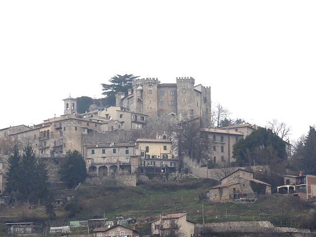
Пескороккьяно (Pescorocchiano, Pescorocchiano)
.svg)
- коммуна Италии
 Hiking in Пескороккьяно
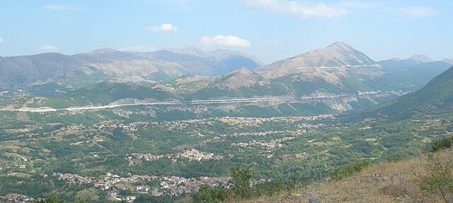
Pescorocchiano is a charming village located in the province of Rieti in the Lazio region of Italy. It serves as an excellent base for hikers who want to explore the surrounding natural beauty and historical sites. The area is characterized by lush landscapes, rolling hills, and picturesque views, making it a fantastic destination for outdoor enthusiasts.
Hiking Trails
Here are some highlights of hiking opportunities around Pescorocchiano:
-
Monti della Laga: This mountain range is not far from Pescorocchiano and offers numerous trails for various skill levels. The landscapes are stunning, with rocky outcrops, deep valleys, and rich flora and fauna.
-
Fountain of Rascino: There are hiking routes that lead you to scenic spots like the Fountain of Rascino. Trails around here often provide panoramic views of the surrounding valleys.
-
Historic Routes: The area is steeped in history, and some trails follow ancient paths that connect different medieval villages. These hikes provide a cultural experience as well as a physical challenge.
-
Nature Reserves: Nearby nature reserves such as the Monte Soratte Regional Park offer well-marked trails that allow hikers to explore diverse ecosystems, including oak forests and brushland.
Hiking Tips
- Plan Ahead: Always check trail conditions and maps before heading out. It’s good to know the level of difficulty and length of your chosen route.
- Pack Essentials: Bring enough water, snacks, a first aid kit, and weather-appropriate clothing. A map or GPS is also helpful.
- Respect Nature: Stay on marked trails to preserve the local wildlife and plant life. Follow the Leave No Trace principles.
- Local Guides: Consider hiring a local guide for a more enriching experience, especially if you're interested in the flora, fauna, and history of the area.
Best Time to Hike
The best times for hiking in and around Pescorocchiano are during the spring and fall when temperatures are milder and the landscapes are particularly vibrant. Summer can be quite warm, so early morning or late afternoon hikes are preferable.
Conclusion
Pescorocchiano offers a wonderful opportunity for hiking enthusiasts to delve into nature and explore the stunning landscapes of Lazio. Whether you're looking for easy walks or more challenging hikes, there's something for everyone in this beautiful region of Italy. Remember to enjoy the journey and take in the breathtaking scenery!
- Страна:

- Почтовый код: 02024
- Телефонный код: 0746
- Код автомобильного номера: RI
- Координаты: 42° 12' 0" N, 13° 9' 0" E


- GPS треки (wikiloc): [Ссылка]
- Высота над уровнем моря: 806 м m
- Площадь: 94.78 кв.км
- Население: 2050
- Веб сайт: http://www.comunepescorocchiano.rieti.it/
- Википедия русская: wiki(ru)
- Википедия английская: wiki(en)
- Википедия национальная: wiki(it)
- Хранилище Wikidata: Wikidata: Q224293
- Катеория в википедии: [Ссылка]
- код Freebase: [/m/0gm5yh]
- код GeoNames: Альт: [6538657]
- код VIAF: Альт: [247428590]
- ID отношения в OpenStreetMap: [41821]
- код Цифрового атласа Римской империи: [22565]
- код ISTAT: 057049
- кадастровый код Италии: G498
Граничит с регионами:
Фьяминьяно
- коммуна Италии
Hiking in Фьяминьяно
Fiamignano, a picturesque village in the province of Rieti in Italy, is surrounded by beautiful landscapes and offers numerous hiking opportunities. Situated in the heart of the Apennines, hiking in this region provides stunning views, diverse flora and fauna, and a chance to explore local culture and history....
- Страна:
- Почтовый код: 02023
- Телефонный код: 0746
- Код автомобильного номера: RI
- Координаты: 42° 16' 0" N, 13° 8' 0" E
- GPS треки (wikiloc): [Ссылка]
- Высота над уровнем моря: 988 м m
- Площадь: 100.62 кв.км
- Население: 1337
- Веб сайт: [Ссылка]
Боргорозе
- коммуна Италии
Hiking in Боргорозе
Borgorose is a beautiful destination for hiking enthusiasts, located in the Abruzzo region of Italy. It's surrounded by stunning natural landscapes, including mountains, forests, and rivers, making it an appealing spot for outdoor activities....
- Страна:
- Почтовый код: 02021
- Телефонный код: 0746
- Код автомобильного номера: RI
- Координаты: 42° 12' 0" N, 13° 14' 0" E
- GPS треки (wikiloc): [Ссылка]
- Высота над уровнем моря: 732 м m
- Площадь: 145.82 кв.км
- Население: 4486
- Веб сайт: [Ссылка]

Коллальто-Сабино
- коммуна Италии
Hiking in Коллальто-Сабино
Collalto Sabino, located in the Province of Rieti in the Lazio region of Italy, offers a range of beautiful hiking opportunities set in a stunning natural landscape. Here are some highlights of hiking in this area:...
- Страна:
- Почтовый код: 02022
- Телефонный код: 0765
- Код автомобильного номера: RI
- Координаты: 42° 8' 12" N, 13° 2' 54" E
- GPS треки (wikiloc): [Ссылка]
- Высота над уровнем моря: 980 м m
- Площадь: 22.37 кв.км
- Население: 416
- Веб сайт: [Ссылка]
Марчетелли
- коммуна Италии
Hiking in Марчетелли
Marcetelli is a picturesque village located in the Lazio region of Italy, specifically in the province of Rieti. It is surrounded by beautiful natural landscapes, making it an excellent destination for hiking enthusiasts. The area is characterized by its rolling hills, dense forests, and stunning views of the Apennines....
- Страна:
- Почтовый код: 02020
- Телефонный код: 0765
- Код автомобильного номера: RI
- Координаты: 42° 14' 0" N, 13° 3' 0" E
- GPS треки (wikiloc): [Ссылка]
- Высота над уровнем моря: 930 м m
- Площадь: 11.08 кв.км
- Население: 76
- Веб сайт: [Ссылка]


Петрелла-Сальто
- коммуна Италии
Hiking in Петрелла-Сальто
Petrella Salto is a charming village nestled in the Lazio region of Italy, surrounded by beautiful landscapes and rich natural beauty, making it an excellent destination for hiking enthusiasts. Here are some aspects to consider if you're thinking about hiking in this area:...
- Страна:
- Почтовый код: 02025
- Телефонный код: 0746
- Код автомобильного номера: RI
- Координаты: 42° 18' 0" N, 13° 4' 0" E
- GPS треки (wikiloc): [Ссылка]
- Высота над уровнем моря: 786 м m
- Площадь: 102.93 кв.км
- Население: 1146
- Веб сайт: [Ссылка]
Варко-Сабино
- коммуна Италии
Hiking in Варко-Сабино
Varco Sabino is a beautiful area located in the Lazio region of Italy, known for its stunning landscapes and natural beauty. It offers a variety of hiking trails that cater to different skill levels, making it a great destination for both beginners and experienced hikers....
- Страна:
- Почтовый код: 02020
- Телефонный код: 0765
- Код автомобильного номера: RI
- Координаты: 42° 14' 0" N, 13° 1' 0" E
- GPS треки (wikiloc): [Ссылка]
- Высота над уровнем моря: 742 м m
- Площадь: 24.75 кв.км
- Население: 172
- Веб сайт: [Ссылка]


Карсоли
- коммуна в Италии
Hiking in Карсоли
Carsoli, located in the Abruzzo region of Italy, offers some beautiful hiking opportunities amidst its picturesque landscapes, rich history, and diverse flora and fauna. Here are some highlights and tips for hiking in and around Carsoli:...
- Страна:
- Почтовый код: 67061
- Телефонный код: 0863
- Код автомобильного номера: AQ
- Координаты: 42° 5' 56" N, 13° 5' 19" E
- GPS треки (wikiloc): [Ссылка]
- Высота над уровнем моря: 616 м m
- Площадь: 95.8 кв.км
- Население: 5314
- Веб сайт: [Ссылка]


Санте-Мария
- коммуна Италии
Hiking in Санте-Мария
Sainte-Marie is a beautiful destination for hiking enthusiasts, especially for those who enjoy natural beauty, coastal views, and a mix of terrain. Located in the French overseas department of Martinique, Sainte-Marie offers a variety of trails that cater to different experience levels. Here are some key points to consider when hiking in Sainte-Marie:...
- Страна:
- Почтовый код: 67067
- Телефонный код: 0863
- Код автомобильного номера: AQ
- Координаты: 42° 6' 16" N, 13° 12' 5" E
- GPS треки (wikiloc): [Ссылка]
- Высота над уровнем моря: 850 м m
- Площадь: 40.82 кв.км
- Население: 1159
- Веб сайт: [Ссылка]

Торнимпарте
- коммуна Италии
Hiking in Торнимпарте
Tornimparte is a picturesque village located in the province of Ávila, in the autonomous community of Castilla y León, Spain. Nestled in the Sierra de Villafranca, it provides access to beautiful natural landscapes and several hiking opportunities....
- Страна:
- Почтовый код: 67049
- Телефонный код: 0862
- Код автомобильного номера: AQ
- Координаты: 42° 17' 24" N, 13° 18' 3" E
- GPS треки (wikiloc): [Ссылка]
- Высота над уровнем моря: 830 м m
- Площадь: 65.96 кв.км
- Население: 3152
- Веб сайт: [Ссылка]