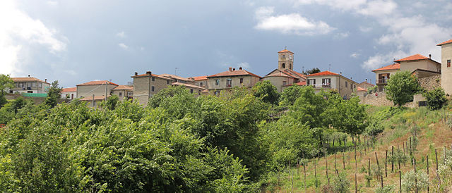
Пеццоло-Валле-Уццоне (Pezzolo Valle Uzzone, Pezzolo Valle Uzzone)
- коммуна Италии
 Hiking in Пеццоло-Валле-Уццоне
Pezzolo Valle Uzzone is a charming small village located in the Piedmont region of Italy, surrounded by picturesque landscapes and rolling hills. Hiking in this area offers a wonderful combination of scenic views, rich natural beauty, and the opportunity to explore local wildlife and flora. Here are some key points regarding hiking in Pezzolo Valle Uzzone:
Trails and Routes
-
Local Trails: There are several well-maintained trails around Pezzolo that range in difficulty, from easy walks suitable for families to more challenging routes for experienced hikers. Be sure to check local maps or apps for detailed trail information.
-
Natural Parks: The area is close to the Langa and Roero regions, famous for their vineyards and beautiful landscapes. You can connect to broader trails that traverse these natural parks, offering a mix of forested paths and open vineyards.
-
Historical Routes: Some trails may take you through historical sites, including old stone villages and ancient church ruins, allowing for both a cultural and recreational experience.
Best Time to Hike
- Spring and Fall: These seasons are particularly beautiful for hiking, as temperatures are moderate, and the scenery is vibrant with blooming flowers in spring and stunning fall foliage.
- Summer: While summer offers lush landscapes, it can get hot, so early mornings or late afternoons are ideal for hiking.
Tips for Hikers
- Preparation: Make sure to wear appropriate footwear, bring enough water, and pack snacks. A local map or hiking app can be very useful.
- Respect Nature: Follow Leave No Trace principles to preserve the natural beauty of the area. Stay on marked trails and be mindful of local wildlife.
- Local Insights: Engage with local hikers or guides who can share knowledge about the trails and the best views.
Additional Activities
Apart from hiking, Pezzolo Valle Uzzone is known for its gastronomy, particularly truffles and local wines. Consider planning your hike to end at a local vineyard or trattoria to enjoy some regional cuisine.
Conclusion
Hiking in Pezzolo Valle Uzzone provides a rewarding outdoor experience, rich in both natural and cultural surroundings. Whether you’re a seasoned hiker or a casual walker, the area's diverse trails and stunning vistas will surely offer an unforgettable adventure.
- Страна:

- Почтовый код: 12070
- Телефонный код: 0173
- Код автомобильного номера: CN
- Координаты: 44° 32' 0" N, 8° 12' 0" E


- GPS треки (wikiloc): [Ссылка]
- Высота над уровнем моря: 321 м m
- Площадь: 26.57 кв.км
- Население: 353
- Веб сайт: http://www.comune.pezzolovalleuzzone.cn.it
- Википедия русская: wiki(ru)
- Википедия английская: wiki(en)
- Википедия национальная: wiki(it)
- Хранилище Wikidata: Wikidata: Q20334
- Катеория в википедии: [Ссылка]
- код Freebase: [/m/0gbc8y]
- код GeoNames: Альт: [6543458]
- ID отношения в OpenStreetMap: [43260]
- код ISTAT: 004164
- кадастровый код Италии: G532
Граничит с регионами:
Сероле
- коммуна Италии
Hiking in Сероле
Serole, a region known for its scenic beauty and diverse landscapes, offers a variety of hiking opportunities suitable for different skill levels. Here are some key details about hiking in Serole:...
- Страна:
- Почтовый код: 14050
- Телефонный код: 0144
- Код автомобильного номера: AT
- Координаты: 44° 33' 18" N, 8° 15' 39" E
- GPS треки (wikiloc): [Ссылка]
- Высота над уровнем моря: 588 м m
- Площадь: 12.33 кв.км
- Население: 114
- Веб сайт: [Ссылка]
Берголо
- коммуна Италии
Hiking in Берголо
Bergolo, a small village located in the Piedmont region of Italy, is well-known for its picturesque landscapes and historical charm. Hiking in and around Bergolo offers a unique blend of natural beauty, cultural heritage, and tranquility, making it an excellent choice for outdoor enthusiasts....
- Страна:
- Почтовый код: 12074
- Телефонный код: 0173
- Код автомобильного номера: CN
- Координаты: 44° 32' 0" N, 8° 11' 0" E
- GPS треки (wikiloc): [Ссылка]
- Высота над уровнем моря: 616 м m
- Площадь: 3.11 кв.км
- Население: 66
- Веб сайт: [Ссылка]

Кастеллетто-Уццоне
- коммуна Италии
Hiking in Кастеллетто-Уццоне
Castelletto Uzzone is a beautiful area located in the Piedmont region of Italy, known for its stunning landscapes and rich natural diversity. Hiking in this region offers an excellent opportunity to explore both the scenic countryside and the local culture....
- Страна:
- Почтовый код: 12070
- Телефонный код: 0173
- Код автомобильного номера: CN
- Координаты: 44° 30' 0" N, 8° 11' 0" E
- GPS треки (wikiloc): [Ссылка]
- Высота над уровнем моря: 425 м m
- Площадь: 14.86 кв.км
- Население: 309
- Веб сайт: [Ссылка]

Кортемилия
- коммуна Италии
Hiking in Кортемилия
Cortemilia, located in the Piedmont region of northwestern Italy, is known for its stunning landscapes, rich history, and delightful food. Hiking in this area offers routes that take you through vineyards, forests, and scenic views of the surrounding hills....
- Страна:
- Почтовый код: 12074
- Телефонный код: 0173
- Код автомобильного номера: CN
- Координаты: 44° 34' 30" N, 8° 11' 30" E
- GPS треки (wikiloc): [Ссылка]
- Высота над уровнем моря: 247 м m
- Площадь: 24.99 кв.км
- Население: 2275
- Веб сайт: [Ссылка]

Левиче
- коммуна Италии
Hiking in Левиче
Levice is a town located in northern Italy, and while it may not be as widely recognized as some of the more famous hiking destinations in the Piedmont region, it offers some beautiful landscapes and opportunities for outdoor activities....
- Страна:
- Почтовый код: 12070
- Телефонный код: 0173
- Код автомобильного номера: CN
- Координаты: 44° 32' 0" N, 8° 9' 0" E
- GPS треки (wikiloc): [Ссылка]
- Высота над уровнем моря: 547 м m
- Площадь: 15.74 кв.км
- Население: 214
- Веб сайт: [Ссылка]


Пьяна-Криксия
- коммуна Италии
Hiking in Пьяна-Криксия
Piana Crixia, located in the picturesque Piedmont region of Italy, offers a range of hiking opportunities for outdoor enthusiasts. The area is characterized by rolling hills, lush forests, and diverse wildlife, making it an ideal destination for nature lovers....
- Страна:
- Почтовый код: 17058
- Телефонный код: 019
- Код автомобильного номера: SV
- Координаты: 44° 29' 7" N, 8° 18' 27" E
- GPS треки (wikiloc): [Ссылка]
- Высота над уровнем моря: 267 м m
- Площадь: 30.45 кв.км
- Население: 807
- Веб сайт: [Ссылка]