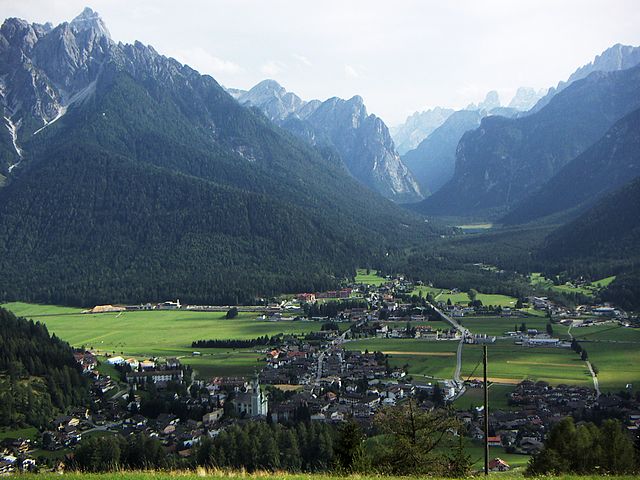
Брайес (Prags, Braies)
.svg)
- коммуна Италии
 Hiking in Брайес
Prags, or Braies, is a beautiful area located in the South Tyrol region of Italy, known for its stunning natural landscapes, particularly the Dolomite Mountains. The focal point of this area is the picturesque Lago di Braies (Pragser Wildsee), a striking alpine lake surrounded by imposing peaks and lush forests.
Hiking Opportunities:
-
Lake Braies Loop:
- Distance: Approximately 4 km (2.5 miles)
- Difficulty: Easy
- This relatively flat loop around the lake offers breathtaking views of the water and surrounding mountains. It's an excellent option for families and those looking for a leisurely hike.
-
Seekofel Hike:
- Distance: Roughly 10 km (6.2 miles) round trip
- Difficulty: Moderate
- This trail takes you up to the Seekofel, providing panoramic views of the Dolomites and the lake from above. It's a bit more challenging but the vistas make it worthwhile.
-
Hiking to the Dürrensee:
- Distance: Approximately 7 km (4.3 miles) one way
- Difficulty: Moderate
- This hike leads you to another beautiful lake, the Dürrensee, which is often less crowded and equally stunning.
Tips for Hiking in Prags:
- Season: The best time to hike is between late spring and early fall (May to September) when the trails are clear of snow and the weather is generally mild.
- Weather: Always check the weather forecast before heading out, as conditions can change quickly in the mountains.
- Footwear: Good hiking boots are essential, as some trails can be rocky and uneven.
- Water & Snacks: Carry enough water and snacks, as some trails may be longer than expected, and facilities along the route can be limited.
- Trail Markings: Follow the marked trails to ensure safety, and consider using a hiking app or map for navigation.
- Respect Nature: Stay on designated paths, pack out what you pack in, and be mindful of wildlife.
Other Activities:
Besides hiking, the area offers opportunities for other outdoor activities, such as climbing, mountain biking, and, in winter, skiing and snowshoeing. There are also charming local cafes and accommodation options for those looking to extend their stay and explore more of the region.
Overall, hiking in Prags combines natural beauty, varied terrain, and a peaceful atmosphere, making it a fantastic destination for outdoor enthusiasts.
- Страна:

- Почтовый код: 39030
- Телефонный код: 0474
- Код автомобильного номера: BZ
- Координаты: 46° 43' 0" N, 12° 8' 0" E


- GPS треки (wikiloc): [Ссылка]
- Высота над уровнем моря: 1213 м m
- Площадь: 90.25 кв.км
- Население: 652
- Веб сайт: http://www.gemeinde.prags.bz.it
- Википедия русская: wiki(ru)
- Википедия английская: wiki(en)
- Википедия национальная: wiki(it)
- Хранилище Wikidata: Wikidata: Q375618
- Галерея изображений в википедии: [Ссылка]
- Катеория в википедии: [Ссылка]
- код Freebase: [/m/0g9fx1]
- код GeoNames: Альт: [3181616]
- код VIAF: Альт: [159512608]
- ID отношения в OpenStreetMap: [47301]
- код GND: Альт: [4076319-5]
- код LCNAF: Альт: [n85152029]
- код ISTAT: 021009
- кадастровый код Италии: B116
Граничит с регионами:

Доббьяко
- коммуна Италии
Hiking in Доббьяко
Toblach, located in the South Tyrol region of northern Italy, is a beautiful destination for hikers, thanks to its stunning landscapes and well-marked trails. Here’s an overview of what you can expect when hiking in Toblach:...
- Страна:
- Почтовый код: 39034
- Телефонный код: 0474
- Код автомобильного номера: BZ
- Координаты: 46° 44' 7" N, 12° 13' 20" E
- GPS треки (wikiloc): [Ссылка]
- Высота над уровнем моря: 1241 м m
- Площадь: 125.42 кв.км
- Население: 3346
- Веб сайт: [Ссылка]


Кортина-д’Ампеццо
- коммуна Италии
Hiking in Кортина-д’Ампеццо
Cortina d'Ampezzo, located in the Veneto region of Italy, is a renowned destination for hiking enthusiasts, offering stunning landscapes, diverse trails, and breathtaking views of the Dolomites, a UNESCO World Heritage site. Here’s a guide to hiking in this beautiful area:...
- Страна:
- Почтовый код: 32043
- Телефонный код: 0436
- Код автомобильного номера: BL
- Координаты: 46° 32' 17" N, 12° 8' 14" E
- GPS треки (wikiloc): [Ссылка]
- Высота над уровнем моря: 1224 м m
- Площадь: 252.81 кв.км
- Население: 5852
- Веб сайт: [Ссылка]


Мареббе
- коммуна Италии
Hiking in Мареббе
Mareo is a charming area in the Asturias region of northern Spain, known for its breathtaking natural landscapes, rich biodiversity, and traditional villages. Hiking in Mareo can be a rewarding experience, offering various trails that cater to hikers of different skill levels. Here are a few key points to consider if you plan on hiking in this area:...
- Страна:
- Почтовый код: 39030
- Телефонный код: 0474
- Код автомобильного номера: BZ
- Координаты: 46° 43' 8" N, 11° 55' 1" E
- GPS треки (wikiloc): [Ссылка]
- Высота над уровнем моря: 1186 м m
- Площадь: 160.32 кв.км
- Население: 3037
- Веб сайт: [Ссылка]


Монгуэльфо-Тезидо
- коммуна Италии
Hiking in Монгуэльфо-Тезидо
Welsberg-Taisten is a beautiful hiking destination located in the South Tyrol region of northern Italy. Nestled in the Dolomites, it offers a wide range of hiking trails suitable for various skill levels, from easy strolls to challenging ascents. Here are some key points about hiking in this area:...
- Страна:
- Почтовый код: 39035
- Телефонный код: 0474
- Код автомобильного номера: BZ
- Координаты: 46° 45' 28" N, 12° 6' 20" E
- GPS треки (wikiloc): [Ссылка]
- Высота над уровнем моря: 1087 м m
- Площадь: 46.44 кв.км
- Население: 2867
- Веб сайт: [Ссылка]


Вальдаора
- коммуна в Италии
Hiking in Вальдаора
Olang, also known as Valdaora, is a picturesque village located in the South Tyrol region of northern Italy, nestled in the Dolomites. This area is renowned for its stunning landscapes, rich culture, and diverse hiking opportunities. Here's what you need to know about hiking in Olang:...
- Страна:
- Почтовый код: 39030
- Телефонный код: 0474
- Код автомобильного номера: BZ
- Координаты: 46° 45' 37" N, 12° 1' 46" E
- GPS треки (wikiloc): [Ссылка]
- Высота над уровнем моря: 1048 м m
- Площадь: 49.08 кв.км
- Население: 3174
- Веб сайт: [Ссылка]


Виллабасса
- коммуна в Италии
Hiking in Виллабасса
Niederdorf, located in the beautiful South Tyrol region of northern Italy, is a charming village surrounded by picturesque landscapes, making it a great destination for hiking enthusiasts. The area offers a variety of hiking trails that cater to different skill levels, from leisurely walks to challenging hikes....
- Страна:
- Почтовый код: 39039
- Телефонный код: 0474
- Код автомобильного номера: BZ
- Координаты: 46° 44' 16" N, 12° 10' 22" E
- GPS треки (wikiloc): [Ссылка]
- Высота над уровнем моря: 1154 м m
- Площадь: 18.03 кв.км
- Население: 1605
- Веб сайт: [Ссылка]