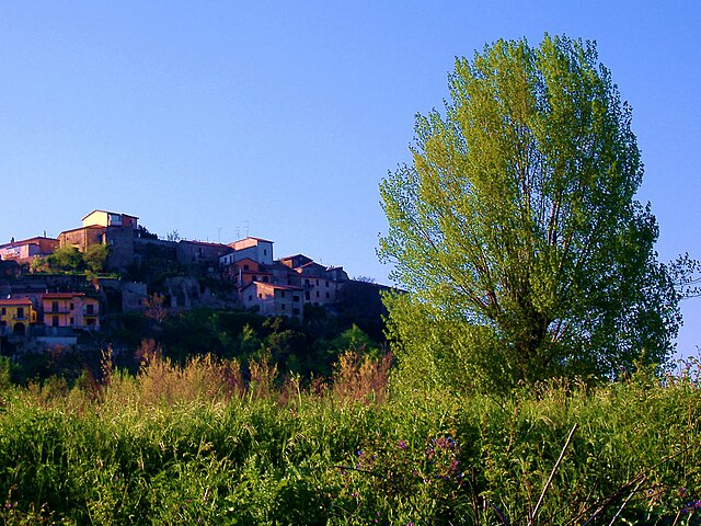
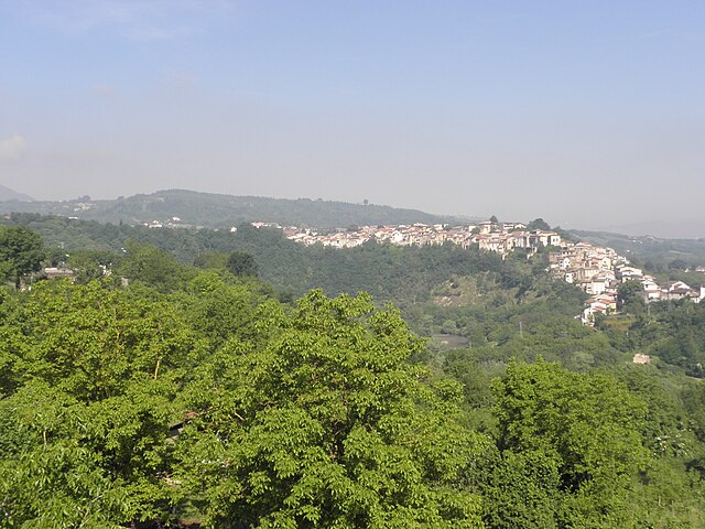
Пратола-Серра (Pratola Serra, Pratola Serra)
- коммуна Италии
 Hiking in Пратола-Серра
Pratola Serra is a charming town located in the province of Avellino in the Campania region of Italy. It is nestled in a mountainous area, making it an excellent location for hiking enthusiasts. Here are some details and tips for hiking in and around Pratola Serra:
Trails and Natural Attractions
-
Mount Partenio Regional Park: This park is close to Pratola Serra and offers several well-marked trails. The park is known for its diverse flora and fauna, beautiful landscapes, and panoramic views. Some popular trails lead to peaks like Monte Partenio, providing stunning vistas of the surrounding area.
-
Local Nature Trails: There are smaller trails and paths around Pratola Serra itself. These may take you through lush forests, olive groves, and quaint countryside. Exploring these paths can reveal beautiful hidden spots and local wildlife.
-
Historical Sites: While hiking, keep an eye out for historical landmarks. Some trails may lead to old churches, monasteries, or ruins that reflect the region's rich history.
Hiking Tips
- Weather Prep: Check the weather forecast before heading out; conditions can change rapidly in mountainous areas.
- Footwear: Wear appropriate hiking boots with good traction, as trails can be rocky and uneven.
- Hydration: Bring plenty of water, especially during the warmer months.
- Navigation: Carry a map or use a GPS device. While many trails are marked, it's always good to have a backup.
- Packing Snacks: Bringing some high-energy snacks can help keep your energy up while on the trails.
Best Time to Hike
The best times to hike in Pratola Serra are during the spring (April to June) and early autumn (September to October) when the weather is mild, and the area is lush with greenery.
Local Advice
Engage with local hiking groups or guides for insights into the best trails and current conditions. They can also help you discover less-known paths that may offer a more secluded experience.
Enjoy your hiking adventure in Pratola Serra! Whether you're looking for a challenging hike or a leisurely stroll, the natural beauty and serenity of the area are sure to impress.
- Страна:

- Почтовый код: 83039
- Телефонный код: 0825
- Код автомобильного номера: AV
- Координаты: 40° 59' 0" N, 14° 51' 0" E


- GPS треки (wikiloc): [Ссылка]
- Высота над уровнем моря: 280 м m
- Площадь: 8.84 кв.км
- Население: 3866
- Веб сайт: http://www.pratolaserra.gov.it/
- Википедия русская: wiki(ru)
- Википедия английская: wiki(en)
- Википедия национальная: wiki(it)
- Хранилище Wikidata: Wikidata: Q55082
- Катеория в википедии: [Ссылка]
- код Freebase: [/m/0fg0r9]
- код GeoNames: Альт: [6538792]
- код VIAF: Альт: [145857551]
- ID отношения в OpenStreetMap: [40959]
- UN/LOCODE: [ITVVS]
- код ISTAT: 064075
- кадастровый код Италии: H006
Граничит с регионами:
Кандида
- коммуна в Италии
Hiking in Кандида
Hiking in Candida, a small town in the Campania region of Italy, offers a delightful experience for nature lovers and outdoor enthusiasts. The area is part of the larger Irpinia region, known for its beautiful landscapes, rolling hills, and rich agricultural heritage. Here are some key points to consider about hiking in and around Candida:...
- Страна:
- Почтовый код: 83040
- Телефонный код: 0825
- Код автомобильного номера: AV
- Координаты: 40° 56' 36" N, 14° 52' 30" E
- GPS треки (wikiloc): [Ссылка]
- Высота над уровнем моря: 579 м m
- Площадь: 5.35 кв.км
- Население: 1121
- Веб сайт: [Ссылка]
Манокальцати
- коммуна Италии
Hiking in Манокальцати
Manocalzati is a charming town in the Campania region of Italy, located near the vibrant city of Avellino. While Manocalzati itself is not a major hiking destination, it offers access to several scenic trails and the surrounding areas that are ideal for hikers looking to explore the beautiful landscapes of the Irpinia region....
- Страна:
- Почтовый код: 83030
- Телефонный код: 0825
- Код автомобильного номера: AV
- Координаты: 40° 56' 33" N, 14° 51' 2" E
- GPS треки (wikiloc): [Ссылка]
- Высота над уровнем моря: 450 м m
- Площадь: 8.75 кв.км
- Население: 3198
- Веб сайт: [Ссылка]

Монтефальчоне
- коммуна Италии
Hiking in Монтефальчоне
Montefalcione, located in the Campania region of Italy, is a picturesque village set amidst the beautiful Apennine Mountains. Hiking in this area offers stunning landscapes, rich flora and fauna, and a glimpse into the local culture and traditions....
- Страна:
- Почтовый код: 83030
- Телефонный код: 0825
- Код автомобильного номера: AV
- Координаты: 40° 57' 45" N, 14° 53' 5" E
- GPS треки (wikiloc): [Ссылка]
- Высота над уровнем моря: 523 м m
- Площадь: 15.29 кв.км
- Население: 3285
- Веб сайт: [Ссылка]

Монтефредане
- коммуна Италии
Hiking in Монтефредане
Montefredane, located in the Campania region of Italy, is surrounded by beautiful landscapes and offers various hiking opportunities. Here are some key points about hiking in this area:...
- Страна:
- Почтовый код: 83030
- Телефонный код: 0825
- Код автомобильного номера: AV
- Координаты: 40° 58' 0" N, 14° 49' 0" E
- GPS треки (wikiloc): [Ссылка]
- Высота над уровнем моря: 593 м m
- Площадь: 9.45 кв.км
- Население: 2239
- Веб сайт: [Ссылка]
Монтемилетто
- коммуна Италии
Hiking in Монтемилетто
Montemiletto, located in the Campania region of Italy, is nestled in a picturesque area characterized by rolling hills and lush landscapes. While the area may not be as well-known as other hiking destinations in Italy, it offers several opportunities for outdoor enthusiasts to explore nature....
- Страна:
- Почтовый код: 83038
- Телефонный код: 0825
- Код автомобильного номера: AV
- Координаты: 41° 1' 0" N, 14° 54' 0" E
- GPS треки (wikiloc): [Ссылка]
- Высота над уровнем моря: 600 м m
- Площадь: 21.64 кв.км
- Население: 5288
- Веб сайт: [Ссылка]
Прата-ди-Принчипато-Ультра
- коммуна Италии
Hiking in Прата-ди-Принчипато-Ультра
Prata di Principato Ultra is a charming municipality located in the province of Avellino in the Campania region of Italy. Surrounded by the picturesque landscape of the Irpinia territory, it offers a variety of hiking opportunities that cater to different skill levels....
- Страна:
- Почтовый код: 83030
- Телефонный код: 0825
- Код автомобильного номера: AV
- Координаты: 40° 59' 0" N, 14° 50' 0" E
- GPS треки (wikiloc): [Ссылка]
- Высота над уровнем моря: 310 м m
- Площадь: 10.99 кв.км
- Население: 3040
- Веб сайт: [Ссылка]