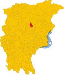
Премоло (Premolo, Premolo)
.svg)
- коммуна Италии
 Hiking in Премоло
Premolo is a charming village located in the Bergamo province in Lombardy, northern Italy. Nestled in the Seriana Valley, surrounded by the stunning Orobie Alps, it offers a variety of hiking opportunities for both beginners and experienced hikers.
Hiking Trails:
-
Valle di Scalve: A nearby region with trails that lead through beautiful forests and along alpine meadows, featuring breathtaking views of the surrounding mountains.
-
Sentiero dei Fiori: This is a scenic trail that showcases the diverse flora of the area. It’s ideal for those looking to enjoy nature and take in the local biodiversity.
-
Monte Misma: A more challenging hike that rewards trekkers with panoramic views. The ascent is steep in parts, and it’s best suited for those in good physical condition.
-
Parco dei Colli di Bergamo: Not far from Premolo, this park offers a variety of marked trails with varying levels of difficulty, suitable for all skill levels.
Tips for Hiking in Premolo:
-
Weather Check: Always check the weather conditions before heading out, as the mountain weather can change rapidly.
-
Proper Gear: Wear sturdy hiking boots and bring appropriate clothing layers, as temperatures can vary greatly.
-
Stay Hydrated: Carry enough water, especially on longer hikes, as some areas may lack drinking water sources.
-
Trail Maps: Make sure to have a trail map or use a GPS device, as some trails may not be well-marked.
-
Local Knowledge: Consider hiring a local guide if you want to explore lesser-known trails or if you’re unsure of the terrain.
What to Expect:
-
Breathtaking Views: Stunning vistas of the Orobie Alps and lush landscapes.
-
Wildlife: The area is home to a variety of wildlife, including deer, eagles, and numerous bird species.
-
Cultural Experience: Discover local traditions and possibly visit small chapels and historical sites along the trails.
Hiking in Premolo offers a wonderful blend of natural beauty, physical challenge, and cultural experience, making it an excellent choice for outdoor enthusiasts. Whether you’re there for a day hike or planning a longer trekking adventure, you're sure to enjoy the breathtaking scenery and peaceful atmosphere.
- Страна:

- Почтовый код: 24020
- Телефонный код: 035
- Код автомобильного номера: BG
- Координаты: 45° 52' 0" N, 9° 53' 0" E


- GPS треки (wikiloc): [Ссылка]
- Высота над уровнем моря: 625 м m
- Площадь: 17.63 кв.км
- Население: 1122
- Веб сайт: http://www.comune.premolo.bg.it/
- Википедия русская: wiki(ru)
- Википедия английская: wiki(en)
- Википедия национальная: wiki(it)
- Хранилище Wikidata: Wikidata: Q101477
- Галерея изображений в википедии: [Ссылка]
- Катеория в википедии: [Ссылка]
- код Freebase: [/m/0gjd2j]
- код GeoNames: Альт: [6542958]
- код VIAF: Альт: [245454081]
- ID отношения в OpenStreetMap: [46387]
- код ISTAT: 016175
- кадастровый код Италии: H036
Граничит с регионами:

Горно
- коммуна Италии
Hiking in Горно
Gorno is a small town in Bulgaria, located in the Pirin Mountains, which offers a variety of hiking opportunities for all levels of hikers. Here are some key points and tips for hiking in and around Gorno:...
- Страна:
- Почтовый код: 24020
- Телефонный код: 035
- Код автомобильного номера: BG
- Координаты: 45° 52' 0" N, 9° 50' 0" E
- GPS треки (wikiloc): [Ссылка]
- Высота над уровнем моря: 710 м m
- Площадь: 10 кв.км
- Население: 1580
- Веб сайт: [Ссылка]


Ольтре-иль-Колле
- коммуна Италии
Hiking in Ольтре-иль-Колле
Oltre il Colle is a beautiful destination for hiking enthusiasts, located in the Seriana Valley in Italy, close to Bergamo. Known for its stunning landscapes, the area offers a range of trails suitable for various skill levels, from leisurely walks to more challenging hikes....
- Страна:
- Почтовый код: 24013
- Телефонный код: 0345
- Код автомобильного номера: BG
- Координаты: 45° 53' 0" N, 9° 46' 0" E
- GPS треки (wikiloc): [Ссылка]
- Высота над уровнем моря: 1030 м m
- Площадь: 32.89 кв.км
- Население: 1004
- Веб сайт: [Ссылка]


Онета
- коммуна Италии
Hiking in Онета
Oneta, located in the Lombardy region of Italy, is a picturesque village nestled within the Orobian Alps, making it an excellent spot for hiking enthusiasts. The area boasts stunning landscapes, including lush forests, rocky terrains, and panoramic views of the surrounding mountains....
- Страна:
- Почтовый код: 24020
- Телефонный код: 035
- Код автомобильного номера: BG
- Координаты: 45° 52' 0" N, 9° 49' 0" E
- GPS треки (wikiloc): [Ссылка]
- Высота над уровнем моря: 740 м m
- Площадь: 18.66 кв.км
- Население: 598
- Веб сайт: [Ссылка]


Парре
- коммуна Италии
Hiking in Парре
Parre, a small town in the province of Bergamo, Italy, offers a charming backdrop for hikers with its stunning landscapes, picturesque views, and various trails. It's nestled in the Seriana Valley, surrounded by the captivating Orobie Mountains, which provide ample hiking opportunities for enthusiasts of all levels....
- Страна:
- Почтовый код: 24020
- Телефонный код: 035
- Код автомобильного номера: BG
- Координаты: 45° 52' 0" N, 9° 54' 0" E
- GPS треки (wikiloc): [Ссылка]
- Высота над уровнем моря: 650 м m
- Площадь: 22.28 кв.км
- Население: 2732
- Веб сайт: [Ссылка]


Понте-Носса
- коммуна Италии
Hiking in Понте-Носса
Ponte Nossa is a picturesque town located in the Lombardy region of northern Italy, part of the Bergamo province. Surrounded by the stunning Orobie Alps, it offers a variety of hiking opportunities, making it an excellent destination for both novice and experienced hikers....
- Страна:
- Почтовый код: 24028
- Телефонный код: 035
- Код автомобильного номера: BG
- Координаты: 45° 52' 0" N, 9° 53' 0" E
- GPS треки (wikiloc): [Ссылка]
- Высота над уровнем моря: 465 м m
- Площадь: 5.59 кв.км
- Население: 1761
- Веб сайт: [Ссылка]


Ардезьо
- коммуна Италии
Hiking in Ардезьо
Ardesio, located in the Seriana Valley in the Lombardy region of Italy, offers a variety of hiking opportunities for both beginners and experienced hikers. The area is characterized by its stunning landscapes, including lush forests, rocky terrains, and panoramic views of the surrounding mountains....
- Страна:
- Почтовый код: 24020
- Телефонный код: 0346
- Код автомобильного номера: BG
- Координаты: 45° 56' 17" N, 9° 55' 48" E
- GPS треки (wikiloc): [Ссылка]
- Высота над уровнем моря: 608 м m
- Площадь: 54.44 кв.км
- Население: 3485
- Веб сайт: [Ссылка]