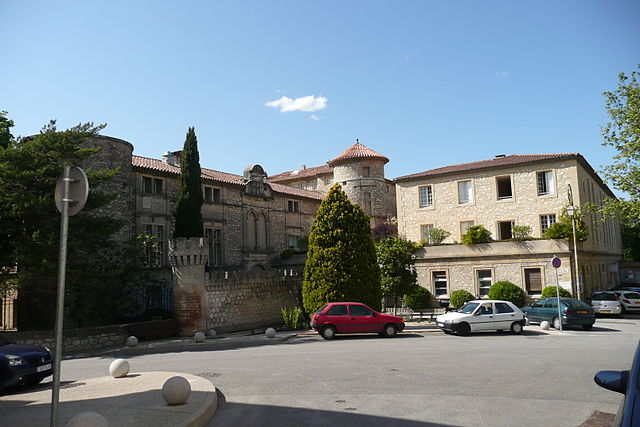
Пюже (Puget, Puget)

 Hiking in Пюже
Hiking in the Puget Sound region of Washington State offers an incredible variety of trails and stunning scenery, ranging from coastal walks to mountainous terrains. The region's diverse ecosystems provide opportunities to explore lush forests, alpine lakes, and vibrant wildlife. Here are some highlights:
Key Areas for Hiking in the Puget Sound Region:
-
Olympic National Park:
- Features a mix of ecosystems, including rainforests, coastlines, and mountains.
- Popular hikes include the Hoh Rain Forest, Hurricane Ridge, and the Enchanted Valley.
-
Mount Rainier National Park:
- Home to Washington's highest peak, Mount Rainier.
- Trails such as the Skyline Trail and Kautz Creek offer breathtaking views of glaciers and wildflower meadows.
-
Snoqualmie Pass:
- Offers numerous hiking trails, including the popular Rattlesnake Ledge and Denny Creek.
- Great for both day hikes and longer backpacking trips.
-
North Cascades National Park:
- Known for rugged mountains and deep valleys.
- Trails like Cascade Pass and Park Butte lead to spectacular views and access to alpine lakes.
-
Washington State Parks:
- Numerous parks around the Puget Sound like Deception Pass State Park and Fort Flagler State Park offer beautiful coastal hikes with scenic vistas.
-
Local Trails:
- Many urban parks in cities like Seattle and Tacoma have excellent trails. The Burke-Gilman Trail and Discovery Park in Seattle are popular for both walking and biking.
Hiking Tips:
- Plan Ahead: Research trail conditions, weather, and difficulty level to ensure a safe and enjoyable hike.
- Pack Essentials: Carry enough water, snacks, a first aid kit, map or GPS, and appropriate clothing for changing conditions.
- Leave No Trace: Follow principles of Leave No Trace to preserve the natural beauty of the area.
- Wildlife Awareness: Be aware of local wildlife and know how to react in encounters with animals like bears or cougars.
Best Time to Hike:
- Spring (April - June): Wildflowers bloom, and the weather starts to warm, making this a great time for lower elevation hikes.
- Summer (July - September): The most popular time for hiking, with dry trails and clear skies. However, some trails may be crowded.
- Fall (October): Beautiful autumn colors and cooler temperatures make for a lovely hiking experience. Be mindful of shorter days.
- Winter (November - March): Some trails are accessible for winter hiking but be prepared for snow and potentially challenging conditions.
With its stunning natural landscapes and numerous trails, the Puget Sound region is a hiker's paradise.
- Страна:

- Почтовый код: 84360
- Координаты: 43° 45' 18" N, 5° 16' 9" E


- GPS треки (wikiloc): [Ссылка]
- Площадь: 17.9 кв.км
- Население: 735
- Википедия русская: wiki(ru)
- Хранилище Wikidata: Wikidata: Q470881
- Катеория в википедии: [Ссылка]
- код Freebase: [/m/025_v6f]
- код GeoNames: Альт: [2985146]
- номер SIREN: [218400935]
- код BNF: [15278073s]
- код LCNAF: Альт: [n96102041]
- код муниципалитета INSEE: 84093
Граничит с регионами:


Шарлеваль
- Коммуна в департаменте Буш-дю-Рон (Франция)
Hiking in Шарлеваль
Charleval, located in the Bouches-du-Rhône department in the south of France, offers beautiful hiking opportunities amidst stunning natural landscapes. Here are some key points about hiking in Charleval:...
- Страна:
- Почтовый код: 13350
- Координаты: 43° 43' 7" N, 5° 14' 44" E
- GPS треки (wikiloc): [Ссылка]
- Площадь: 14.41 кв.км
- Население: 2731
- Веб сайт: [Ссылка]


Мерендоль
- коммуна во Франции
Hiking in Мерендоль
Mérindol, located in the Provence region of France, is a picturesque village surrounded by beautiful landscapes, making it a delightful destination for hiking enthusiasts. The area is characterized by its rolling hills, vineyards, and stunning views of the Luberon Mountains, which provides various trails suitable for different skill levels....
- Страна:
- Почтовый код: 84360
- Координаты: 43° 45' 21" N, 5° 12' 11" E
- GPS треки (wikiloc): [Ссылка]
- Площадь: 26.59 кв.км
- Население: 2023


Менерб
Hiking in Менерб
Ménerbes is a picturesque village located in the Luberon region of Provence, France. It's known for its charming stone architecture, stunning views, and rich history. Hiking around Ménerbes offers a wonderful combination of scenic landscapes, vineyards, and historical sites. Here are some key points to consider when planning a hike in this area:...
- Страна:
- Почтовый код: 84560
- Координаты: 43° 49' 56" N, 5° 12' 23" E
- GPS треки (wikiloc): [Ссылка]
- Высота над уровнем моря: 244 м m
- Площадь: 30.27 кв.км
- Население: 995
- Веб сайт: [Ссылка]


Лори
- коммуна во Франции
Hiking in Лори
Lauris is a picturesque village located in the Provence-Alpes-Côte d'Azur region of France, known for its stunning landscapes, charming architecture, and rich history. It sits at the foot of the Luberon mountains, making it an excellent base for hikers looking to explore the natural beauty of the area. Here are some key points to consider when hiking in Lauris:...
- Страна:
- Почтовый код: 84360
- Координаты: 43° 44' 49" N, 5° 18' 48" E
- GPS треки (wikiloc): [Ссылка]
- Площадь: 21.81 кв.км
- Население: 3789
- Веб сайт: [Ссылка]


Мальмор
- коммуна во Франции
Hiking in Мальмор
Mallemort, located in the Provence-Alpes-Côte d'Azur region of France, offers a variety of beautiful landscapes for hiking enthusiasts. The region is characterized by its rolling hills, vineyards, and picturesque views, making it an attractive destination for outdoor activities....
- Страна:
- Почтовый код: 13370
- Координаты: 43° 43' 51" N, 5° 10' 46" E
- GPS треки (wikiloc): [Ссылка]
- Площадь: 28.16 кв.км
- Население: 5880
- Веб сайт: [Ссылка]


Лакост
Hiking in Лакост
Lacoste, located in the Vaucluse region of France, is a charming village in the Luberon area, known for its picturesque landscapes, historic buildings, and stunning views of the surrounding countryside. Hiking in and around Lacoste offers a wonderful opportunity to explore the natural beauty of Provence while immersing yourself in its rich history....
- Страна:
- Почтовый код: 84480
- Координаты: 43° 49' 56" N, 5° 16' 24" E
- GPS треки (wikiloc): [Ссылка]
- Площадь: 10.66 кв.км
- Население: 409
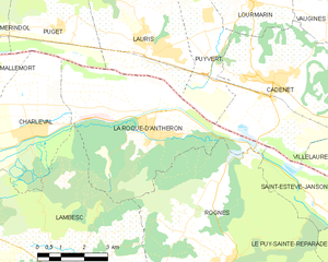
Ла-Рок-д’Антерон
- коммуна во Франции
Hiking in Ла-Рок-д’Антерон
La Roque-d'Anthéron is a charming village located in the Provence-Alpes-Côte d'Azur region of France, nestled in the heart of the Luberon Valley. Known for its scenic landscapes, rich history, and vibrant flora and fauna, it's a great base for hikers looking to explore the beautiful terrain....
- Страна:
- Почтовый код: 13640
- Координаты: 43° 42' 53" N, 5° 18' 39" E
- GPS треки (wikiloc): [Ссылка]
- Площадь: 25.49 кв.км
- Население: 5469
- Веб сайт: [Ссылка]