Пюимуассон (Puimoisson, Puimoisson)
- коммуна во Франции
 Hiking in Пюимуассон
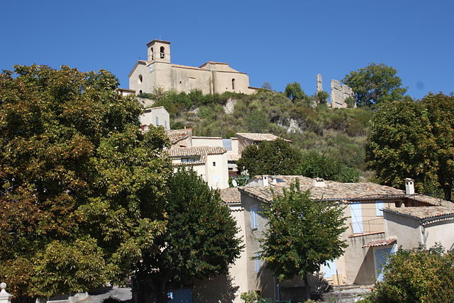
Puimoisson is a small commune located in the Alpes-de-Haute-Provence department in southeastern France. Nestled in the picturesque landscape of Provence, it offers stunning views, diverse terrain, and a rich natural environment, making it a great destination for hiking enthusiasts.
Hiking Trails
-
Local Trails: There are several well-marked trails around Puimoisson that cater to various skill levels. These trails often take you through beautiful forests, rolling hills, and offer panoramic views of the surrounding countryside.
-
Nearby Natural Parks: Puimoisson is close to the Verdon Regional Natural Park, renowned for its dramatic gorges and stunning landscapes. Trails here range from easy walks to more challenging hikes, allowing for exploration of the area's natural beauty.
-
Lavender Fields: In the summer months, hiking around Puimoisson can offer views of the vibrant lavender fields that Provence is famous for. This is a picturesque experience and ideal for photography.
Important Considerations
-
Weather: The weather can vary by season, so check the forecast and plan accordingly. Summers can be hot, while spring and autumn may provide more favorable conditions for hiking.
-
Gear: Make sure to wear proper hiking boots and take sufficient water, especially for longer hikes. A map or GPS can also be helpful in the less marked areas.
-
Wildlife: Keep an eye out for local wildlife, including various bird species and perhaps the occasional deer.
-
Local Culture: Take some time to explore the local culture and quit the hike early to enjoy a meal at one of the local cafés or restaurants.
Conclusion
Hiking in and around Puimoisson can be a delightful experience, combining both the beauty of nature and the rich culture of Provence. With its stunning landscapes and variety of trails, it’s an excellent location for both novice and experienced hikers. Always remember to respect the natural environment and enjoy the tranquility that this beautiful area has to offer.
- Страна:

- Почтовый код: 04410
- Координаты: 43° 51' 46" N, 6° 7' 38" E


- GPS треки (wikiloc): [Ссылка]
- Площадь: 35.44 кв.км
- Население: 748
- Википедия русская: wiki(ru)
- Википедия английская: wiki(en)
- Википедия национальная: wiki(fr)
- Хранилище Wikidata: Wikidata: Q1017934
- Катеория в википедии: [Ссылка]
- код Freebase: [/m/03m7x69]
- код Freebase: [/m/03m7x69]
- код GeoNames: Альт: [2985122]
- код GeoNames: Альт: [2985122]
- номер SIREN: [210401576]
- номер SIREN: [210401576]
- WOEID: [618272]
- WOEID: [618272]
- код муниципалитета INSEE: 04157
- код муниципалитета INSEE: 04157
Граничит с регионами:

Сен-Жюльен-д’Ас
- коммуна во Франции
Hiking in Сен-Жюльен-д’Ас
Saint-Julien-d'Asse is a charming commune in the Alpes-de-Haute-Provence region of southeastern France. It's surrounded by picturesque landscapes, offering a variety of hiking opportunities for outdoor enthusiasts. Here are some key points to consider if you're planning to hike in this area:...
- Страна:
- Почтовый код: 04270
- Координаты: 43° 55' 2" N, 6° 5' 39" E
- GPS треки (wikiloc): [Ссылка]
- Площадь: 25.6 кв.км
- Население: 196

Мутье-Сент-Мари
- коммуна во Франции
Hiking in Мутье-Сент-Мари
Moustiers-Sainte-Marie is a beautiful village in the Provence-Alpes-Côte d'Azur region of southeastern France, known for its stunning scenery and outdoor activities, particularly hiking. It’s nestled near the Gorges du Verdon, often referred to as the Grand Canyon of Europe, which offers a plethora of hiking trails ranging from easy strolls to more challenging treks....
- Страна:
- Почтовый код: 04360
- Координаты: 43° 50' 51" N, 6° 13' 16" E
- GPS треки (wikiloc): [Ссылка]
- Высота над уровнем моря: 1729 м m
- Площадь: 87.97 кв.км
- Население: 693
- Веб сайт: [Ссылка]

Рье
- коммуна во Франции
Hiking in Рье
Riez, a charming village in the Alpes-de-Haute-Provence region of southeastern France, offers a variety of hiking opportunities that showcase the natural beauty and historical significance of the area. Here are some details and tips for hiking in and around Riez:...
- Страна:
- Почтовый код: 04500
- Координаты: 43° 49' 5" N, 6° 5' 34" E
- GPS треки (wikiloc): [Ссылка]
- Площадь: 40 кв.км
- Население: 1828
- Веб сайт: [Ссылка]
Сен-Жюр
- коммуна во Франции
Hiking in Сен-Жюр
Saint-Jurs, a small village in the Alpes-de-Haute-Provence region of France, offers a variety of hiking opportunities for outdoor enthusiasts. Nestled in a picturesque setting, the area is characterized by stunning landscapes, rolling hills, and scenic views of the surrounding mountains....
- Страна:
- Почтовый код: 04410
- Координаты: 43° 53' 55" N, 6° 11' 59" E
- GPS треки (wikiloc): [Ссылка]
- Высота над уровнем моря: 925 м m
- Площадь: 33.59 кв.км
- Население: 139

Румуль
- коммуна во Франции
Hiking in Румуль
Roumoules is a charming village located in the Alpes-de-Haute-Provence region of France. It serves as a great base for outdoor enthusiasts looking to explore the stunning landscapes of this part of Provence....
- Страна:
- Почтовый код: 04500
- Координаты: 43° 49' 32" N, 6° 7' 48" E
- GPS треки (wikiloc): [Ссылка]
- Площадь: 26.04 кв.км
- Население: 746

Бра-д’Асс
- коммуна во Франции
Hiking in Бра-д’Асс
Bras-d'Asse is a charming small village located in the Alpes-de-Haute-Provence region of France. It's nestled in a scenic area known for its stunning natural landscapes, which makes it a lovely destination for hiking enthusiasts. Here are some key points to consider if you're planning a hiking trip to Bras-d'Asse:...
- Страна:
- Почтовый код: 04270
- Координаты: 43° 55' 32" N, 6° 7' 32" E
- GPS треки (wikiloc): [Ссылка]
- Высота над уровнем моря: 633 м m
- Площадь: 26.1 кв.км
- Население: 580
- Веб сайт: [Ссылка]

Брюне
- коммуна во Франции
Hiking in Брюне
Brunet, located in the Alpes-de-Haute-Provence region of France, offers a unique hiking experience with its stunning landscapes and diverse natural features. Here are some highlights and tips for hiking in this beautiful area:...
- Страна:
- Почтовый код: 04210
- Координаты: 43° 53' 29" N, 6° 1' 49" E
- GPS треки (wikiloc): [Ссылка]
- Площадь: 28.47 кв.км
- Население: 255