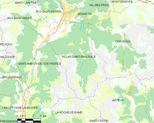
Пюи-Сент-Андре (Puy-Saint-André, Puy-Saint-André)
- коммуна во Франции
 Hiking in Пюи-Сент-Андре
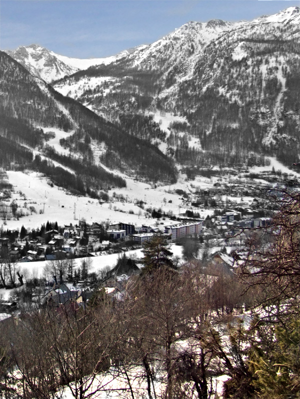
Puy-Saint-André is a charming village located in the Hautes-Alpes region of southeastern France, and it serves as a wonderful base for hiking enthusiasts. Nestled near the Écrins National Park, the area boasts stunning alpine scenery, diverse flora and fauna, and a range of trails suitable for various skill levels.
Hiking Highlights in Puy-Saint-André:
-
Trail Diversity: The region offers trails for all levels, from easy strolls through picturesque meadows to more challenging routes that lead to higher altitudes. Whether you're a beginner or an experienced hiker, you can find a suitable path.
-
Scenic Views: Many trails provide breathtaking views of the surrounding mountains, including the iconic peaks of the Écrins massif. As you hike, you'll encounter stunning landscapes, waterfalls, and possibly even wildlife such as chamois or marmots.
-
The GR54 Route: One of the most notable longer trails in the area is part of the Grande Randonnée (GR) network, particularly the GR54, which circumnavigates the Écrins National Park. This route takes you through diverse landscapes and can be tackled in sections.
-
Local Flora and Fauna: The area around Puy-Saint-André is rich in biodiversity. Depending on the season, you can see a variety of wildflowers and alpine plants as well as animals native to the region.
-
Cultural Aspects: While hiking, you might also encounter traditional alpine architecture and local villages, which can enhance your cultural experience as you explore the area.
Tips for Hiking in Puy-Saint-André:
-
Season Considerations: The best time for hiking in this region is late spring through early autumn (May to October), when trails are usually accessible and the weather is more favorable.
-
Trail Map: Always carry a detailed map or a GPS device, as some trails may not be well-marked. Local tourism offices may provide maps or recommend guided hikes.
-
Prepare for Weather: Weather in the mountains can change rapidly, so it's important to dress in layers and bring waterproof gear. Always check the weather forecast before heading out.
-
Hydration and Nutrition: Carry enough water and snacks, especially for longer hikes. There may not be available resources along the trails.
-
Respect Nature: Follow Leave No Trace principles to preserve the beauty of the environment. Stay on marked trails and dispose of waste properly.
Whether you're looking for a peaceful walk or an adventurous trek, Puy-Saint-André and its surrounding area provide a fantastic hiking experience. Enjoy your time exploring the stunning landscapes!
- Страна:

- Почтовый код: 05100
- Координаты: 44° 52' 44" N, 6° 35' 55" E


- GPS треки (wikiloc): [Ссылка]
- Площадь: 15.37 кв.км
- Население: 466
- Википедия русская: wiki(ru)
- Википедия английская: wiki(en)
- Википедия национальная: wiki(fr)
- Хранилище Wikidata: Wikidata: Q1086230
- Катеория в википедии: [Ссылка]
- код Freebase: [/m/03mfppk]
- код Freebase: [/m/03mfppk]
- код GeoNames: Альт: [6425610]
- код GeoNames: Альт: [6425610]
- номер SIREN: [210501078]
- номер SIREN: [210501078]
- код VIAF: Альт: [248704519]
- код VIAF: Альт: [248704519]
- код муниципалитета INSEE: 05107
- код муниципалитета INSEE: 05107
Граничит с регионами:

Сен-Шафре
- коммуна во Франции
Hiking in Сен-Шафре
Saint-Chaffrey is a charming commune located in the Hautes-Alpes region of France, and it's part of the broader area known for its stunning alpine scenery and outdoor activities, particularly hiking. Here are some key points about hiking in and around Saint-Chaffrey:...
- Страна:
- Почтовый код: 05330
- Координаты: 44° 55' 34" N, 6° 36' 24" E
- GPS треки (wikiloc): [Ссылка]
- Площадь: 25.88 кв.км
- Население: 1643
- Веб сайт: [Ссылка]

Пюи-Сен-Пьер
- коммуна во Франции
Hiking in Пюи-Сен-Пьер
Puy-Saint-Pierre is a charming commune located in the Hautes-Alpes region of southeastern France. It's surrounded by stunning landscapes and offers a range of hiking opportunities, perfect for both beginner and experienced hikers. Here are some highlights about hiking in Puy-Saint-Pierre:...
- Страна:
- Почтовый код: 05100
- Координаты: 44° 53' 27" N, 6° 37' 26" E
- GPS треки (wikiloc): [Ссылка]
- Площадь: 7.74 кв.км
- Население: 529

Пельву
- коммуна во Франции
Hiking in Пельву
Pelvoux is a beautiful region located in the French Alps, specifically in the Ecrins National Park. It's known for its stunning mountain landscapes, varied hiking trails, and breathtaking views. Here are some key points to keep in mind when planning a hiking trip to Pelvoux:...
- Страна:
- Почтовый код: 05340
- Координаты: 44° 52' 9" N, 6° 29' 12" E
- GPS треки (wikiloc): [Ссылка]
- Площадь: 76.23 кв.км
- Население: 483

Сен-Мартен-де-Кейриер
- коммуна во Франции
Hiking in Сен-Мартен-де-Кейриер
Saint-Martin-de-Queyrières is a charming village located in the Hautes-Alpes region of France. It's a fantastic starting point for hiking enthusiasts as it offers access to stunning landscapes, diverse trails, and beautiful views of the Écrins National Park and surrounding mountains. Here are some highlights regarding hiking in this area:...
- Страна:
- Почтовый код: 05120
- Координаты: 44° 50' 25" N, 6° 35' 7" E
- GPS треки (wikiloc): [Ссылка]
- Высота над уровнем моря: 1200 м m
- Площадь: 55.52 кв.км
- Население: 1131

Бриансон
- коммуна во Франции
Hiking in Бриансон
Briançon, located in the French Alps, is renowned for its stunning natural beauty and rich history. It sits at an elevation of about 1,326 meters (4,347 feet) and is surrounded by impressive mountain ranges, making it an ideal destination for hiking enthusiasts....
- Страна:
- Почтовый код: 05100
- Координаты: 44° 53' 45" N, 6° 38' 6" E
- GPS треки (wikiloc): [Ссылка]
- Высота над уровнем моря: 1325 м m
- Площадь: 28.07 кв.км
- Население: 12370
- Веб сайт: [Ссылка]

Виллар-Сен-Панкрас
- коммуна во Франции
Hiking in Виллар-Сен-Панкрас
Villar-Saint-Pancrace is a charming alpine village located in the Provence-Alpes-Côte d'Azur region of France, near the town of Briançon. The area is known for its stunning landscapes, rich biodiversity, and a variety of hiking trails that cater to different skill levels. Here are some highlights for hiking in this region:...
- Страна:
- Почтовый код: 05100
- Координаты: 44° 52' 23" N, 6° 37' 38" E
- GPS треки (wikiloc): [Ссылка]
- Высота над уровнем моря: 1260 м m
- Площадь: 42.53 кв.км
- Население: 1457
Ла-Саль-лез-Альп
- коммуна во Франции
Hiking in Ла-Саль-лез-Альп
La Salle-les-Alpes, located in the Hautes-Alpes region of southeastern France, is a fantastic destination for hiking enthusiasts. Nestled in the enchanting Écrins National Park, this charming village offers breathtaking mountain views, diverse landscapes, and a variety of trails suited for all skill levels....
- Страна:
- Почтовый код: 05240
- Координаты: 44° 56' 41" N, 6° 34' 15" E
- GPS треки (wikiloc): [Ссылка]
- Высота над уровнем моря: 1397 м m
- Площадь: 35.42 кв.км
- Население: 1003