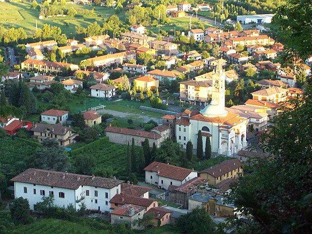
Раника (Ranica, Ranica)
.svg)
- коммуна Италии
 Hiking in Раника
Ranica is a picturesque area located in Italy, known for its stunning natural landscapes, making it a great destination for hiking enthusiasts. Here are some key points to consider if you’re planning to hike in Ranica:
Trails and Terrain
- Scenic Views: The region offers a variety of trails ranging from easy walks to more challenging hikes, all characterized by beautiful views of the surrounding mountains and valleys.
- Difficulty Levels: It's essential to choose trails that match your fitness level. Some paths may be suitable for beginners, while others might require more experience and physical endurance.
- Well-Marketed Trails: Look for marked paths in the area. Local guides and maps can help you navigate the terrain safely.
Best Hikes
- Local Parks and Nature Reserves: Check for nearby parks which often have designated trails. These spots typically have well-maintained paths and offer chances to see local wildlife.
- Mountain Ascents: If you're more experienced, look for trails that lead to mountain summits for breathtaking panoramic views.
Gear and Preparation
- Proper Footwear: Invest in good hiking boots to ensure comfort and safety on uneven terrain.
- Weather Considerations: Check the weather forecast before you go. Conditions can change quickly in mountainous areas.
- Hydration and Snacks: Carry enough water and energy snacks, especially if you plan on longer hikes.
Safety
- Stay on Marked Trails: To avoid getting lost and to minimize environmental impact, always stick to marked paths.
- Travel in Groups: If possible, hike with others for safety and companionship.
- Emergency Kit: Carry a basic first aid kit, a map, and a compass or a reliable GPS device.
Other Activities
In addition to hiking, you may find opportunities for bird watching, photography, and enjoying the local flora and fauna. After a day of hiking, explore the local cuisine and culture to enrich your experience.
Conclusion
Hiking in Ranica offers a fantastic way to connect with nature and enjoy the outdoors. Whether you're a beginner or an experienced hiker, the trails in this beautiful area have something to offer everyone. Always plan ahead and prioritize safety for an enjoyable hiking experience!
- Страна:

- Почтовый код: 24020
- Телефонный код: 035
- Код автомобильного номера: BG
- Координаты: 45° 44' 0" N, 9° 43' 0" E


- GPS треки (wikiloc): [Ссылка]
- Высота над уровнем моря: 293 м m
- Площадь: 4.06 кв.км
- Население: 5945
- Веб сайт: http://www.comune.ranica.bg.it
- Википедия русская: wiki(ru)
- Википедия английская: wiki(en)
- Википедия национальная: wiki(it)
- Хранилище Wikidata: Wikidata: Q101500
- Галерея изображений в википедии: [Ссылка]
- Катеория в википедии: [Ссылка]
- код Freebase: [/m/0gjd6r]
- код GeoNames: Альт: [6543757]
- код VIAF: Альт: [241258188]
- ID отношения в OpenStreetMap: [45850]
- UN/LOCODE: [ITIRN]
- код ISTAT: 016178
- кадастровый код Италии: H176
Граничит с регионами:


Горле
- коммуна Италии
Hiking in Горле
Gorle, a small municipality in the Lombardy region of Italy, is located near the city of Bergamo. While it's not as internationally renowned for hiking as some of its neighboring regions, it still offers opportunities for outdoor activities in a picturesque setting....
- Страна:
- Почтовый код: 24020
- Телефонный код: 035
- Код автомобильного номера: BG
- Координаты: 45° 42' 14" N, 9° 43' 9" E
- GPS треки (wikiloc): [Ссылка]
- Высота над уровнем моря: 268 м m
- Площадь: 2.52 кв.км
- Население: 6557
- Веб сайт: [Ссылка]


Понтераника
- коммуна Италии
Hiking in Понтераника
Ponteranica is a charming community situated in the Lombardy region of Italy, near the city of Bergamo. The area is known for its beautiful landscapes, lush forests, and proximity to the Orobie Alps, making it an excellent destination for hiking enthusiasts. Here's what you should know about hiking in and around Ponteranica:...
- Страна:
- Почтовый код: 24010
- Телефонный код: 035
- Код автомобильного номера: BG
- Координаты: 45° 44' 0" N, 9° 39' 0" E
- GPS треки (wikiloc): [Ссылка]
- Высота над уровнем моря: 545 м m
- Площадь: 8.48 кв.км
- Население: 6862
- Веб сайт: [Ссылка]

Сканцорошате
- коммуна Италии
Hiking in Сканцорошате
Scanzorosciate is a charming town located in the Lombardy region of northern Italy, near the city of Bergamo. The area offers a variety of hiking opportunities that allow you to explore its stunning landscapes, nature, and cultural heritage....
- Страна:
- Почтовый код: 24020
- Телефонный код: 035
- Код автомобильного номера: BG
- Координаты: 45° 42' 41" N, 9° 44' 9" E
- GPS треки (wikiloc): [Ссылка]
- Высота над уровнем моря: 297 м m
- Площадь: 10.69 кв.км
- Население: 10076
- Веб сайт: [Ссылка]


Торре-Больдоне
- коммуна Италии
Hiking in Торре-Больдоне
Torre Boldone is a charming municipality located in the province of Bergamo in Lombardy, Italy. Nestled at the foothills of the beautiful Alps, it offers diverse hiking opportunities that cater to various skill levels....
- Страна:
- Почтовый код: 24020
- Телефонный код: 035
- Код автомобильного номера: BG
- Координаты: 45° 43' 0" N, 9° 42' 0" E
- GPS треки (wikiloc): [Ссылка]
- Высота над уровнем моря: 280 м m
- Площадь: 3.48 кв.км
- Население: 8755
- Веб сайт: [Ссылка]


Вилла-ди-Серио
- коммуна Италии
Hiking in Вилла-ди-Серио
Villa di Serio is a charming area located in the province of Bergamo in northern Italy, surrounded by beautiful landscapes and nature, making it a great destination for hiking enthusiasts. Here are some details about hiking opportunities in and around Villa di Serio:...
- Страна:
- Почтовый код: 24020
- Телефонный код: 035
- Код автомобильного номера: BG
- Координаты: 45° 43' 18" N, 9° 44' 6" E
- GPS треки (wikiloc): [Ссылка]
- Высота над уровнем моря: 275 м m
- Площадь: 4.6 кв.км
- Население: 6777
- Веб сайт: [Ссылка]

Альцано-Ломбардо
- коммуна Италии
Hiking in Альцано-Ломбардо
Alzano Lombardo is a charming town located in the Lombardy region of Italy, nestled near the foothills of the Bergamasque Alps. The area offers various hiking opportunities that cater to different skill levels and preferences. Here are some highlights of hiking in and around Alzano Lombardo:...
- Страна:
- Почтовый код: 24022
- Телефонный код: 035
- Код автомобильного номера: BG
- Координаты: 45° 43' 54" N, 9° 43' 42" E
- GPS треки (wikiloc): [Ссылка]
- Высота над уровнем моря: 304 м m
- Площадь: 13.68 кв.км
- Население: 13637
- Веб сайт: [Ссылка]