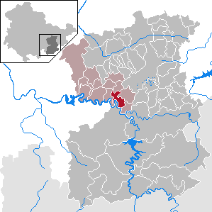
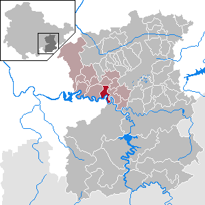
Ранис-Цигенрюк (Ranis-Ziegenrück, Verwaltungsgemeinschaft Ranis-Ziegenrück)
 Hiking in Ранис-Цигенрюк
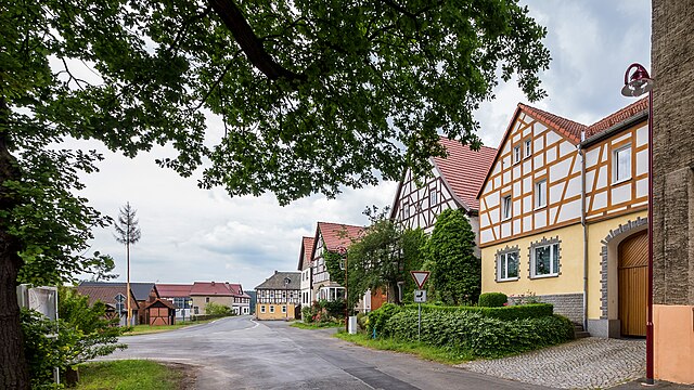
Ranis and Ziegenrück, located in the Thuringia region of Germany, are beautiful areas that offer a variety of hiking opportunities. The landscape is characterized by rolling hills, dense forests, and scenic views, making it an excellent destination for outdoor enthusiasts.
Hiking Trails:
-
Thuringian Forest: This area is known for its extensive network of trails. You can find well-marked paths that cater to different skill levels, from easy walks to more challenging hikes.
-
Local Trails: The region features numerous local trails that take you through picturesque villages, alongside rivers, and past historical landmarks. Look for routes that lead to lookout points for stunning vistas of the surrounding countryside.
-
Nature Reserves: Explore nearby nature reserves that showcase the area's diverse flora and fauna. These reserves often have designated trails and offer a chance to connect with nature more intimately.
Trail Features:
- Well-Marked Paths: Most trails are well signposted, making navigation easier for both experienced and novice hikers.
- Scenic Views: Expect beautiful scenery, from lush forests to rocky terrain and flowing rivers.
- Cultural Highlights: Keep an eye out for local cultural and historical sites, including castles, churches, and monuments that reflect the region's rich history.
Hiking Tips:
- Seasonal Considerations: Always check the weather before heading out. The best seasons for hiking in this region are generally spring through early autumn when the weather is milder.
- Gear Up: Make sure to wear suitable hiking boots and bring adequate gear, including water, snacks, a map, and a first-aid kit.
- Respect Nature: Follow the Leave No Trace principles to preserve the natural beauty of the trails and surrounding areas.
Conclusion:
Hiking in Ranis and Ziegenrück provides an excellent way to experience the natural beauty and cultural heritage of Thuringia. Whether you’re looking for a leisurely stroll or a more vigorous trek, you’ll find plenty of options to explore and enjoy.
- Страна:

- Столица: Ранис
- Координаты: 50° 37' 0" N, 11° 38' 0" E


- GPS треки (wikiloc): [Ссылка]
- Википедия английская: wiki(en)
- Википедия национальная: wiki(de)
- Хранилище Wikidata: Wikidata: Q879883
- код Freebase: [/m/03cdjpr]
- код VIAF: Альт: [140479840]
- код GND: Альт: [10024964-4]
- код региона Германии: 160755013
Включает регионы:

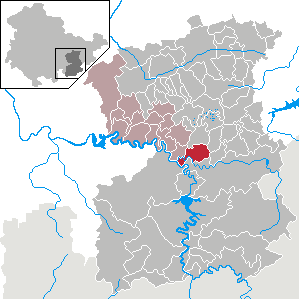
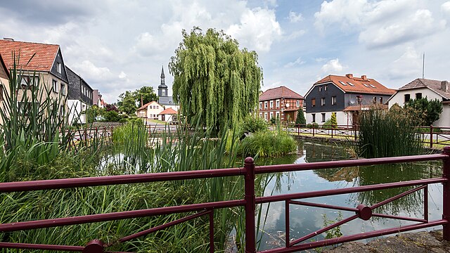
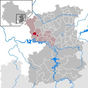
Цигенрюк
Hiking in Цигенрюк
Ziegenrück is a charming town located in the Thuringia region of Germany, nestled in the picturesque valley of the River Saale. The area offers a variety of hiking opportunities, perfect for both casual walkers and serious trekkers. Here are some highlights to consider if you plan to hike in Ziegenrück:...
- Страна:
- Почтовый код: 07924
- Телефонный код: 036483
- Код автомобильного номера: SOK
- Координаты: 50° 37' 0" N, 11° 39' 0" E
- GPS треки (wikiloc): [Ссылка]
- Высота над уровнем моря: 318 м m
- Площадь: 8.24 кв.км
- Население: 647
- Веб сайт: [Ссылка]

Шморда
Hiking in Шморда
Schmorda seems to be a lesser-known location, and there might not be extensive information specifically focused on it. If Schmorda is a small village or area, it's likely that the hiking opportunities would involve local trails that showcase the natural beauty of the region, possibly through forests, hills, or along rivers....
- Страна:
- Почтовый код: 07389
- Телефонный код: 03647
- Код автомобильного номера: SOK
- Координаты: 50° 38' 41" N, 11° 35' 10" E
- GPS треки (wikiloc): [Ссылка]
- Высота над уровнем моря: 510 м m
- Площадь: 4.84 кв.км
- Население: 83
- Веб сайт: [Ссылка]

Криспендорф
Hiking in Криспендорф
Crispendorf is a picturesque village located in the Thuringian Forest in Germany. It's a great destination for hikers due to its beautiful landscapes, rich flora and fauna, and well-marked trails. Here are some key points to consider when hiking in Crispendorf:...
- Страна:
- Почтовый код: 07924
- Телефонный код: 03663
- Код автомобильного номера: SOK
- Координаты: 50° 36' 0" N, 11° 44' 0" E
- GPS треки (wikiloc): [Ссылка]
- Высота над уровнем моря: 430 м m
- Площадь: 11.31 кв.км
- Население: 378
- Веб сайт: [Ссылка]


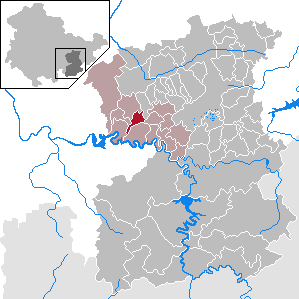
Ранис
Hiking in Ранис
Ranis is a beautiful and lesser-known destination in India that is increasingly gaining attention for its natural splendor and hiking opportunities. Here are some key points about hiking in the area:...
- Страна:
- Почтовый код: 07389
- Телефонный код: 03647
- Код автомобильного номера: LBS; SCZ; PN; SOK
- Координаты: 50° 39' 50" N, 11° 34' 5" E
- GPS треки (wikiloc): [Ссылка]
- Высота над уровнем моря: 380 м m
- Площадь: 10.55 кв.км
- Население: 1720
- Веб сайт: [Ссылка]


Вильхельмсдорф
Hiking in Вильхельмсдорф
Wilhelmsdorf, located in Thuringia, Germany, is a small village surrounded by beautiful natural landscapes ideal for hiking enthusiasts. The region is known for its rolling hills, dense forests, and scenic views, making it a great place for both leisurely walks and more challenging hikes....
- Страна:
- Почтовый код: 07389
- Телефонный код: 03647
- Код автомобильного номера: SOK
- Координаты: 50° 37' 48" N, 11° 33' 2" E
- GPS треки (wikiloc): [Ссылка]
- Высота над уровнем моря: 427 м m
- Площадь: 9.27 кв.км
- Население: 209
- Веб сайт: [Ссылка]

Гёссиц
Hiking in Гёссиц
Gössitz is a small region that may not be widely recognized among major hiking destinations, but if you’re looking for hiking opportunities in or around the area, it can offer some hidden gems for outdoor enthusiasts....
- Страна:
- Почтовый код: 07389
- Телефонный код: 036483
- Код автомобильного номера: SOK
- Координаты: 50° 37' 14" N, 11° 35' 14" E
- GPS треки (wikiloc): [Ссылка]
- Высота над уровнем моря: 480 м m
- Площадь: 12.86 кв.км
- Население: 304
- Веб сайт: [Ссылка]

Паска
Hiking in Паска
Paska, Germany is not specifically recognized as a well-known hiking destination, so it's possible you may be referring to a smaller village or a region nearby. However, Germany as a whole offers a wealth of hiking opportunities across various landscapes....
- Страна:
- Почтовый код: 07381
- Телефонный код: 036483
- Код автомобильного номера: SOK
- Координаты: 50° 37' 15" N, 11° 37' 44" E
- GPS треки (wikiloc): [Ссылка]
- Высота над уровнем моря: 440 м m
- Площадь: 6.59 кв.км
- Население: 107
- Веб сайт: [Ссылка]


Пойшен
Hiking in Пойшен
It seems there might be a small typo in your request. If you meant "Pérouges," or if you're referring to a specific area or region, please clarify that. However, if you are interested in hiking in a specific place or region in a country, I'd be happy to provide some general guidance on hiking in that area....
- Страна:
- Почтовый код: 07389
- Телефонный код: 03647
- Код автомобильного номера: SOK
- Координаты: 50° 39' 32" N, 11° 38' 37" E
- GPS треки (wikiloc): [Ссылка]
- Высота над уровнем моря: 470 м m
- Площадь: 7.53 кв.км
- Население: 454
- Веб сайт: [Ссылка]

Зайсла
Hiking in Зайсла
Seisla, also known as Siusi allo Sciliar, is a picturesque village located in the South Tyrol region of northern Italy, nestled at the foothills of the Sciliar massif in the Dolomites. This area is renowned for its stunning landscapes, rich biodiversity, and well-marked hiking trails, making it a great destination for hikers of all levels. Here are some key points to consider when hiking in Seisla:...
- Страна:
- Почтовый код: 07389
- Телефонный код: 03647
- Код автомобильного номера: SOK
- Координаты: 50° 39' 2" N, 11° 32' 5" E
- GPS треки (wikiloc): [Ссылка]
- Высота над уровнем моря: 350 м m
- Площадь: 4.84 кв.км
- Население: 144
- Веб сайт: [Ссылка]
Эсбах
Hiking in Эсбах
Eßbach is a small village located in Germany, known for its picturesque landscapes and proximity to natural areas that offer great hiking opportunities. While specific trails may vary, you can generally expect to find scenic routes that traverse beautiful forests, hills, and possibly streams, providing a peaceful hiking experience....
- Страна:
- Почтовый код: 07924
- Телефонный код: 036483
- Код автомобильного номера: SOK
- Координаты: 50° 35' 0" N, 11° 41' 0" E
- GPS треки (wikiloc): [Ссылка]
- Высота над уровнем моря: 433 м m
- Площадь: 5.28 кв.км
- Население: 234
- Веб сайт: [Ссылка]

Мокса
Hiking in Мокса
Moxa, also known as Moxa Mountain, is situated in the region of the Balkan Mountains in Bulgaria. This area offers stunning scenic views, diverse flora and fauna, and numerous trails for hikers of varying skill levels. Here are some key points about hiking in Moxa:...
- Страна:
- Почтовый код: 07381
- Телефонный код: 036483
- Код автомобильного номера: SOK
- Координаты: 50° 38' 28" N, 11° 37' 47" E
- GPS треки (wikiloc): [Ссылка]
- Высота над уровнем моря: 430 м m
- Площадь: 4.67 кв.км
- Население: 80
- Веб сайт: [Ссылка]
Шёндорф
Hiking in Шёндорф
Schöndorf is a picturesque village in the Thuringia region of Germany known for its stunning natural landscapes and numerous hiking opportunities. Nestled within the lush greenery of the Thuringian Forest, it serves as a great starting point for both casual walkers and dedicated hikers....
- Страна:
- Почтовый код: 07924
- Телефонный код: 036483
- Код автомобильного номера: SOK
- Координаты: 50° 37' 0" N, 11° 42' 0" E
- GPS треки (wikiloc): [Ссылка]
- Высота над уровнем моря: 440 м m
- Площадь: 10.11 кв.км
- Население: 274
- Веб сайт: [Ссылка]


Кайла
Hiking in Кайла
Keila is a charming small town in Germany that offers access to beautiful natural landscapes, ideal for hiking enthusiasts. Although Keila itself may not be as widely recognized as a major hiking destination, the surrounding areas provide several opportunities for outdoor activities....
- Страна:
- Почтовый код: 07389
- Телефонный код: 036483
- Код автомобильного номера: SOK
- Координаты: 50° 38' 16" N, 11° 39' 44" E
- GPS треки (wikiloc): [Ссылка]
- Высота над уровнем моря: 475 м m
- Площадь: 4.16 кв.км
- Население: 71
- Веб сайт: [Ссылка]