Ревест-де-Брус (Revest-des-Brousses, Revest-des-Brousses)
- коммуна во Франции
 Hiking in Ревест-де-Брус
Revest-des-Brousses is a charming commune located in the Alpes-de-Haute-Provence region of southeastern France. This area offers a variety of beautiful hiking opportunities, surrounded by stunning landscapes of hills, forests, and rural vistas.
Hiking Trails
-
Local Trails: The area has several marked trails catering to different skill levels. Whether you're a beginner or an experienced hiker, you can find routes that suit your preference. Trails often lead through picturesque scenery, offering views of the Verdon Gorge and local flora and fauna.
-
Natural Reserves: Being close to the Verdon Regional Natural Park, you can easily access additional trails that provide breathtaking views and a chance to encounter diverse wildlife.
-
Cultural Hikes: Some trails may include paths that pass by historical sites or traditional Provençal architecture, allowing hikers to explore the cultural heritage of the region while enjoying nature.
Best Times to Hike
Spring (April to June) and fall (September to November) are generally the best times to hike in Revest-des-Brousses. The weather is mild, and the landscape is vibrant, making for a pleasant hiking experience. Summer can be quite hot, so it's essential to plan hikes for early morning or late afternoon.
Preparation Tips
- Gear: Wear good hiking boots and carry a backpack with water, snacks, a map, and a first-aid kit.
- Weather: Check the weather before heading out as conditions can change rapidly in mountainous areas.
- Guided Tours: If you're unfamiliar with the area or prefer guided experiences, consider joining a local hiking group or hiring a guide.
Enjoying the Experience
Remember to take your time to appreciate the natural beauty and tranquility that Revest-des-Brousses has to offer. Whether you’re hiking with family, friends, or solo, the region’s serene environment can provide a refreshing escape from the hustle and bustle of everyday life.
- Страна:

- Почтовый код: 04150
- Координаты: 43° 58' 19" N, 5° 40' 18" E


- GPS треки (wikiloc): [Ссылка]
- Площадь: 22.95 кв.км
- Население: 271
- Википедия русская: wiki(ru)
- Википедия английская: wiki(en)
- Википедия национальная: wiki(fr)
- Хранилище Wikidata: Wikidata: Q1018585
- Катеория в википедии: [Ссылка]
- код Freebase: [/m/03m7x7p]
- код Freebase: [/m/03m7x7p]
- код GeoNames: Альт: [2983819]
- код GeoNames: Альт: [2983819]
- номер SIREN: [210401626]
- номер SIREN: [210401626]
- код муниципалитета INSEE: 04162
- код муниципалитета INSEE: 04162
Граничит с регионами:

Сен-Мишель-л’Обсерватуар
- коммуна во Франции
Hiking in Сен-Мишель-л’Обсерватуар
Saint-Michel-l'Observatoire, located in the Alpes-de-Haute-Provence region of France, offers a unique blend of natural beauty and cultural significance, making it a fantastic destination for hiking enthusiasts. Here are some highlights and tips for hiking in this area:...
- Страна:
- Почтовый код: 04870
- Координаты: 43° 54' 35" N, 5° 42' 58" E
- GPS треки (wikiloc): [Ссылка]
- Площадь: 27.78 кв.км
- Население: 1240

Онгль
- коммуна во Франции
Hiking in Онгль
Ongles, located in the Alpes-de-Haute-Provence region of France, offers a unique hiking experience characterized by stunning landscapes, charming rustic villages, and a rich natural environment. Whether you're an experienced hiker or a beginner, you'll find various trails that cater to different skill levels....
- Страна:
- Почтовый код: 04230
- Координаты: 44° 1' 40" N, 5° 44' 1" E
- GPS треки (wikiloc): [Ссылка]
- Площадь: 31.46 кв.км
- Население: 363
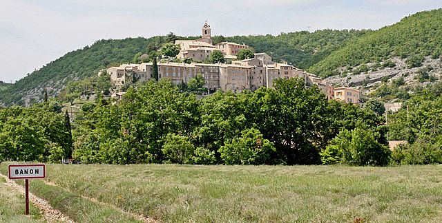
Банон
- коммуна во Франции
Hiking in Банон
Banon, situated in the Alpes-de-Haute-Provence region of France, is a charming village known for its picturesque landscapes, rich history, and excellent hiking opportunities. Here's a guide to hiking in and around Banon:...
- Страна:
- Почтовый код: 04150
- Координаты: 44° 2' 17" N, 5° 37' 41" E
- GPS треки (wikiloc): [Ссылка]
- Площадь: 39.81 кв.км
- Население: 966
- Веб сайт: [Ссылка]

Лиман
- коммуна во Франции
Hiking in Лиман
Hiking in Limans, or coastal areas and wetlands, can be a unique and rewarding experience. However, it seems you might be referring to a specific region, as "Limans" could pertain to various geographical features depending on the context. Here are a few general tips and highlights for hiking in coastal or wetland regions that could be relevant:...
- Страна:
- Почтовый код: 04300
- Координаты: 43° 59' 6" N, 5° 43' 50" E
- GPS треки (wikiloc): [Ссылка]
- Площадь: 20.97 кв.км
- Население: 365

Ман
- коммуна во Франции
Hiking in Ман
Mane, located in the Alpes-de-Haute-Provence region of France, offers a picturesque setting for hiking enthusiasts. Nestled in the foothills of the Luberon mountains and surrounded by lush landscapes, it provides a variety of trails suitable for all levels of hikers....
- Страна:
- Почтовый код: 04300
- Координаты: 43° 56' 18" N, 5° 46' 3" E
- GPS треки (wikiloc): [Ссылка]
- Площадь: 22 кв.км
- Население: 1367
- Веб сайт: [Ссылка]

Обна-лез-Альп
- коммуна во Франции
Hiking in Обна-лез-Альп
Aubenas-les-Alpes is a charming village located in the Alpes-de-Haute-Provence region in southeastern France. It's surrounded by stunning landscapes that make it a great location for hiking enthusiasts. Here are some key points to consider if you're planning a hike in the area:...
- Страна:
- Почтовый код: 04110
- Координаты: 43° 55' 52" N, 5° 40' 50" E
- GPS треки (wikiloc): [Ссылка]
- Площадь: 7.93 кв.км
- Население: 103

Вашер
- коммуна во Франции
Hiking in Вашер
Vachères is a charming village located in the Provence-Alpes-Côte d'Azur region of southeastern France. Nestled in the heart of the Luberon area, it offers stunning natural landscapes, picturesque views, and a variety of hiking trails suited for all skill levels. Here are some highlights of hiking in Vachères:...
- Страна:
- Почтовый код: 04110
- Координаты: 43° 55' 53" N, 5° 38' 18" E
- GPS треки (wikiloc): [Ссылка]
- Площадь: 23.42 кв.км
- Население: 264