Рибейре (Ribeyret, Ribeyret)
- коммуна во Франции
 Hiking in Рибейре
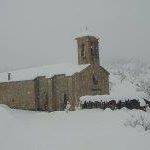
Ribeyret is a picturesque village located in the Hautes-Alpes department of the Provence-Alpes-Côte d'Azur region in southeastern France. The area around Ribeyret is known for its stunning landscapes, diverse flora and fauna, and great opportunities for hiking and outdoor activities.
Hiking Opportunities in Ribeyret:
-
Scenic Views: Hiking in Ribeyret offers breathtaking views of the surrounding mountains, valleys, and the unique geological formations that define the region. The Dauphiné Alps provide a stunning backdrop for many trails.
-
Trail Network: There are numerous well-marked hiking trails in and around Ribeyret, suitable for various skill levels. Whether you're a beginner or an experienced hiker, you'll find routes that cater to your abilities.
-
Wildlife Observation: The area is rich in biodiversity, and hikers may encounter various wildlife, including birds, butterflies, and other species native to the region. This makes it a great spot for nature enthusiasts.
-
Flora: The diverse ecosystems in the area host a wide range of plant species, including alpine flowers, coniferous forests, and expansive meadows. Spring and summer hikes can be especially rewarding with numerous blooms.
-
Cultural Experience: Hiking in Ribeyret also offers a chance to explore the local culture. You may find small villages, charming farmhouses, and traditional architecture as you walk through the region.
-
Accessibility: Most trails are accessible from the village, with varying degrees of difficulty and lengths. It's advisable to consult local maps or guides for the best routes.
Tips for Hiking in Ribeyret:
-
Check the Weather: The weather can change rapidly in the mountains, so make sure to check the forecast and dress in layers.
-
Stay Hydrated and Energized: Bring plenty of water and snacks to keep your energy up during the hike.
-
Trail Etiquette: Respect nature, stay on marked paths, and follow local guidelines to preserve the environment.
-
Safety First: Inform someone about your hiking plans and estimated return time, especially if you plan on tackling more remote trails.
-
Navigational Tools: Consider downloading maps or using a GPS device to help with navigating the trails, as some areas may have limited cell service.
With its natural beauty and rich culture, hiking in Ribeyret can offer a refreshing break and a chance to connect with the great outdoors. Enjoy your adventure!
- Страна:

- Почтовый код: 05150
- Координаты: 44° 24' 48" N, 5° 33' 17" E


- GPS треки (wikiloc): [Ссылка]
- Площадь: 17.87 кв.км
- Население: 105
- Википедия русская: wiki(ru)
- Википедия английская: wiki(en)
- Википедия национальная: wiki(fr)
- Хранилище Wikidata: Wikidata: Q1085948
- Катеория в википедии: [Ссылка]
- код Freebase: [/m/03mfpgp]
- код Freebase: [/m/03mfpgp]
- код GeoNames: Альт: [6425619]
- код GeoNames: Альт: [6425619]
- номер SIREN: [210501177]
- номер SIREN: [210501177]
- код муниципалитета INSEE: 05117
- код муниципалитета INSEE: 05117
Граничит с регионами:
Сорбье
Hiking in Сорбье
Hiking in Sorbiers, located in the Hautes-Alpes region of France, offers a delightful experience for outdoor enthusiasts. This area is characterized by its stunning alpine scenery, diverse ecosystems, and a variety of trails suitable for hikers of all levels....
- Страна:
- Почтовый код: 05150
- Координаты: 44° 22' 29" N, 5° 33' 47" E
- GPS треки (wikiloc): [Ссылка]
- Площадь: 13.93 кв.км
- Население: 38

Сент-Андре-де-Розан
- коммуна во Франции
Hiking in Сент-Андре-де-Розан
Saint-André-de-Rosans is a charming village located in the Hautes-Alpes region of southeastern France. It's a fantastic area for hikers, offering a variety of trails that cater to different skill levels and preferences. Here are some highlights about hiking in this picturesque location:...
- Страна:
- Почтовый код: 05150
- Координаты: 44° 22' 38" N, 5° 30' 52" E
- GPS треки (wikiloc): [Ссылка]
- Площадь: 36.61 кв.км
- Население: 145
Монморен
Hiking in Монморен
Montmorin, located in the Hautes-Alpes region of France, is a stunning area for outdoor enthusiasts, particularly hikers. The region offers a variety of trails suitable for all skill levels, ranging from easy walks to more challenging hikes that reward adventurers with breathtaking views of the mountains and surrounding landscapes....
- Страна:
- Почтовый код: 05150
- Координаты: 44° 27' 5" N, 5° 32' 32" E
- GPS треки (wikiloc): [Ссылка]
- Площадь: 25.86 кв.км
- Население: 90

Муадан
- коммуна во Франции
Hiking in Муадан
Moydans is not a widely recognized hiking destination, and it seems there might be a spelling error or it might refer to a specific, lesser-known location or a local site unfamiliar to broader audiences. If you meant a different location or if it's a local spot, let me know!...
- Страна:
- Почтовый код: 05150
- Координаты: 44° 23' 59" N, 5° 30' 13" E
- GPS треки (wikiloc): [Ссылка]
- Высота над уровнем моря: 633 м m
- Площадь: 10.51 кв.км
- Население: 47


Л’Эпин
- коммуна во Франции
Hiking in Л’Эпин
L'Épine, located in the Hautes-Alpes region of southeastern France, is known for its stunning natural beauty and a variety of hiking trails that cater to different skill levels. The area is characterized by picturesque landscapes, mountain ranges, valleys, and lakes. Here are some key points about hiking in L'Épine and its surroundings:...
- Страна:
- Почтовый код: 05700
- Координаты: 44° 25' 1" N, 5° 37' 1" E
- GPS треки (wikiloc): [Ссылка]
- Площадь: 33.47 кв.км
- Население: 192