Рибьер (Ribiers, Ribiers)
- коммуна во Франции
 Hiking in Рибьер
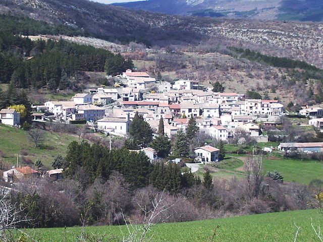
Ribiers is a charming village located in the Hautes-Alpes department of southeastern France. It is situated near the beautiful mountains of the French Alps, making it an appealing destination for hikers of all levels. Here are some key points to consider if you're planning a hiking trip in and around Ribiers:
1.
- The area offers a variety of hiking trails that range from easy walks to more challenging treks. You can enjoy stunning views of the surrounding mountains, valleys, and forests.
- Popular hikes include paths that lead to panoramic viewpoints and those that wind through the local flora and fauna.
2.
- The region around Ribiers is rich in biodiversity. Hikers may encounter various species of plants and animals. The vibrant landscapes change with the seasons, offering different experiences year-round.
3.
- While hiking, you may come across traditional Alpine architecture, churches, and historical sites that add cultural significance to your hike. Exploring these can enhance your outdoor adventure.
4.
- Ribiers is accessible from major towns in the region, and the starting points for many trails are within walking distance or a short drive from the village. There are also accommodations available for those who wish to stay longer.
5.
- Always check the local weather conditions before heading out, as mountain weather can change rapidly.
- Ensure you have suitable hiking gear, including sturdy footwear, plenty of water, and snacks.
- It might be helpful to bring a map or a GPS device, as some trails can be less marked.
6.
- If you're new to hiking or the area, consider joining a guided hike. Local guides can offer insights into the best routes, safety tips, and environmental knowledge.
7.
- Always follow the Leave No Trace principles to help preserve the natural beauty of the area. Stay on marked trails, pack out what you bring in, and respect wildlife.
Conclusion
Ribiers, with its stunning natural landscape and rich cultural tapestry, offers an excellent opportunity for hiking enthusiasts. Whether you’re a beginner or an experienced hiker, the trails around Ribiers provide a memorable outdoor experience.
- Страна:

- Почтовый код: 05300
- Координаты: 44° 13' 52" N, 5° 51' 23" E


- GPS треки (wikiloc): [Ссылка]
- Высота над уровнем моря: 972 м m
- Площадь: 36.55 кв.км
- Население: 817
- Веб сайт: http://www.mairie-ribiers.fr
- Википедия русская: wiki(ru)
- Википедия английская: wiki(en)
- Википедия национальная: wiki(fr)
- Хранилище Wikidata: Wikidata: Q1340843
- Катеория в википедии: [Ссылка]
- код Freebase: [/m/03mfpgb]
- код Freebase: [/m/03mfpgb]
- код GeoNames: Альт: [2983685]
- код GeoNames: Альт: [2983685]
- код BNF: [125616295]
- код BNF: [125616295]
- код муниципалитета INSEE: 05118
- код муниципалитета INSEE: 05118
Граничит с регионами:
Антонав
- коммуна во Франции
Hiking in Антонав
Antonaves is a small commune located in southeastern France, in the region of Auvergne-Rhône-Alpes. While it may not be as well-known as some larger hiking destinations, it offers access to beautiful natural landscapes typical of the French countryside....
- Страна:
- Почтовый код: 05300
- Координаты: 44° 15' 59" N, 5° 48' 17" E
- GPS треки (wikiloc): [Ссылка]
- Площадь: 8.03 кв.км
- Население: 170

Эурр
- коммуна во Франции
Hiking in Эурр
Éourres is a charming village located in the Hautes-Alpes region of France, near the stunning Dévoluy mountain range. It’s an ideal destination for hiking enthusiasts, offering various trails that cater to different skill levels and showcase the area’s natural beauty....
- Страна:
- Почтовый код: 26560
- Координаты: 44° 12' 44" N, 5° 41' 57" E
- GPS треки (wikiloc): [Ссылка]
- Площадь: 26.47 кв.км
- Население: 128
- Веб сайт: [Ссылка]

Систерон
- коммуна во Франции
Hiking in Систерон
Sisteron, located in southeastern France, is a beautiful destination for hiking enthusiasts, offering a mix of majestic landscapes, historical sites, and diverse trails suitable for various skill levels. Nestled between the Alps and the Provençal landscape, the region is characterized by its stunning cliffs, gorges, and the renowned Durance River....
- Страна:
- Почтовый код: 04200
- Координаты: 44° 11' 24" N, 5° 56' 47" E
- GPS треки (wikiloc): [Ссылка]
- Высота над уровнем моря: 485 м m
- Площадь: 50.25 кв.км
- Население: 7213
- Веб сайт: [Ссылка]

Бевон
- коммуна во Франции
Hiking in Бевон
Bevons is a beautiful area for hiking, known for its stunning natural landscapes, diverse trails, and captivating views. Here are some key highlights you might find useful if you're planning to hike in Bevons:...
- Страна:
- Почтовый код: 04200
- Координаты: 44° 10' 21" N, 5° 53' 26" E
- GPS треки (wikiloc): [Ссылка]
- Площадь: 11.26 кв.км
- Население: 238

Мизон
- коммуна во Франции
Hiking in Мизон
Mison, located in South Korea, is known for its beautiful landscapes and hiking opportunities, particularly in the vicinity of the Jiri Mountain range. While it may not be as widely recognized as some of the more famous hiking destinations in South Korea, it offers a unique experience for those looking to explore less crowded trails....
- Страна:
- Почтовый код: 04200
- Координаты: 44° 16' 3" N, 5° 51' 33" E
- GPS треки (wikiloc): [Ссылка]
- Площадь: 31.72 кв.км
- Население: 1106
- Веб сайт: [Ссылка]


Сен-Пьер-Аве
- коммуна во Франции
Hiking in Сен-Пьер-Аве
Saint-Pierre-Avez is a charming village in the Auvergne region of France, nestled in the heart of nature and surrounded by stunning landscapes. Hiking in this area offers a unique experience for outdoor enthusiasts, with various trails that cater to different skill levels....
- Страна:
- Почтовый код: 05300
- Координаты: 44° 15' 26" N, 5° 45' 40" E
- GPS треки (wikiloc): [Ссылка]
- Площадь: 11.37 кв.км
- Население: 30

Нуайе-сюр-Жаброн
- коммуна во Франции
Hiking in Нуайе-сюр-Жаброн
Noyers-sur-Jabron is a charming village located in the Provence-Alpes-Côte d'Azur region of southeastern France, known for its picturesque landscapes, historical architecture, and natural beauty. Hiking in this area offers a variety of trails that cater to different skill levels, making it a great destination for both novice and experienced hikers....
- Страна:
- Почтовый код: 04200
- Координаты: 44° 10' 8" N, 5° 49' 41" E
- GPS треки (wikiloc): [Ссылка]
- Площадь: 56.58 кв.км
- Население: 510