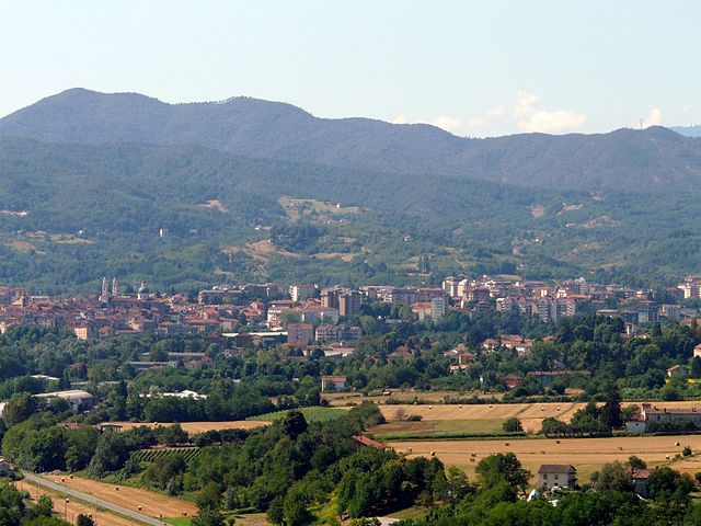
Рокка-Гримальда (Rocca Grimalda, Rocca Grimalda)
- коммуна в регионе Пьемонт, Италия
 Hiking in Рокка-Гримальда
Rocca Grimalda is a picturesque village located in the Piedmont region of Italy, known for its stunning landscapes and historical significance. Hiking in this area offers a blend of scenic views, cultural heritage, and a chance to explore the natural environment.
Trails and Routes
-
Natural Paths: There are several marked trails in and around Rocca Grimalda that cater to various skill levels. The trails often pass through lush woods, vineyards, and offer panoramic views of the surrounding hills and valleys.
-
Cultural Walks: Some routes incorporate visits to historical sites such as ancient churches, castles, and traditional villages. Exploring the cultural heritage of the area can enrich your hiking experience.
-
Lake of Rocca Grimalda: Nearby, there are serene lakes where you can combine hiking with a leisurely stroll or a picnic by the water.
Best Hiking Practices
-
Preparation: Check the weather forecast before heading out, as conditions can change quickly in mountainous areas. Make sure to bring water, snacks, and essentials like a map or GPS.
-
Footwear: Wear sturdy, comfortable hiking shoes suitable for uneven terrain.
-
Respect Nature: Stay on marked paths to protect the local flora and fauna. Carry out what you take in and leave no trace.
Local Flora and Fauna
The region is rich in biodiversity, with various species of plants and animals. Be on the lookout for local wildlife, and take time to appreciate the natural surroundings.
Additional Tips
-
Guided Tours: Consider joining a guided hiking tour for a more in-depth experience that includes local knowledge and insights about the area's history and ecology.
-
Seasonal Hiking: Spring and fall are particularly beautiful times to hike in this area, with mild temperatures and vibrant foliage.
Overall, hiking in Rocca Grimalda provides a unique blend of natural beauty and cultural exploration, making it a rewarding destination for outdoor enthusiasts. Enjoy your hike!
- Страна:

- Почтовый код: 15078
- Телефонный код: 0143
- Код автомобильного номера: AL
- Координаты: 44° 40' 21" N, 8° 38' 58" E


- GPS треки (wikiloc): [Ссылка]
- Высота над уровнем моря: 280 м m
- Площадь: 15.46 кв.км
- Население: 1503
- Веб сайт: http://www.comuneroccagrimalda.it
- Википедия русская: wiki(ru)
- Википедия английская: wiki(en)
- Википедия национальная: wiki(it)
- Хранилище Wikidata: Wikidata: Q17654
- Галерея изображений в википедии: [Ссылка]
- Катеория в википедии: [Ссылка]
- код Freebase: [/m/0f8_4m]
- код GeoNames: Альт: [6543044]
- код VIAF: Альт: [131547198]
- ID отношения в OpenStreetMap: [43443]
- UN/LOCODE: [ITRGI]
- код ISTAT: 006147
- кадастровый код Италии: H414
Граничит с регионами:

Каприата-д'Орба
- коммуна в регионе Пьемонт, Италия
Hiking in Каприата-д'Орба
Capriata d'Orba is a charming destination in the Piedmont region of Italy, known for its beautiful landscapes and outdoor activities, including hiking. Nestled in the hills, it offers a variety of trails that showcase the stunning natural beauty and cultural heritage of the area....
- Страна:
- Почтовый код: 15060
- Телефонный код: 0143
- Код автомобильного номера: AL
- Координаты: 44° 43' 44" N, 8° 41' 25" E
- GPS треки (wikiloc): [Ссылка]
- Высота над уровнем моря: 176 м m
- Площадь: 28.47 кв.км
- Население: 1858
- Веб сайт: [Ссылка]
Карпенето
- коммуна в регионе Пьемонт, Италия
Hiking in Карпенето
Carpeneto is a picturesque commune located in the Piedmont region of northwest Italy, nestled within the Apennine Mountains. The area offers a range of hiking opportunities for both beginners and more experienced hikers, combining natural beauty with cultural heritage....
- Страна:
- Почтовый код: 15071
- Телефонный код: 0143
- Код автомобильного номера: AL
- Координаты: 44° 40' 42" N, 8° 36' 20" E
- GPS треки (wikiloc): [Ссылка]
- Высота над уровнем моря: 329 м m
- Площадь: 13.34 кв.км
- Население: 977
- Веб сайт: [Ссылка]

Овада
- коммуна в регионе Пьемонт, Италия
Hiking in Овада
Ovada is a charming town located in the Piedmont region of northwest Italy, surrounded by beautiful landscapes that offer excellent hiking opportunities. The area is characterized by rolling hills, vineyards, and lush greenery, making it an ideal destination for both novice and experienced hikers. Here are some key points to consider when hiking in and around Ovada:...
- Страна:
- Почтовый код: 15076
- Телефонный код: 0143
- Код автомобильного номера: AL
- Координаты: 44° 38' 21" N, 8° 38' 47" E
- GPS треки (wikiloc): [Ссылка]
- Высота над уровнем моря: 186 м m
- Площадь: 35.37 кв.км
- Население: 11365
- Веб сайт: [Ссылка]

Предоза
- коммуна в регионе Пьемонт, Италия
Hiking in Предоза
Predosa is a charming municipality located in the province of Alessandria, in the Piedmont region of northwestern Italy. While not as widely known as some other hiking destinations in the region, it still offers beautiful landscapes and an opportunity to experience the natural beauty of the area....
- Страна:
- Почтовый код: 15077
- Телефонный код: 0131
- Код автомобильного номера: AL
- Координаты: 44° 45' 8" N, 8° 39' 23" E
- GPS треки (wikiloc): [Ссылка]
- Высота над уровнем моря: 136 м m
- Площадь: 33.01 кв.км
- Население: 2010
- Веб сайт: [Ссылка]

Сильвано-д'Орба
- коммуна в регионе Пьемонт, Италия
Hiking in Сильвано-д'Орба
Silvano d'Orba is a charming village located in the Piedmont region of Italy, nestled in the hills between the Po River and the Ligurian Apennines. This area offers a variety of hiking opportunities, showcasing beautiful landscapes, lush nature, and a glimpse into rural Italian life....
- Страна:
- Почтовый код: 15060
- Телефонный код: 0143
- Код автомобильного номера: AL
- Координаты: 44° 41' 16" N, 8° 40' 36" E
- GPS треки (wikiloc): [Ссылка]
- Высота над уровнем моря: 175 м m
- Площадь: 12.17 кв.км
- Население: 1980
- Веб сайт: [Ссылка]

Тризоббио
- коммуна в регионе Пьемонт, Италия
Hiking in Тризоббио
Trisobbio, located in the region of Liguria, Italy, is known for its picturesque landscapes and hiking opportunities. The area is characterized by rolling hills, vineyards, and stunning views of the surrounding countryside. Here are some key points to consider for hiking in Trisobbio:...
- Страна:
- Почтовый код: 15070
- Телефонный код: 0143
- Код автомобильного номера: AL
- Координаты: 44° 39' 45" N, 8° 35' 14" E
- GPS треки (wikiloc): [Ссылка]
- Высота над уровнем моря: 341 м m
- Площадь: 9 кв.км
- Население: 677
- Веб сайт: [Ссылка]