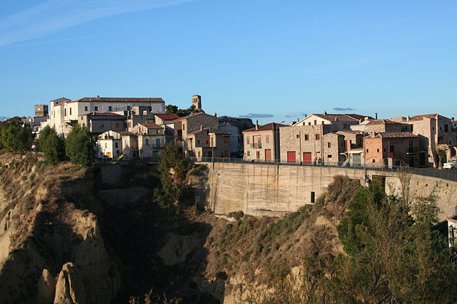
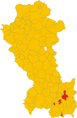
Рокканова (Roccanova, Roccanova)
.svg)
- коммуна Италии
 Hiking in Рокканова
Roccanova is a charming destination located in the Basilicata region of southern Italy. Nestled in the Apennine Mountains, it offers a range of hiking opportunities for outdoor enthusiasts. Here’s a guide to help you explore the hiking options in and around Roccanova:
Trails and Routes
-
Local Nature Trails: Roccanova and its surrounding areas have several marked trails that cater to various skill levels. The trails often meander through lush forests, rocky terrain, and scenic viewpoints.
-
Parco Nazionale del Pollino: While not directly in Roccanova, this national park is nearby and offers some of the best hiking in the region. The park features a diverse landscape with dramatic mountains, deep gorges, and rich biodiversity. Popular hikes include the routes to the Serra Dolcedorme and the Timpa di Montalto.
-
Historical Paths: Some trails in the area may also take you past historical landmarks, such as ancient villages or ruins, allowing hikers to experience the cultural heritage of Basilicata.
Difficulty Levels
- Easy Trails: Suitable for families or beginners, often with gentle slopes and well-marked paths.
- Moderate Trails: These may include some elevation gain and can take several hours to complete. A good choice for those with some hiking experience.
- Challenging Trails: For experienced hikers, these routes can involve steep ascents, rocky paths, and variable weather conditions.
Best Times to Go
- Spring (April to June): Ideal for hiking, with pleasant temperatures and blooming wildflowers.
- Fall (September to November): Offers beautiful autumn foliage and cooler temperatures, perfect for traversing the trails.
- Summer (July to August): It can be quite hot, so early morning or late afternoon hikes are recommended.
Tips for Hiking in Roccanova
- Gear Up: Make sure to wear sturdy hiking boots, comfortable clothing, and carry a daypack with water, snacks, a first-aid kit, and a map or GPS device.
- Stay Hydrated: Bring enough water, as natural water sources may not be available on all trails.
- Local Guides: Consider hiring a local guide for a more informative experience, especially if you want to explore hidden gems off the beaten path.
- Respect Nature: Follow Leave No Trace principles to preserve the natural beauty of the area.
Wildlife and Flora
Hiking in Roccanova offers opportunities to observe local wildlife, including various bird species and possibly deer. The region is rich in flora, with different types of trees, wildflowers, and herbs that are native to the Italian landscape.
Whether you're looking for a peaceful walk in nature or an adventurous climb, Roccanova has something to offer every hiking enthusiast. Enjoy your journey!
- Страна:

- Почтовый код: 85036
- Телефонный код: 0973
- Код автомобильного номера: PZ
- Координаты: 40° 13' 0" N, 16° 12' 0" E


- GPS треки (wikiloc): [Ссылка]
- Высота над уровнем моря: 648 м m
- Площадь: 61.74 кв.км
- Население: 1477
- Веб сайт: http://www.comune.roccanova.pz.it/
- Википедия русская: wiki(ru)
- Википедия английская: wiki(en)
- Википедия национальная: wiki(it)
- Хранилище Wikidata: Wikidata: Q52649
- Катеория в википедии: [Ссылка]
Граничит с регионами:

Алиано
- коммуна Италии
Hiking in Алиано
Aliano is a small village located in the Basilicata region of southern Italy. It is known for its stunning landscapes, rugged terrain, and rich cultural heritage. While primarily recognized for its historical significance and as a filming location for the Italian movie "Christ Stopped at Eboli," Aliano and its surrounding areas offer beautiful hiking opportunities for outdoor enthusiasts....
- Страна:
- Почтовый код: 75010
- Телефонный код: 0835
- Код автомобильного номера: MT
- Координаты: 40° 19' 0" N, 16° 14' 0" E
- GPS треки (wikiloc): [Ссылка]
- Высота над уровнем моря: 498 м m
- Площадь: 98.41 кв.км
- Население: 967
- Веб сайт: [Ссылка]
Кастронуово-ди-Сант'Андреа
- коммуна Италии
Hiking in Кастронуово-ди-Сант'Андреа
Castronuovo di Sant'Andrea is a small village located in the Basilicata region of southern Italy, surrounded by the picturesque Apennine Mountains. This area offers some beautiful hiking opportunities, with trails that showcase the natural beauty and rugged landscapes of the region....
- Страна:
- Почтовый код: 85030
- Телефонный код: 0973
- Код автомобильного номера: PZ
- Координаты: 40° 11' 0" N, 16° 11' 0" E
- GPS треки (wikiloc): [Ссылка]
- Высота над уровнем моря: 650 м m
- Площадь: 47.45 кв.км
- Население: 1016
- Веб сайт: [Ссылка]

Кьяромонте
- коммуна Италии
Hiking in Кьяромонте
Chiaromonte is a charming hilltop town located in the Basilicata region of southern Italy, and it offers some fantastic opportunities for hiking. Here are some key points about hiking in and around Chiaromonte:...
- Страна:
- Почтовый код: 85032
- Телефонный код: 0973
- Код автомобильного номера: PZ
- Координаты: 40° 7' 0" N, 16° 13' 0" E
- GPS треки (wikiloc): [Ссылка]
- Высота над уровнем моря: 794 м m
- Площадь: 70.02 кв.км
- Население: 1922
- Веб сайт: [Ссылка]

Галликкьо
- коммуна Италии
Hiking in Галликкьо
Gallicchio is a charming village located in the Basilicata region of southern Italy, surrounded by the stunning landscapes characteristic of this area. Hiking in Gallicchio can offer a wonderful blend of natural beauty, historical exploration, and cultural experiences....
- Страна:
- Почтовый код: 85010
- Телефонный код: 0971
- Код автомобильного номера: PZ
- Координаты: 40° 17' 0" N, 16° 8' 0" E
- GPS треки (wikiloc): [Ссылка]
- Высота над уровнем моря: 730 м m
- Площадь: 23.63 кв.км
- Население: 888
- Веб сайт: [Ссылка]
Миссанелло
- коммуна Италии
Hiking in Миссанелло
Missanello, located in the beautiful region of Basilicata, Italy, offers a variety of hiking opportunities for both novice and experienced hikers. The area is characterized by its stunning natural landscapes, which include rolling hills, lush forests, and scenic views of the surrounding mountains....
- Страна:
- Почтовый код: 85010
- Телефонный код: 0971
- Код автомобильного номера: PZ
- Координаты: 40° 17' 0" N, 16° 10' 0" E
- GPS треки (wikiloc): [Ссылка]
- Высота над уровнем моря: 604 м m
- Площадь: 22.34 кв.км
- Население: 564
- Веб сайт: [Ссылка]
Сан-Кирико-Рапаро
- коммуна Италии
Hiking in Сан-Кирико-Рапаро
San Chirico Raparo is a small town located in the Basilicata region of southern Italy. Nestled in the Apennine mountain range, it offers a unique blend of scenic beauty, cultural heritage, and opportunities for hiking enthusiasts. Here’s what you need to know about hiking in and around San Chirico Raparo:...
- Страна:
- Почтовый код: 85030
- Телефонный код: 0973
- Код автомобильного номера: PZ
- Координаты: 40° 11' 0" N, 16° 5' 0" E
- GPS треки (wikiloc): [Ссылка]
- Высота над уровнем моря: 780 м m
- Площадь: 84.07 кв.км
- Население: 1032
- Веб сайт: [Ссылка]
Сант'Арканджело
- коммуна Италии
Hiking in Сант'Арканджело
Sant'Arcangelo, located in the Basilicata region of Italy, is known for its beautiful landscapes, rich history, and charming architecture. Hiking in this area can be a rewarding experience, offering stunning views and opportunities to explore the natural and cultural heritage of the region....
- Страна:
- Почтовый код: 85037
- Телефонный код: 0973
- Код автомобильного номера: PZ
- Координаты: 40° 14' 55" N, 16° 16' 14" E
- GPS треки (wikiloc): [Ссылка]
- Высота над уровнем моря: 388 м m
- Площадь: 89.1 кв.км
- Население: 6448
- Веб сайт: [Ссылка]
Сенизе
- коммуна Италии
Hiking in Сенизе
Senise, a charming town located in the Basilicata region of Italy, offers an array of hiking opportunities in a stunning natural environment. The surrounding area is characterized by rolling hills, lush forests, and breathtaking views. Here are some highlights and suggestions for hiking in Senise:...
- Страна:
- Почтовый код: 85038
- Телефонный код: 0973
- Код автомобильного номера: PZ
- Координаты: 40° 8' 0" N, 16° 17' 0" E
- GPS треки (wikiloc): [Ссылка]
- Высота над уровнем моря: 335 м m
- Площадь: 97.31 кв.км
- Население: 6995
- Веб сайт: [Ссылка]