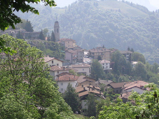
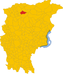
Ронкобелло (Roncobello, Roncobello)
.svg)
- коммуна Италии
 Hiking in Ронкобелло
Roncobello is a charming village located in the Bergamasque Alps in northern Italy. It’s a fantastic destination for hiking enthusiasts, offering a range of trails that cater to different skill levels and preferences. Here are some highlights:
Scenic Trails
-
Roncobello to Pizzo dei Tre Signori: This is a popular hike that takes you to one of the highest peaks in the area. The trail offers stunning views of the surrounding mountains and valleys. The ascent can be challenging, so it's suitable for experienced hikers.
-
Sentiero dei Fiori (Path of Flowers): This trail is ideal for families and those looking for a leisurely hike. It winds through meadows rich in flora, especially beautiful during the spring and summer months.
-
Valle di Grumello: A less strenuous option, this valley offers picturesque landscapes, and the trail is generally well-marked. It’s an excellent choice for a peaceful day hike.
Nature and Wildlife
The area around Roncobello is rich in biodiversity. As you hike, you might encounter various wildlife species and enjoy the diverse vegetation, particularly in the protected natural parks nearby.
Best Time to Visit
The best months for hiking in Roncobello are typically from late spring through early autumn (May to September). During this period, the weather is generally mild, and the trails are fully accessible.
Preparation
- Gear: Proper hiking boots, weather-appropriate clothing, and a good backpack are recommended. Always carry enough water and snacks.
- Maps and Guides: It’s wise to have a trail map or a GPS device to navigate the trails. Local tourist offices often provide maps and can offer advice on current trail conditions.
Safety Considerations
- Always inform someone about your hiking plans and expected return time.
- Check the weather forecast before heading out, as mountain weather can change rapidly.
- If you're unsure about a trail's difficulty, consult with local hikers or guides for advice.
Conclusion
Roncobello is an excellent destination for hikers seeking beautiful mountain scenery and varied trail options. Whether you’re looking for a challenging ascent or a leisurely nature walk, the region offers something for everyone. Enjoy your adventure in the stunning Bergamasque Alps!
- Страна:

- Почтовый код: 24010
- Телефонный код: 0345
- Код автомобильного номера: BG
- Координаты: 45° 57' 0" N, 9° 45' 0" E


- GPS треки (wikiloc): [Ссылка]
- Высота над уровнем моря: 1007 м m
- Площадь: 25.39 кв.км
- Население: 433
- Веб сайт: http://www.comune.roncobello.bg.it
- Википедия русская: wiki(ru)
- Википедия английская: wiki(en)
- Википедия национальная: wiki(it)
- Хранилище Wikidata: Wikidata: Q101515
- Галерея изображений в википедии: [Ссылка]
- Катеория в википедии: [Ссылка]
- код Freebase: [/m/0gjddm]
- код GeoNames: Альт: [6543165]
- код VIAF: Альт: [127124734]
- ID отношения в OpenStreetMap: [46541]
- код ISTAT: 016184
- кадастровый код Италии: H535
Граничит с регионами:

Доссена
- коммуна Италии
Hiking in Доссена
Dossena is a charming municipality located in the province of Bergamo, Lombardy, Italy. It's nestled in the foothills of the Alps and offers a variety of hiking opportunities, showcasing beautiful landscapes, lush forests, and historical sites....
- Страна:
- Почтовый код: 24010
- Телефонный код: 0345
- Код автомобильного номера: BG
- Координаты: 45° 53' 0" N, 9° 42' 0" E
- GPS треки (wikiloc): [Ссылка]
- Высота над уровнем моря: 986 м m
- Площадь: 19.56 кв.км
- Население: 919
- Веб сайт: [Ссылка]

Изола-ди-Фондра
- коммуна Италии
Hiking in Изола-ди-Фондра
Isola di Fondra is a picturesque village in the province of Bergamo, located in the Lombardy region of northern Italy. Nestled in the heart of the Alps, it offers stunning landscapes, lush forests, and beautiful trails for hiking enthusiasts. Here are some key points to consider when hiking in Isola di Fondra:...
- Страна:
- Почтовый код: 24010
- Телефонный код: 0345
- Код автомобильного номера: BG
- Координаты: 45° 59' 0" N, 9° 45' 0" E
- GPS треки (wikiloc): [Ссылка]
- Высота над уровнем моря: 799 м m
- Площадь: 12.83 кв.км
- Население: 174
- Веб сайт: [Ссылка]


Ленна
- коммуна Италии
Hiking in Ленна
Lenna is a quaint village located in the Bergamo province of Lombardy, Italy. It is situated in a picturesque part of the Italian Alps, making it a great base for hiking enthusiasts. The area is characterized by stunning landscapes, rich flora and fauna, and a variety of trails that cater to different skill levels....
- Страна:
- Почтовый код: 24010
- Телефонный код: 0345
- Код автомобильного номера: BG
- Координаты: 45° 56' 36" N, 9° 40' 39" E
- GPS треки (wikiloc): [Ссылка]
- Высота над уровнем моря: 465 м m
- Площадь: 12.74 кв.км
- Население: 592
- Веб сайт: [Ссылка]


Мойо-де'-Кальви
- коммуна Италии
Hiking in Мойо-де'-Кальви
Moio de' Calvi is a charming village located in the province of Bergamo, Italy, in the Lombardy region. Nestled in the foothills of the Alps, it offers a picturesque setting for hiking enthusiasts. While the village itself is small and not overly commercialized, it serves as a gateway to some beautiful hiking routes in the surrounding area....
- Страна:
- Почтовый код: 24070
- Телефонный код: 0345
- Код автомобильного номера: BG
- Координаты: 45° 57' 6" N, 9° 42' 3" E
- GPS треки (wikiloc): [Ссылка]
- Высота над уровнем моря: 654 м m
- Площадь: 6.36 кв.км
- Население: 206
- Веб сайт: [Ссылка]


Ольтре-иль-Колле
- коммуна Италии
Hiking in Ольтре-иль-Колле
Oltre il Colle is a beautiful destination for hiking enthusiasts, located in the Seriana Valley in Italy, close to Bergamo. Known for its stunning landscapes, the area offers a range of trails suitable for various skill levels, from leisurely walks to more challenging hikes....
- Страна:
- Почтовый код: 24013
- Телефонный код: 0345
- Код автомобильного номера: BG
- Координаты: 45° 53' 0" N, 9° 46' 0" E
- GPS треки (wikiloc): [Ссылка]
- Высота над уровнем моря: 1030 м m
- Площадь: 32.89 кв.км
- Население: 1004
- Веб сайт: [Ссылка]


Серина
- коммуна Италии
Hiking in Серина
Serina, located in the Lombardy region of Italy, is a beautiful area for hiking enthusiasts. Nestled in the Seriana Valley, Serina offers stunning landscapes characterized by lush forests, rocky escarpments, and panoramic views of the surrounding mountains. Here are some key points to consider if you're planning a hiking trip to Serina:...
- Страна:
- Почтовый код: 24017
- Телефонный код: 0345
- Код автомобильного номера: BG
- Координаты: 45° 52' 0" N, 9° 44' 0" E
- GPS треки (wikiloc): [Ссылка]
- Высота над уровнем моря: 720 м m
- Площадь: 27.34 кв.км
- Население: 2077
- Веб сайт: [Ссылка]


Ардезьо
- коммуна Италии
Hiking in Ардезьо
Ardesio, located in the Seriana Valley in the Lombardy region of Italy, offers a variety of hiking opportunities for both beginners and experienced hikers. The area is characterized by its stunning landscapes, including lush forests, rocky terrains, and panoramic views of the surrounding mountains....
- Страна:
- Почтовый код: 24020
- Телефонный код: 0346
- Код автомобильного номера: BG
- Координаты: 45° 56' 17" N, 9° 55' 48" E
- GPS треки (wikiloc): [Ссылка]
- Высота над уровнем моря: 608 м m
- Площадь: 54.44 кв.км
- Население: 3485
- Веб сайт: [Ссылка]


Бранци
- коммуна Италии
Hiking in Бранци
Branzi, a picturesque village located in the Italian Alps, is a fantastic destination for hiking enthusiasts. Situated in the Valle Brembana in Lombardy, it offers stunning landscapes, diverse trails, and a rich natural environment. Here are some highlights of hiking in Branzi:...
- Страна:
- Почтовый код: 24010
- Телефонный код: 0345
- Код автомобильного номера: BG
- Координаты: 46° 0' 0" N, 9° 46' 0" E
- GPS треки (wikiloc): [Ссылка]
- Высота над уровнем моря: 874 м m
- Площадь: 26.19 кв.км
- Население: 712
- Веб сайт: [Ссылка]