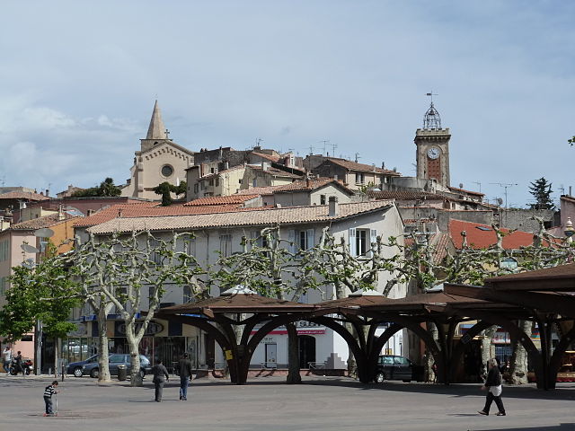
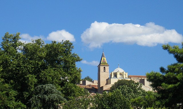
Роквер (Roquevaire, Roquevaire)

- коммуна во Франции
 Hiking in Роквер
Roquevaire is a charming commune located in the Provence-Alpes-Côte d'Azur region of France, known for its beautiful landscapes and rich natural environment. Here are some highlights and tips for hiking in Roquevaire:
Scenic Trails:
- The Sentier des Crêtes: This trail offers stunning panoramic views of the surrounding hills and valleys. It's a bit challenging but rewarding with its scenic vistas.
- Les Calanques: While not directly in Roquevaire, the nearby Calanques National Park is accessible for day hikes. Be sure to explore the rugged coastal paths and hidden coves.
- Montagne de la Sainte-Baume: Just a short drive from Roquevaire, this area features numerous trails leading through beautiful forests and past impressive cliffs.
Flora and Fauna:
- The region is rich in Mediterranean vegetation, including thyme, rosemary, and other aromatic plants.
- Wildlife is abundant, and if you're lucky, you might spot some local fauna like deer, foxes, or various bird species.
Hiking Tips:
- Preparation: Always check the weather before heading out, as conditions can change rapidly in mountainous areas.
- Hydration and Food: Bring plenty of water and snacks, as some trails may be remote.
- Footwear: Sturdy hiking boots are recommended due to rocky paths.
- Maps and Guides: It's helpful to have a local map or download a hiking app to keep track of trails and markings.
Accessibility:
Roquevaire is well-connected by road, making it easy to access local hiking trails. Public transport options may be limited, so a car could be necessary for reaching more remote hiking spots.
Safety:
As always when hiking, stay on marked trails, let someone know your hiking plans, and be mindful of your personal limits.
Exploring the natural beauty of Roquevaire and its surroundings can be a fantastic experience for hikers of all levels. Enjoy your adventure!
- Страна:

- Почтовый код: 13360
- Координаты: 43° 20' 58" N, 5° 36' 17" E


- GPS треки (wikiloc): [Ссылка]
- Высота над уровнем моря: 160 м m
- Площадь: 23.83 кв.км
- Население: 8939
- Веб сайт: http://www.ville-de-roquevaire.fr
- Википедия русская: wiki(ru)
- Википедия английская: wiki(en)
- Википедия национальная: wiki(fr)
- Хранилище Wikidata: Wikidata: Q640919
- Катеория в википедии: [Ссылка]
- код Freebase: [/m/0dlyct]
- код GeoNames: Альт: [2982835]
- номер SIREN: [211300868]
- код BNF: [152473685]
- код VIAF: Альт: [126771919]
- код LCNAF: Альт: [n88080585]
- EMLO location ID: [ef985a05-c743-46fd-91d0-9eb63615ec0c]
- код муниципалитета INSEE: 13086
Граничит с регионами:

Обань
- коммуна во Франции
- Страна:
- Почтовый код: 13400
- Координаты: 43° 17' 27" N, 5° 34' 15" E
- GPS треки (wikiloc): [Ссылка]
- Площадь: 54.9 кв.км
- Население: 45410
- Веб сайт: [Ссылка]


Жемнос
- коммуна во Франции
- Страна:
- Почтовый код: 13420
- Координаты: 43° 17' 46" N, 5° 37' 37" E
- GPS треки (wikiloc): [Ссылка]
- Площадь: 32.75 кв.км
- Население: 6387
- Веб сайт: [Ссылка]

Аллош
- коммуна во Франции
- Страна:
- Почтовый код: 13190
- Координаты: 43° 20' 10" N, 5° 28' 56" E
- GPS треки (wikiloc): [Ссылка]
- Площадь: 50.3 кв.км
- Население: 21332
- Веб сайт: [Ссылка]

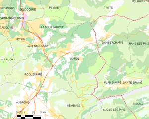
Орьоль
- коммуна в департаменте Буш-дю-Рон (Франция)
Hiking in Орьоль
Auriol, located in the Bouches-du-Rhône department in the Provence-Alpes-Côte d'Azur region of southern France, offers a variety of scenic hiking opportunities. Nestled between the Sainte-Baume mountains and the Calanques National Park, Auriol provides a beautiful backdrop with diverse landscapes, from hills and forests to rugged cliffs and Mediterranean flora....
- Страна:
- Почтовый код: 13390
- Координаты: 43° 22' 10" N, 5° 37' 53" E
- GPS треки (wikiloc): [Ссылка]
- Площадь: 44.64 кв.км
- Население: 11538
- Веб сайт: [Ссылка]


Ла-Деструс
- коммуна во Франции
Hiking in Ла-Деструс
La Destrousse is a charming village located in the Provence-Alpes-Côte d'Azur region of France. Nestled in the foothills of the Sainte-Baume mountains, it serves as a great starting point for various hiking opportunities in the surrounding area....
- Страна:
- Почтовый код: 13112
- Координаты: 43° 22' 35" N, 5° 36' 24" E
- GPS треки (wikiloc): [Ссылка]
- Площадь: 2.93 кв.км
- Население: 3381
- Веб сайт: [Ссылка]

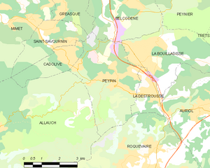
Пейпен
Hiking in Пейпен
Peypin is a charming commune located in the Bouches-du-Rhône department in the Provence-Alpes-Côte d'Azur region of France. It offers beautiful landscapes and a variety of hiking opportunities, making it a great destination for outdoor enthusiasts....
- Страна:
- Почтовый код: 13124
- Координаты: 43° 23' 9" N, 5° 34' 42" E
- GPS треки (wikiloc): [Ссылка]
- Площадь: 13.35 кв.км
- Население: 5454
- Веб сайт: [Ссылка]