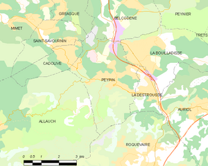
Сен-Савурнен (Saint-Savournin, Saint-Savournin)

- коммуна во Франции
 Hiking in Сен-Савурнен
Saint-Savournin is a charming village located in the Bouches-du-Rhône department of southern France, known for its scenic landscapes and proximity to the Sainte-Baume mountain range. Hiking in and around Saint-Savournin offers a variety of trails that cater to different skill levels, with beautiful views of the surrounding countryside and the Mediterranean climate providing pleasant hiking conditions for most of the year.
Popular Hiking Routes:
-
Sentier des Pêcheurs: This is a relatively easy trail that takes you near the local waterways and offers lovely scenic views. It’s suitable for families and beginners.
-
Colline de Saint-Savournin: Ascend to the nearby hills for more challenging hikes that reward you with stunning panoramic views of the region. The trails here may be steep in places but are well-marked.
-
Sainte-Baume Natural Regional Park: Just a short drive from Saint-Savournin, this park features numerous hiking trails through dense forests and limestone cliffs. Hikes vary from easy walks to more strenuous treks, catering to various hiking enthusiasts.
What to Keep in Mind:
-
Trail Conditions: Before heading out, it’s advisable to check the local trail conditions, as they can vary depending on the weather and recent rainfall.
-
Wildlife: The region is home to diverse wildlife, so be respectful of nature and carry out all your waste.
-
Local Amenities: Saint-Savournin has a few shops and cafes where you can stock up on supplies or enjoy a meal post-hike. It’s a good idea to bring plenty of water and snacks, especially for longer treks.
-
Safety: Always inform someone about your hiking plans, particularly if you are hiking alone. Bring a map or a GPS device and ensure your phone is charged for emergencies.
Enjoy your hiking adventure in Saint-Savournin! The area’s natural beauty and serene environment make it a wonderful place to connect with nature.
- Страна:

- Почтовый код: 13119
- Координаты: 43° 24' 23" N, 5° 31' 39" E


- GPS треки (wikiloc): [Ссылка]
- Площадь: 5.89 кв.км
- Население: 3315
- Веб сайт: http://www.saint-savournin.com
- Википедия русская: wiki(ru)
- Википедия английская: wiki(en)
- Википедия национальная: wiki(fr)
- Хранилище Wikidata: Wikidata: Q675839
- Катеория в википедии: [Ссылка]
- код Freebase: [/m/02822ls]
- код Freebase: [/m/02822ls]
- код GeoNames: Альт: [2976994]
- код GeoNames: Альт: [2976994]
- номер SIREN: [211301015]
- номер SIREN: [211301015]
- код BNF: [152473832]
- код BNF: [152473832]
- код VIAF: Альт: [243857763]
- код VIAF: Альт: [243857763]
- код GND: Альт: [4540986-9]
- код GND: Альт: [4540986-9]
- код тезауруса PACTOLS: [pcrtgqQvM32Lhk]
- код тезауруса PACTOLS: [pcrtgqQvM32Lhk]
- код муниципалитета INSEE: 13101
- код муниципалитета INSEE: 13101
Граничит с регионами:


Кадолив
- коммуна во Франции
Hiking in Кадолив
Cadolive, located in the Provence-Alpes-Côte d'Azur region of France, offers a beautiful setting for hiking enthusiasts. Here are some key points to consider when hiking in Cadolive:...
- Страна:
- Почтовый код: 13950
- Координаты: 43° 23' 43" N, 5° 32' 54" E
- GPS треки (wikiloc): [Ссылка]
- Площадь: 4.18 кв.км
- Население: 2158
- Веб сайт: [Ссылка]

Пейпен
Hiking in Пейпен
Peypin is a charming commune located in the Bouches-du-Rhône department in the Provence-Alpes-Côte d'Azur region of France. It offers beautiful landscapes and a variety of hiking opportunities, making it a great destination for outdoor enthusiasts....
- Страна:
- Почтовый код: 13124
- Координаты: 43° 23' 9" N, 5° 34' 42" E
- GPS треки (wikiloc): [Ссылка]
- Площадь: 13.35 кв.км
- Население: 5454
- Веб сайт: [Ссылка]


Миме
- коммуна во Франции
Hiking in Миме
Mimet, a picturesque village located in the Provence-Alpes-Côte d'Azur region of France, is known for its stunning landscapes and diverse hiking opportunities. Nestled at the foot of the Sainte-Baume mountain range, Mimet offers a variety of trails suitable for different skill levels, making it an excellent destination for hikers....
- Страна:
- Почтовый код: 13105
- Координаты: 43° 24' 49" N, 5° 30' 20" E
- GPS треки (wikiloc): [Ссылка]
- Площадь: 18.7 кв.км
- Население: 4607


Греаск
- коммуна во Франции
Hiking in Греаск
Gréasque, a charming commune in the Bouches-du-Rhône department of southern France, offers various hiking opportunities that showcase its beautiful landscapes and rich natural heritage. Nestled near the Sainte-Victoire mountain range, the area is characterized by picturesque hills, limestone formations, and Mediterranean vegetation. Here are some notable aspects of hiking in and around Gréasque:...
- Страна:
- Почтовый код: 13850
- Координаты: 43° 25' 50" N, 5° 32' 21" E
- GPS треки (wikiloc): [Ссылка]
- Площадь: 6.15 кв.км
- Население: 4111
- Веб сайт: [Ссылка]