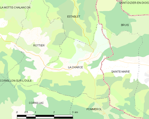
Сент-Мари (Sainte-Marie, Sainte-Marie)
 Hiking in Сент-Мари
Sainte-Marie, located in the Hautes-Alpes department in southeastern France, is a beautiful area known for its stunning alpine landscapes, clear lakes, and diverse flora and fauna. Here are some highlights and tips for hiking in and around Sainte-Marie:
Hiking Trails
-
Lautaret Pass and the Ecrins National Park: Just a short distance from Sainte-Marie, these areas offer numerous trails ranging from easy walks to challenging hikes. The landscape features rugged peaks, glaciers, and scenic valleys.
-
Col de l'Argentière: This is a popular hike with moderate difficulty. It provides spectacular views of the surrounding mountains and is a great spot for photography.
-
Lac de la Jarjatte: The trail to this lake is accessible and suitable for families. The lake is a wonderful spot to relax and enjoy a picnic, with hiking routes around it that can be explored.
-
Les Crêtes de la Molière: For more experienced hikers, this trail offers panoramic views and the chance to see local wildlife. The ridge provides a challenging ascent but rewards hikers with breathtaking vistas.
Best Time to Hike
- Summer (June to September): Most trails are open and accessible during this time, with mild temperatures and long daylight hours.
- Autumn (October): A great time for hiking due to the beautiful fall colors, but be prepared for cooler temperatures and shorter days.
- Winter (November to March): Some trails may be closed due to snow, but winter hiking and snowshoeing are popular in the region.
What to Bring
- Proper hiking boots: The terrain can be rugged.
- Plenty of water and snacks: Ensure you stay hydrated and energized.
- A detailed map or GPS: Although trails are marked, having a map can help you stay oriented.
- Weather-appropriate clothing: Conditions can change quickly in the mountains.
Safety Tips
- Inform someone about your hiking plans and expected return time.
- Check the weather forecast before you go.
- Be prepared for altitude changes; acclimatization is important if you are hiking at higher elevations.
- Make sure you have a first-aid kit and know basic first aid procedures.
Conclusion
Hiking in Sainte-Marie, Hautes-Alpes, offers a unique opportunity to explore the natural beauty of the French Alps, catering to hikers of all skill levels. Whether you're looking for a leisurely stroll by a lake or a challenging summit climb, you’ll find a variety of trails to enjoy. Always prioritize safety and be respectful of the natural environment to ensure a delightful hiking experience.
- Страна:

- Почтовый код: 05150
- Координаты: 44° 27' 56" N, 5° 28' 30" E


- GPS треки (wikiloc): [Ссылка]
- Площадь: 7.5 кв.км
- Население: 40
- Википедия русская: wiki(ru)
- Википедия английская: wiki(en)
- Википедия национальная: wiki(fr)
- Хранилище Wikidata: Wikidata: Q1085911
- Катеория в википедии: [Ссылка]
- код Freebase: [/m/03m821p]
- код Freebase: [/m/03m821p]
- код GeoNames: Альт: [6453563]
- код GeoNames: Альт: [6453563]
- номер SIREN: [210501508]
- номер SIREN: [210501508]
- код VIAF: Альт: [312727096]
- код VIAF: Альт: [312727096]
- код LCNAF: Альт: [n85221283]
- код LCNAF: Альт: [n85221283]
- код ISNI: Альт: [0000 0000 9169 3674]
- код ISNI: Альт: [0000 0000 9169 3674]
- код муниципалитета INSEE: 05150
- код муниципалитета INSEE: 05150
Граничит с регионами:

Брюи
Hiking in Брюи
Bruis, a charming village in France's Hautes-Alpes region, offers a range of beautiful hiking opportunities that take advantage of the stunning Alpine scenery. Here are some key points to consider when hiking in and around Bruis:...
- Страна:
- Почтовый код: 05150
- Координаты: 44° 28' 5" N, 5° 30' 49" E
- GPS треки (wikiloc): [Ссылка]
- Площадь: 25.15 кв.км
- Население: 77


Pommerol
- коммуна во Франции
Hiking in Pommerol
Pommerol, located in the heart of the French Alps, is a charming destination for hiking enthusiasts. The region is known for its stunning landscapes, diverse terrains, and picturesque villages. Here are some highlights and tips for hiking in Pommerol:...
- Страна:
- Почтовый код: 26470
- Координаты: 44° 26' 46" N, 5° 27' 8" E
- GPS треки (wikiloc): [Ссылка]
- Высота над уровнем моря: 890 м m
- Площадь: 9.83 кв.км
- Население: 20

La Charce
- коммуна во Франции
Hiking in La Charce
La Charce is a beautiful area located in the southern region of the Drôme department in France. It's known for its stunning landscapes, diverse flora and fauna, and serene hiking trails. Here’s some information to help you plan your hiking adventure in La Charce:...
- Страна:
- Почтовый код: 26470
- Координаты: 44° 28' 14" N, 5° 27' 3" E
- GPS треки (wikiloc): [Ссылка]
- Площадь: 9.43 кв.км
- Население: 35