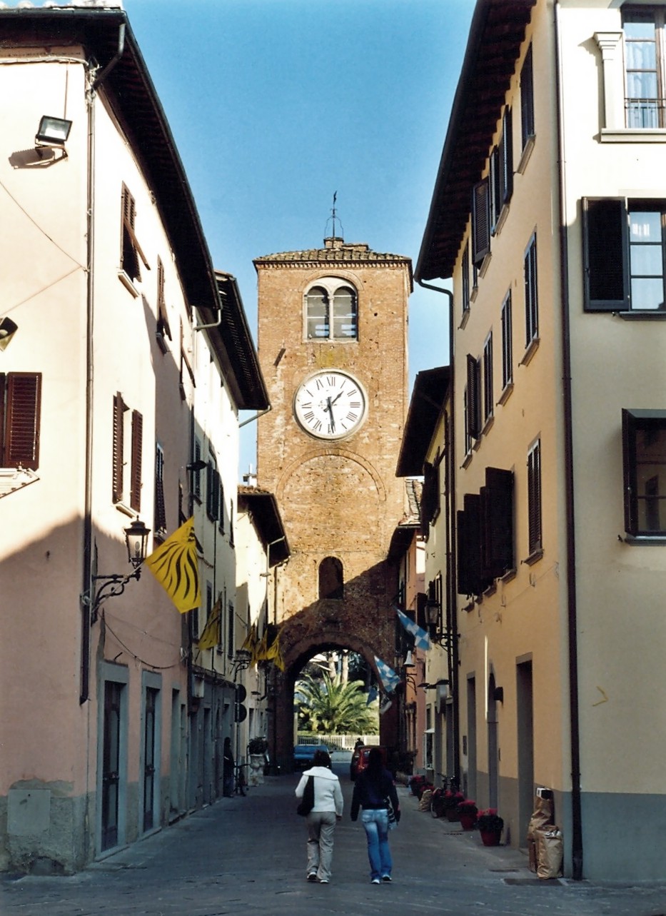
Сан-Миниато (San Miniato, San Miniato)
.svg)
- коммуна Италии
 Hiking in Сан-Миниато
San Miniato, located in the Tuscany region of Italy, is a charming town known for its historical significance, beautiful landscapes, and rich culture. Hiking in and around San Miniato offers a blend of scenic views, nature, and cultural experiences. Here are some highlights to consider:
Trails and Routes
-
Via Francigena: This ancient pilgrimage route runs through San Miniato and offers numerous sections to hike. The scenery varies from rolling hills to vineyards and olive groves, providing a glimpse into Tuscany’s rural beauty.
-
San Miniato Hills: Surrounding the town, the hills offer various trails of differing difficulties. You can enjoy panoramic views of the town and the surrounding landscape. Some trails are suitable for leisurely walks, while others can be more challenging.
-
Cultural Hikes: Combine hiking with cultural exploration by visiting historic sites along the way, such as the San Miniato Cathedral and the Fortress. These landmarks add rich context to your hike.
Best Time to Hike
- Spring (March to June) and Fall (September to November): These seasons offer mild weather and beautiful scenery with blooming wildflowers or autumn foliage, making them ideal for hiking.
What to Bring
- Water: Stay hydrated, especially on longer hikes.
- Snacks: Pack some energy-boosting snacks for your journey.
- Comfortable Shoes: Good hiking boots or shoes are essential for uneven terrain.
- Sun Protection: Sunglasses, a hat, and sunscreen are recommended, especially in the summer months.
- Map/Guide: Having a map or a hiking app can help you navigate the trails.
Local Wildlife and Flora
Hiking around San Miniato provides opportunities to see local flora and fauna, including Mediterranean plants, wildflowers, and possibly even some wildlife like deer or various bird species.
Safety Tips
- Always inform someone of your hiking plans.
- Check the weather beforehand.
- Stay on marked trails and be cautious of potentially hazardous terrain.
Conclusion
Hiking in San Miniato can be a rewarding experience, blending physical activity with the enjoyment of natural and historical beauty. Whether you are seeking solitude in nature or a more cultural experience, there are diverse options to explore the enchanting Tuscan landscape.
- Страна:

- Почтовый код: 56028
- Телефонный код: 0571
- Код автомобильного номера: PI
- Координаты: 43° 41' 0" N, 10° 51' 0" E


- GPS треки (wikiloc): [Ссылка]
- Высота над уровнем моря: 140 м m
- Площадь: 102.5 кв.км
- Население: 27950
- Веб сайт: http://www.comune.san-miniato.pi.it
- Википедия русская: wiki(ru)
- Википедия английская: wiki(en)
- Википедия национальная: wiki(it)
- Хранилище Wikidata: Wikidata: Q103244
- Галерея изображений в википедии: [Ссылка]
- Катеория в википедии: [Ссылка]
- код Freebase: [/m/09nzjz]
- код GeoNames: Альт: [6542091]
- код BNF: [12239808j]
- код VIAF: Альт: [240381758]
- ID отношения в OpenStreetMap: [42546]
- идентификатор местоположения ArchINFORM: [45499]
- место в MusicBrainz: [dc959f39-054a-4424-acaf-cc76722cd4d7]
- UN/LOCODE: [ITSMI]
- код места в Facebook: [108437845847226]
- код Католической энциклопедии: [13449c]
- код ISTAT: 050032
- кадастровый код Италии: I046
Граничит с регионами:
Кастельфранко-ди-Сотто
- коммуна Италии
Hiking in Кастельфранко-ди-Сотто
Castelfranco di Sotto is a charming town located in the Tuscany region of Italy, known for its rich history, beautiful landscapes, and proximity to the Lucca and Pisa provinces. While the town itself is not a major hiking destination, it offers access to several nearby trails and natural areas that are perfect for hiking enthusiasts....
- Страна:
- Почтовый код: 56022
- Телефонный код: 0571
- Код автомобильного номера: PI
- Координаты: 43° 42' 0" N, 10° 45' 0" E
- GPS треки (wikiloc): [Ссылка]
- Высота над уровнем моря: 16 м m
- Площадь: 48.33 кв.км
- Население: 13396
- Веб сайт: [Ссылка]

Монтополи-ин-Валь-д'Арно
- коммуна Италии
Hiking in Монтополи-ин-Валь-д'Арно
Montopoli in Val d'Arno is a picturesque town located in the Tuscany region of Italy. Nestled in the beautiful Val d'Arno area between Florence and Pisa, it offers a range of hiking opportunities that showcase the stunning landscapes and cultural heritage of the region. Here are some tips and highlights for hiking in and around Montopoli:...
- Страна:
- Почтовый код: 56020
- Телефонный код: 0571
- Код автомобильного номера: PI
- Координаты: 43° 40' 28" N, 10° 45' 1" E
- GPS треки (wikiloc): [Ссылка]
- Высота над уровнем моря: 98 м m
- Площадь: 30.22 кв.км
- Население: 11149
- Веб сайт: [Ссылка]

Палая
- коммуна Италии
Hiking in Палая
Palaia, located in the Pisa Province of Tuscany, Italy, offers beautiful hiking opportunities set against a backdrop of rolling hills, vineyards, and charming medieval villages. Here are some key points to consider for hiking in the area:...
- Страна:
- Почтовый код: 56036
- Телефонный код: 0587
- Код автомобильного номера: PI
- Координаты: 43° 36' 21" N, 10° 46' 22" E
- GPS треки (wikiloc): [Ссылка]
- Высота над уровнем моря: 240 м m
- Площадь: 73.71 кв.км
- Население: 4542
- Веб сайт: [Ссылка]
Санта-Кроче-сулл'Арно
- коммуна Италии
Hiking in Санта-Кроче-сулл'Арно
Santa Croce sull'Arno is a charming town situated in the Tuscany region of Italy, known for its beautiful landscapes and rich cultural heritage. The area around Santa Croce offers various hiking opportunities that allow you to explore the scenic beauty of the Tuscan countryside....
- Страна:
- Почтовый код: 56029
- Телефонный код: 0571
- Код автомобильного номера: PI
- Координаты: 43° 43' 13" N, 10° 46' 22" E
- GPS треки (wikiloc): [Ссылка]
- Высота над уровнем моря: 18 м m
- Площадь: 16.79 кв.км
- Население: 14627
- Веб сайт: [Ссылка]

Эмполи
- коммуна Италии
Hiking in Эмполи
Empoli, located in the Tuscany region of Italy, is not only known for its rich history and culture but also offers a variety of hiking opportunities thanks to its beautiful landscapes, rolling hills, and proximity to the Arno River. Here are some details that can guide you if you're looking to hike in and around Empoli:...
- Страна:
- Почтовый код: 50053
- Телефонный код: 0571
- Код автомобильного номера: FI
- Координаты: 43° 43' 0" N, 10° 57' 0" E
- GPS треки (wikiloc): [Ссылка]
- Высота над уровнем моря: 28 м m
- Площадь: 62.21 кв.км
- Население: 48626
- Веб сайт: [Ссылка]

Кастельфьорентино
- коммуна Италии
Hiking in Кастельфьорентино
Castelfiorentino, located in the heart of Tuscany, Italy, is surrounded by beautiful landscapes that offer wonderful hiking opportunities. Nestled between the larger towns of Florence and Siena, it provides hikers with a mix of historic charm and natural beauty....
- Страна:
- Почтовый код: 50051
- Телефонный код: 0571
- Код автомобильного номера: FI
- Координаты: 43° 36' 39" N, 10° 58' 12" E
- GPS треки (wikiloc): [Ссылка]
- Высота над уровнем моря: 50 м m
- Площадь: 66.56 кв.км
- Население: 17283
- Веб сайт: [Ссылка]

Черрето-Гуйди
- коммуна Италии
Hiking in Черрето-Гуйди
Cerreto Guidi, located in the Tuscany region of Italy, is a charming town known for its beautiful countryside, historical significance, and proximity to a variety of outdoor activities, including hiking. Here are some key points to consider for hiking in Cerreto Guidi:...
- Страна:
- Почтовый код: 50050
- Телефонный код: 0571
- Код автомобильного номера: FI
- Координаты: 43° 45' 42" N, 10° 52' 38" E
- GPS треки (wikiloc): [Ссылка]
- Высота над уровнем моря: 123 м m
- Площадь: 49.32 кв.км
- Население: 11010
- Веб сайт: [Ссылка]

Фучеккьо
- коммуна Италии
Hiking in Фучеккьо
Fucecchio, located in Tuscany, Italy, offers some beautiful hiking opportunities, characterized by its picturesque landscapes that include rolling hills, vineyards, and charming historical towns. The area is also known for its rich biodiversity, especially in the regional park of the Padule di Fucecchio, which is a protected marshland home to various bird species and other wildlife....
- Страна:
- Почтовый код: 50054
- Телефонный код: 0571
- Код автомобильного номера: FI
- Координаты: 43° 44' 0" N, 10° 48' 0" E
- GPS треки (wikiloc): [Ссылка]
- Высота над уровнем моря: 25 м m
- Площадь: 65.18 кв.км
- Население: 23275
- Веб сайт: [Ссылка]

Монтайоне
- коммуна Италии
Hiking in Монтайоне
Montaione, located in the Tuscany region of Italy, is a hidden gem for hikers looking to explore the beautiful Italian countryside. It's surrounded by rolling hills, vineyards, olive groves, and picturesque medieval towns, providing a variety of trails suitable for different skill levels....
- Страна:
- Почтовый код: 50050
- Телефонный код: 0571
- Код автомобильного номера: FI
- Координаты: 43° 33' 12" N, 10° 54' 42" E
- GPS треки (wikiloc): [Ссылка]
- Высота над уровнем моря: 342 м m
- Площадь: 104.76 кв.км
- Население: 3638
- Веб сайт: [Ссылка]