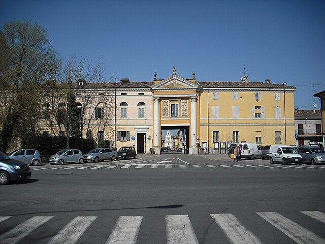
Сант'Агата-Болоньезе (Sant'Agata Bolognese, Sant'Agata Bolognese)
.svg)
- коммуна Италии
 Hiking in Сант'Агата-Болоньезе
Sant'Agata Bolognese is a charming village located in the Emilia-Romagna region of Italy, and while it may not be widely known as a hiking destination, it offers a few opportunities to enjoy the beautiful Italian countryside.
Hiking Opportunities:
-
Countryside Trails: The area around Sant'Agata Bolognese features rolling hills, farmland, and scenic views. You can explore local trails that wind through vineyards, fields, and small forested areas, providing a peaceful environment for a leisurely hike.
-
Historical Routes: Given the rich history of the Emilia-Romagna region, some trails may lead you to historical sites, churches, and rural homes that date back centuries. Exploring these paths can also provide insight into the local culture and architecture.
-
Nearby Parks and Nature Reserves: Some natural areas near Sant'Agata Bolognese, like the Parco Regionale dell'Abbazia di Monteveglio, offer more structured hiking trails. These parks often feature diverse flora and fauna, picnic areas, and sometimes guided tours.
-
Connecting Trails: You can connect with longer distance trails that are part of broader hiking networks in Emilia-Romagna. If you’re up for more extensive hiking, consider planning a route that includes these longer paths.
Tips for Hiking in the Area:
- Footwear: Choose comfortable hiking shoes that provide good ankle support, as the terrain can vary from paved paths to uneven ground.
- Weather: Check the weather forecast before heading out and dress in layers. Temperatures can vary, especially in spring and fall.
- Navigation: Familiarize yourself with local maps or use a GPS device or hiking app to ensure you stay on track.
- Water and Snacks: Bring enough water and snacks, especially if hiking longer distances or in remote areas.
- Local Cuisine: After your hike, consider indulging in local cuisine—Emilia-Romagna is renowned for its delicious food and wines.
While Sant'Agata Bolognese may not be a mainstream hiking destination, taking the time to explore its surroundings can provide a unique experience and a glimpse into the rural Italian lifestyle.
- Страна:

- Почтовый код: 40019
- Телефонный код: 051
- Код автомобильного номера: BO
- Координаты: 44° 40' 0" N, 11° 8' 0" E


- GPS треки (wikiloc): [Ссылка]
- Высота над уровнем моря: 21 м m
- Площадь: 34.79 кв.км
- Население: 7344
- Веб сайт: http://www.comune.santacaterinadelloionio.cz.it
- Википедия русская: wiki(ru)
- Википедия английская: wiki(en)
- Википедия национальная: wiki(it)
- Хранилище Wikidata: Wikidata: Q94996
- Катеория в википедии: [Ссылка]
- код Freebase: [/m/07cbnp]
- код GeoNames: Альт: [6536745]
- код VIAF: Альт: [243046324]
- ID отношения в OpenStreetMap: [43429]
- место в MusicBrainz: [24806e04-18b7-4299-9e42-8e9c86ae51b8]
- UN/LOCODE: [ITSBN]
- код ISTAT: 037056
- кадастровый код Италии: I191
Граничит с регионами:


Кастельфранко-Эмилия
- коммуна Италии
Hiking in Кастельфранко-Эмилия
Castelfranco Emilia, located in the Emilia-Romagna region of northern Italy, is not only known for its beautiful architecture and history but also for its scenic landscapes and opportunities for hiking. Although it may not be as famous for hiking as some Italian regions, there are still several trails and natural spots nearby that can offer a charming experience for hikers....
- Страна:
- Почтовый код: 41013
- Телефонный код: 059
- Код автомобильного номера: MO
- Координаты: 44° 35' 48" N, 11° 3' 10" E
- GPS треки (wikiloc): [Ссылка]
- Высота над уровнем моря: 42 м m
- Площадь: 102.51 кв.км
- Население: 32894
- Веб сайт: [Ссылка]


Нонантола
- коммуна Италии
Hiking in Нонантола
Nonantola, located in the Emilia-Romagna region of Italy, is a charming town that offers a variety of hiking opportunities in the surrounding areas. While Nonantola itself is not known for dramatic mountain trails, the region offers scenic walks through countryside landscapes, lush vineyards, and historical sites....
- Страна:
- Почтовый код: 41015
- Телефонный код: 059
- Код автомобильного номера: MO
- Координаты: 44° 40' 40" N, 11° 2' 35" E
- GPS треки (wikiloc): [Ссылка]
- Высота над уровнем моря: 20 м m
- Площадь: 55.32 кв.км
- Население: 15957
- Веб сайт: [Ссылка]

Кревалькоре
- коммуна Италии
Hiking in Кревалькоре
Crevalcore is a charming town located in the Emilia-Romagna region of Italy, known more for its agricultural landscape than for traditional hiking trails. However, there are opportunities for easy hiking and walking in the surrounding countryside....
- Страна:
- Почтовый код: 40014
- Телефонный код: 051
- Код автомобильного номера: BO
- Координаты: 44° 43' 0" N, 11° 9' 0" E
- GPS треки (wikiloc): [Ссылка]
- Высота над уровнем моря: 20 м m
- Площадь: 102.75 кв.км
- Население: 13501
- Веб сайт: [Ссылка]

Сан-Джованни-ин-Персичето
- коммуна Италии
Hiking in Сан-Джованни-ин-Персичето
San Giovanni in Persiceto, located in the Emilia-Romagna region of Italy, offers beautiful landscapes and scenic routes that attract hikers looking to explore the rustic charm of the area. While the town itself is known for its historical architecture and cultural heritage, the surrounding countryside provides several opportunities for hiking and outdoor activities....
- Страна:
- Почтовый код: 40017
- Телефонный код: 051
- Код автомобильного номера: BO
- Координаты: 44° 38' 27" N, 11° 11' 6" E
- GPS треки (wikiloc): [Ссылка]
- Высота над уровнем моря: 21 м m
- Площадь: 114.41 кв.км
- Население: 28153
- Веб сайт: [Ссылка]