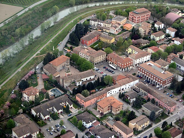
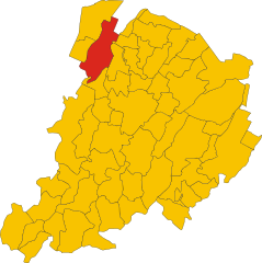
Кревалькоре (Crevalcore, Crevalcore)
.svg)
- коммуна Италии
 Hiking in Кревалькоре
Crevalcore is a charming town located in the Emilia-Romagna region of Italy, known more for its agricultural landscape than for traditional hiking trails. However, there are opportunities for easy hiking and walking in the surrounding countryside.
Hiking Options in and around Crevalcore:
-
Countryside Trails: The flat terrain around Crevalcore offers various paths that wind through fields and farmlands. These trails are suitable for leisurely walks and can be a great way to experience the rural landscape of the region.
-
Po Delta Park: A bit farther from Crevalcore, but within reachable distance, is the Po Delta Regional Park. This area has designated hiking trails, where you can explore wetlands, lagoons, and discover diverse wildlife. The park offers a unique ecosystem and beautiful scenery.
-
Regional Routes: You could also connect with regional walking or cycling routes that may extend to nearby towns and natural areas, allowing for a more extended hiking experience.
-
Local Parks: Check for local parks in and around Crevalcore, which may have marked walking trails and serene spots for a short hike or picnic.
Tips for Hiking in Crevalcore:
-
Weather Preparedness: Always check the weather before heading out and dress in layers, as conditions can change.
-
Footwear: Wear comfortable hiking shoes, especially if you plan on exploring unpaved paths.
-
Hydration and Snacks: Bring water and snacks, especially if you're embarking on a longer walk.
-
Local Guidance: Consider contacting local tourism offices for maps, trail guides, and recommendations on safe and scenic routes.
-
Respect Nature: Stay on marked trails and follow local guidelines to protect the environment.
Conclusion
While Crevalcore itself may not have extensive hiking opportunities, the surrounding areas provide a peaceful setting for walking and enjoying nature. Whether you're looking for a quick stroll or a more immersive experience in the Emilia-Romagna countryside, there are options available for every comfort level.
- Страна:

- Почтовый код: 40014
- Телефонный код: 051
- Код автомобильного номера: BO
- Координаты: 44° 43' 0" N, 11° 9' 0" E


- GPS треки (wikiloc): [Ссылка]
- Высота над уровнем моря: 20 м m
- Площадь: 102.75 кв.км
- Население: 13501
- Веб сайт: http://www.comune.crevalcore.bo.it
- Википедия русская: wiki(ru)
- Википедия английская: wiki(en)
- Википедия национальная: wiki(it)
- Хранилище Wikidata: Wikidata: Q94801
- Катеория в википедии: [Ссылка]
- код Freebase: [/m/083h7b]
- код GeoNames: Альт: [6538468]
- код VIAF: Альт: [247843683]
- ID отношения в OpenStreetMap: [43494]
- идентификатор местоположения ArchINFORM: [43039]
- место в MusicBrainz: [b80f5d6a-01a8-420c-9eee-ab46d05af104]
- WOEID: [714839]
- UN/LOCODE: [ITCVB]
- код Цифрового атласа Римской империи: [17824]
- код ISTAT: 037024
- кадастровый код Италии: D166
Граничит с регионами:

Кампозанто
- коммуна Италии
Hiking in Кампозанто
Camposanto, often referred to as Camposanto Monumentale, is not primarily known as a hiking destination but rather as a cemetery located in Pisa, Italy, renowned for its sculpture and art. However, if you are looking for hiking opportunities in the broader Tuscan region, here are some suggestions:...
- Страна:
- Почтовый код: 41031
- Телефонный код: 0535
- Код автомобильного номера: MO
- Координаты: 44° 47' 0" N, 11° 8' 0" E
- GPS треки (wikiloc): [Ссылка]
- Высота над уровнем моря: 21 м m
- Площадь: 22.71 кв.км
- Население: 3049
- Веб сайт: [Ссылка]


Финале-Эмилия
- коммуна Италии
Hiking in Финале-Эмилия
Finale Emilia, located in the Emilia-Romagna region of Italy, is not primarily known as a hiking destination compared to the surrounding areas that are more mountainous. However, it offers some pleasant opportunities for walking and enjoying the natural scenery....
- Страна:
- Почтовый код: 41034
- Телефонный код: 0535
- Код автомобильного номера: MO
- Координаты: 44° 49' 55" N, 11° 17' 45" E
- GPS треки (wikiloc): [Ссылка]
- Высота над уровнем моря: 15 м m
- Площадь: 105.13 кв.км
- Население: 15581
- Веб сайт: [Ссылка]


Нонантола
- коммуна Италии
Hiking in Нонантола
Nonantola, located in the Emilia-Romagna region of Italy, is a charming town that offers a variety of hiking opportunities in the surrounding areas. While Nonantola itself is not known for dramatic mountain trails, the region offers scenic walks through countryside landscapes, lush vineyards, and historical sites....
- Страна:
- Почтовый код: 41015
- Телефонный код: 059
- Код автомобильного номера: MO
- Координаты: 44° 40' 40" N, 11° 2' 35" E
- GPS треки (wikiloc): [Ссылка]
- Высота над уровнем моря: 20 м m
- Площадь: 55.32 кв.км
- Население: 15957
- Веб сайт: [Ссылка]
Раварино
- коммуна Италии
Hiking in Раварино
Ravarino is a small town located in the Emilia-Romagna region of Italy, known for its scenic countryside and proximity to larger cities like Modena and Bologna. While Ravarino itself might not be famous for high-profile hiking trails, the surrounding landscapes offer opportunities for nature lovers and hikers looking to explore the beautiful Italian countryside....
- Страна:
- Почтовый код: 41017
- Телефонный код: 059
- Код автомобильного номера: MO
- Координаты: 44° 43' 0" N, 11° 6' 0" E
- GPS треки (wikiloc): [Ссылка]
- Высота над уровнем моря: 23 м m
- Площадь: 28.53 кв.км
- Население: 6132
- Веб сайт: [Ссылка]

Сан-Джованни-ин-Персичето
- коммуна Италии
Hiking in Сан-Джованни-ин-Персичето
San Giovanni in Persiceto, located in the Emilia-Romagna region of Italy, offers beautiful landscapes and scenic routes that attract hikers looking to explore the rustic charm of the area. While the town itself is known for its historical architecture and cultural heritage, the surrounding countryside provides several opportunities for hiking and outdoor activities....
- Страна:
- Почтовый код: 40017
- Телефонный код: 051
- Код автомобильного номера: BO
- Координаты: 44° 38' 27" N, 11° 11' 6" E
- GPS треки (wikiloc): [Ссылка]
- Высота над уровнем моря: 21 м m
- Площадь: 114.41 кв.км
- Население: 28153
- Веб сайт: [Ссылка]
Сант'Агата-Болоньезе
- коммуна Италии
Hiking in Сант'Агата-Болоньезе
Sant'Agata Bolognese is a charming village located in the Emilia-Romagna region of Italy, and while it may not be widely known as a hiking destination, it offers a few opportunities to enjoy the beautiful Italian countryside....
- Страна:
- Почтовый код: 40019
- Телефонный код: 051
- Код автомобильного номера: BO
- Координаты: 44° 40' 0" N, 11° 8' 0" E
- GPS треки (wikiloc): [Ссылка]
- Высота над уровнем моря: 21 м m
- Площадь: 34.79 кв.км
- Население: 7344
- Веб сайт: [Ссылка]


Ченто
- коммуна Италии
Hiking in Ченто
Cento is a town located in the Emilia-Romagna region of northern Italy, known more for its historical significance and cultural sites than for extensive hiking trails. However, if you're looking to explore the natural beauty of the surrounding areas, there are a few options you might consider....
- Страна:
- Почтовый код: 44042
- Телефонный код: 051
- Код автомобильного номера: FE
- Координаты: 44° 44' 0" N, 11° 17' 0" E
- GPS треки (wikiloc): [Ссылка]
- Высота над уровнем моря: 15 м m
- Площадь: 64.74 кв.км
- Население: 35547
- Веб сайт: [Ссылка]