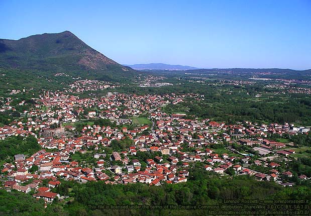
Сант-Амброджо-ди-Торино (Sant'Ambrogio di Torino, Sant'Ambrogio di Torino)

- коммуна в Италии
 Hiking in Сант-Амброджо-ди-Торино
Sant'Ambrogio di Torino, located in the Susa Valley of the Piedmont region in Italy, offers a range of scenic hiking opportunities. The area provides beautiful landscapes, diverse flora and fauna, and a taste of local culture. Here are some highlights and tips for hiking in and around Sant'Ambrogio di Torino:
Hiking Trails
-
Col di Fenestrelle: This trail leads you towards the Fenestrelle fortress and offers stunning views of the surrounding mountains. The trail can be moderately demanding, making it suitable for experienced hikers.
-
Sentiero degli Alpini: A well-marked path that showcases the breathtaking scenery of the Susa Valley. It’s a great choice for families and provides various viewpoints.
-
Trail to Monte Cuneo: This hike takes you to Monte Cuneo, rewarding you with expansive views of the Alps. The trail can be challenging, featuring steep sections.
-
Parco Naturale del Gran Bosco di Salbertrand: Just a short drive from Sant'Ambrogio, this natural park offers a variety of trails suitable for different skill levels, surrounded by rich biodiversity.
Preparation Tips
- Maps and Guides: Make sure to carry a detailed map or guide, as some trails may not be well-marked.
- Weather Conditions: Always check the weather forecast before heading out. Conditions can change rapidly in the mountains.
- Gear: Wear appropriate hiking shoes, and bring essentials such as water, snacks, and a first-aid kit.
- Local Regulations: Respect local wildlife and follow any guidelines in natural parks.
Cultural Aspects
Hiking in Sant'Ambrogio di Torino also provides opportunities to explore local history and culture. The area is rich in historical sites, including churches and traditional villages, which you can visit along the way.
Best Time to Hike
The best times for hiking in this region are during the spring (April to June) and the fall (September to October) when the weather is mild and the trails are less crowded.
By combining beautiful hiking paths with cultural experiences, Sant'Ambrogio di Torino can be a fantastic destination for outdoor enthusiasts and those looking to explore the natural beauty of Italy.
- Страна:

- Почтовый код: 10057
- Телефонный код: 011
- Код автомобильного номера: TO
- Координаты: 45° 6' 0" N, 7° 22' 0" E


- GPS треки (wikiloc): [Ссылка]
- Высота над уровнем моря: 356 м m
- Площадь: 8.37 кв.км
- Население: 4735
- Веб сайт: http://www.comune.santambrogioditorino.to.it/
- Википедия русская: wiki(ru)
- Википедия английская: wiki(en)
- Википедия национальная: wiki(it)
- Хранилище Wikidata: Wikidata: Q10291
- Катеория в википедии: [Ссылка]
- код Freebase: [/m/0g8lxj]
- код GeoNames: Альт: [6538083]
- код VIAF: Альт: [143536066]
- ID отношения в OpenStreetMap: [44184]
- код TGN: [5002716]
- UN/LOCODE: [ITMBO]
- код в Итальянской энциклопедии онлайн: [sant-ambrogio-di-torino]
- код ISTAT: 001255
- кадастровый код Италии: I258
Граничит с регионами:


Вальджойе
- коммуна в Италии
Hiking in Вальджойе
Valgioie, located in the Susa Valley in the Piedmont region of Italy, offers a range of hiking opportunities that showcase its beautiful landscapes, rich flora, and stunning views of the surrounding mountains. The area is known for its natural beauty and is less crowded than some other tourist hotspots, making it a perfect destination for hiking enthusiasts looking for a peaceful experience in nature....
- Страна:
- Почтовый код: 10094
- Телефонный код: 011
- Код автомобильного номера: TO
- Координаты: 45° 5' 0" N, 7° 20' 0" E
- GPS треки (wikiloc): [Ссылка]
- Высота над уровнем моря: 870 м m
- Площадь: 9.12 кв.км
- Население: 973
- Веб сайт: [Ссылка]

Виллар-Дора
- коммуна в Италии
Hiking in Виллар-Дора
Villar Dora is a small town located in the Susa Valley in the Piedmont region of northern Italy. It’s surrounded by stunning mountainous landscapes, making it an excellent destination for hiking enthusiasts. Here are some highlights regarding hiking in and around Villar Dora:...
- Страна:
- Почтовый код: 10040
- Телефонный код: 011
- Код автомобильного номера: TO
- Координаты: 45° 7' 0" N, 7° 23' 0" E
- GPS треки (wikiloc): [Ссылка]
- Высота над уровнем моря: 367 м m
- Площадь: 5.71 кв.км
- Население: 2897
- Веб сайт: [Ссылка]


Авильяна
- коммуна Италии
Hiking in Авильяна
Avigliana is a charming town located in the province of Turin, Italy, and it's known for its beautiful natural landscapes, particularly the Avigliana Lakes (Laghi di Avigliana) and the surrounding hills and mountains. The area offers a variety of hiking trails suitable for different skill levels, making it a great destination for outdoor enthusiasts....
- Страна:
- Почтовый код: 10051
- Телефонный код: 011
- Код автомобильного номера: TO
- Координаты: 45° 4' 46" N, 7° 23' 46" E
- GPS треки (wikiloc): [Ссылка]
- Высота над уровнем моря: 383 м m
- Площадь: 23.22 кв.км
- Население: 12443
- Веб сайт: [Ссылка]


Каприе
- коммуна Италии
Hiking in Каприе
Caprie is a charming town located in the Piedmont region of Italy, surrounded by beautiful landscapes and offers various hiking opportunities for outdoor enthusiasts. While it may not be as popular as some other hiking destinations in Italy, it provides a unique experience characterized by its scenic routes, cultural heritage, and relatively less crowded trails....
- Страна:
- Почтовый код: 10040
- Телефонный код: 011
- Код автомобильного номера: TO
- Координаты: 45° 7' 0" N, 7° 19' 0" E
- GPS треки (wikiloc): [Ссылка]
- Высота над уровнем моря: 375 м m
- Площадь: 16.41 кв.км
- Население: 2087
- Веб сайт: [Ссылка]


Кьюза-ди-Сан-Микеле
- коммуна Италии
Hiking in Кьюза-ди-Сан-Микеле
Chiusa di San Michele, located in the Susa Valley in the Piedmont region of Italy, is a fantastic hiking destination known for its stunning landscapes, historical significance, and diverse trails. The area includes scenic views of the surrounding mountains and valleys, as well as charming villages and rich cultural heritage....
- Страна:
- Почтовый код: 10050
- Телефонный код: 011
- Код автомобильного номера: TO
- Координаты: 45° 6' 0" N, 7° 19' 0" E
- GPS треки (wikiloc): [Ссылка]
- Высота над уровнем моря: 378 м m
- Площадь: 5.92 кв.км
- Население: 1667
- Веб сайт: [Ссылка]