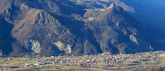
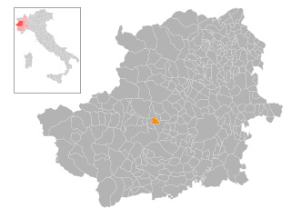
Виллар-Дора (Villar Dora, Villar Dora)

- коммуна в Италии
 Hiking in Виллар-Дора
Villar Dora is a small town located in the Susa Valley in the Piedmont region of northern Italy. It’s surrounded by stunning mountainous landscapes, making it an excellent destination for hiking enthusiasts. Here are some highlights regarding hiking in and around Villar Dora:
Trails:
-
Local Trails: Villar Dora has several marked hiking trails that range in difficulty, suitable for both beginners and experienced hikers. You can find routes that lead through lush forests, along rivers, and up to panoramic viewpoints.
-
Susa Valley Trails: The trails in the wider Susa Valley offer a variety of landscapes, from gentle walks to more challenging hikes with steep ascents. Popular trails nearby include those leading to the Rocciamelone and various paths around the Gran Bosco di Salbertrand natural park.
-
Historical and Cultural Routes: Along with natural beauty, some trails may lead you to historical sites, including ancient churches, castles, and remnants of old trade routes. Exploring these trails can provide a glimpse into the region's cultural heritage.
Best Times to Hike:
- Spring and Fall: The weather during these seasons tends to be mild, making it an ideal time for hiking. Spring showcases blooming wildflowers, while fall offers stunning foliage.
- Summer: Summer can be warm but provides longer daylight hours, perfect for day-long hikes. Just remember to bring plenty of water and sun protection.
Precautions:
- Preparation: Always check trail conditions and weather forecasts before heading out. Bring suitable gear, including good hiking boots, a map or GPS device, and sufficient water and snacks.
- Wildlife: The area is also home to various wildlife, so it's important to stay on marked trails and respect nature.
Additional Activities:
- Biking: Many hiking trails are also suitable for mountain biking.
- Climbing and Via Ferrata: For more adventure, look into climbing routes and via ferratas in the surrounding mountains.
Getting There:
Villar Dora is accessible by car and public transportation, with several connections from Turin. If you're flying in, Turin's airport is the nearest major airport.
Conclusion:
Villar Dora offers a blend of natural beauty, cultural heritage, and a variety of hiking options for all skill levels. Whether you seek a leisurely stroll or an adventurous trek, you'll find something to enjoy in this picturesque Italian town. Always ensure to respect nature and follow local guidelines for a safe and enjoyable hiking experience.
- Страна:

- Почтовый код: 10040
- Телефонный код: 011
- Код автомобильного номера: TO
- Координаты: 45° 7' 0" N, 7° 23' 0" E


- GPS треки (wikiloc): [Ссылка]
- Высота над уровнем моря: 367 м m
- Площадь: 5.71 кв.км
- Население: 2897
- Веб сайт: http://www.comune.villardora.to.it
- Википедия русская: wiki(ru)
- Википедия английская: wiki(en)
- Википедия национальная: wiki(it)
- Хранилище Wikidata: Wikidata: Q10354
- Галерея изображений в википедии: [Ссылка]
- Катеория в википедии: [Ссылка]
- код Freebase: [/m/0g8n7w]
- код GeoNames: Альт: [6543798]
- код VIAF: Альт: [153930042]
- ID отношения в OpenStreetMap: [44218]
- код ISTAT: 001303
- кадастровый код Италии: L999
Граничит с регионами:


Рубьяна
- коммуна Италии
Hiking in Рубьяна
Rubiana is a charming small village located in the Susa Valley in the Piedmont region of Italy. It is surrounded by the beautiful scenery of the Alps, making it a great destination for hiking enthusiasts. Here are some key points to consider when hiking in and around Rubiana:...
- Страна:
- Почтовый код: 10040
- Телефонный код: 011
- Код автомобильного номера: TO
- Координаты: 45° 8' 0" N, 7° 23' 0" E
- GPS треки (wikiloc): [Ссылка]
- Высота над уровнем моря: 700 м m
- Площадь: 26.94 кв.км
- Население: 2381
- Веб сайт: [Ссылка]
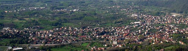
Сант-Амброджо-ди-Торино
- коммуна в Италии
Hiking in Сант-Амброджо-ди-Торино
Sant'Ambrogio di Torino, located in the Susa Valley of the Piedmont region in Italy, offers a range of scenic hiking opportunities. The area provides beautiful landscapes, diverse flora and fauna, and a taste of local culture. Here are some highlights and tips for hiking in and around Sant'Ambrogio di Torino:...
- Страна:
- Почтовый код: 10057
- Телефонный код: 011
- Код автомобильного номера: TO
- Координаты: 45° 6' 0" N, 7° 22' 0" E
- GPS треки (wikiloc): [Ссылка]
- Высота над уровнем моря: 356 м m
- Площадь: 8.37 кв.км
- Население: 4735
- Веб сайт: [Ссылка]

Альмезе
- Город в Италии, регион Пьемонт
Hiking in Альмезе
Almese is a charming town located in the Piedmont region of Italy, nestled at the foothills of the Alps. It offers a range of hiking opportunities, catering to various skill levels, from leisurely walks to more challenging trails....
- Страна:
- Почтовый код: 10040
- Телефонный код: 011
- Код автомобильного номера: TO
- Координаты: 45° 7' 0" N, 7° 24' 0" E
- GPS треки (wikiloc): [Ссылка]
- Высота над уровнем моря: 364 м m
- Площадь: 17.88 кв.км
- Население: 6409
- Веб сайт: [Ссылка]


Авильяна
- коммуна Италии
Hiking in Авильяна
Avigliana is a charming town located in the province of Turin, Italy, and it's known for its beautiful natural landscapes, particularly the Avigliana Lakes (Laghi di Avigliana) and the surrounding hills and mountains. The area offers a variety of hiking trails suitable for different skill levels, making it a great destination for outdoor enthusiasts....
- Страна:
- Почтовый код: 10051
- Телефонный код: 011
- Код автомобильного номера: TO
- Координаты: 45° 4' 46" N, 7° 23' 46" E
- GPS треки (wikiloc): [Ссылка]
- Высота над уровнем моря: 383 м m
- Площадь: 23.22 кв.км
- Население: 12443
- Веб сайт: [Ссылка]


Каприе
- коммуна Италии
Hiking in Каприе
Caprie is a charming town located in the Piedmont region of Italy, surrounded by beautiful landscapes and offers various hiking opportunities for outdoor enthusiasts. While it may not be as popular as some other hiking destinations in Italy, it provides a unique experience characterized by its scenic routes, cultural heritage, and relatively less crowded trails....
- Страна:
- Почтовый код: 10040
- Телефонный код: 011
- Код автомобильного номера: TO
- Координаты: 45° 7' 0" N, 7° 19' 0" E
- GPS треки (wikiloc): [Ссылка]
- Высота над уровнем моря: 375 м m
- Площадь: 16.41 кв.км
- Население: 2087
- Веб сайт: [Ссылка]