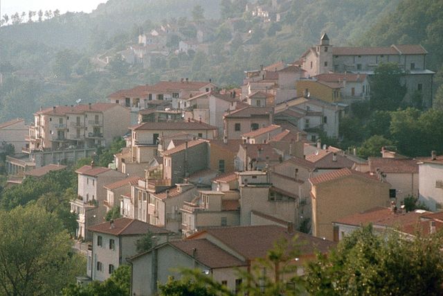
Сант'Элия-Фьюмерапидо (Sant'Elia Fiumerapido, Sant'Elia Fiumerapido)
.svg)
- коммуна Италии
 Hiking in Сант'Элия-Фьюмерапидо
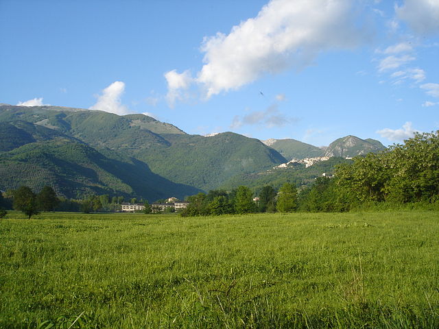
Sant'Elia Fiumerapido, a small town in the province of Frosinone in Italy, offers scenic hiking opportunities, enriched by its picturesque landscapes and proximity to natural attractions. Here are some things to consider while hiking in this area:
Trails and Natural Beauty
-
Parco Regionale dei Monti Aurunci: This regional park, located nearby, features numerous trails that provide stunning views of the mountains and valleys. Paths range from easy promenades to challenging hikes, accommodating different skill levels.
-
Forests and Wildlife: The area is home to diverse flora and fauna. Hiking here allows you to encounter various plant species, birds, and possibly some local wildlife. Be sure to carry binoculars for birdwatching!
-
Historical Sites: Some trails may lead you to ruins or historical sites, allowing you to enjoy both nature and culture during your hike.
Trail Etiquette and Safety
- Stay on Designated Trails: This helps preserve the environment and avoid damaging local ecosystems.
- Weather Awareness: Always check the weather forecast before heading out. Conditions can change quickly in mountainous areas.
- Pack Essentials: Bring plenty of water, snacks, a map, a first-aid kit, and appropriate gear for your trek, including sturdy footwear and clothing that can adapt to changing weather.
Local Recommendations
- Guided Tours: Consider joining a local hiking group or guided tour to get the most out of your experience, especially if you're unfamiliar with the area.
- Cultural Experience: After your hike, try local cuisine in Sant'Elia Fiumerapido. Engaging with the community and tasting traditional dishes like pasta and local cheeses can enhance your overall experience.
Conclusion
Hiking in Sant'Elia Fiumerapido provides an opportunity to immerse yourself in nature while enjoying the cultural richness of the region. Always prioritize safety and be respectful of the environment to ensure a rewarding experience. Happy hiking!
- Страна:

- Почтовый код: 03049
- Телефонный код: 0776
- Код автомобильного номера: FR
- Координаты: 41° 33' 0" N, 13° 52' 0" E


- GPS треки (wikiloc): [Ссылка]
- Высота над уровнем моря: 120 м m
- Площадь: 41.1 кв.км
- Население: 6048
- Веб сайт: http://www.comune.santeliafiumerapido.fr.it/
- Википедия русская: wiki(ru)
- Википедия английская: wiki(en)
- Википедия национальная: wiki(it)
- Хранилище Wikidata: Wikidata: Q117333
- Катеория в википедии: [Ссылка]
- код Freebase: [/m/0f5sjx]
- код GeoNames: Альт: [6540540]
- код VIAF: Альт: [157460071]
- ID отношения в OpenStreetMap: [41342]
- код ISTAT: 060068
- кадастровый код Италии: I321
Граничит с регионами:
Бельмонте-Кастелло
- коммуна Италии
Hiking in Бельмонте-Кастелло
Belmonte Castello is a charming municipality in Italy, situated within the province of Frosinone in the Lazio region. It offers a variety of hiking opportunities thanks to its picturesque landscapes, hilly terrain, and rich historical context....
- Страна:
- Почтовый код: 03040
- Телефонный код: 0776
- Код автомобильного номера: FR
- Координаты: 41° 35' 0" N, 13° 49' 0" E
- GPS треки (wikiloc): [Ссылка]
- Высота над уровнем моря: 369 м m
- Площадь: 14.05 кв.км
- Население: 708
- Веб сайт: [Ссылка]


Кассино
- коммуна Италии
Hiking in Кассино
Cassino, located in the Lazio region of Italy, is known for its rich history and beautiful landscapes. It offers a variety of hiking opportunities that cater to different skill levels, making it an ideal destination for both casual walkers and experienced hikers. Here are some highlights and tips for hiking in the Cassino area:...
- Страна:
- Почтовый код: 03043
- Телефонный код: 0776
- Код автомобильного номера: FR
- Координаты: 41° 29' 30" N, 13° 50' 0" E
- GPS треки (wikiloc): [Ссылка]
- Высота над уровнем моря: 40 м m
- Площадь: 83.42 кв.км
- Население: 36497
- Веб сайт: [Ссылка]
Черваро
- коммуна Италии
Hiking in Черваро
Cervaro is a charming town located in the province of Frosinone in Italy, nestled within the picturesque landscapes of the Lazio region. While it is not as well-known as some other hiking destinations in Italy, it offers a variety of opportunities for outdoor enthusiasts, particularly those who enjoy trekking and exploring the natural beauty of the area....
- Страна:
- Почтовый код: 03044
- Телефонный код: 0776
- Код автомобильного номера: FR
- Координаты: 41° 28' 58" N, 13° 54' 8" E
- GPS треки (wikiloc): [Ссылка]
- Высота над уровнем моря: 250 м m
- Площадь: 39.41 кв.км
- Население: 8093
- Веб сайт: [Ссылка]

Пичиниско
- коммуна Италии
Hiking in Пичиниско
Picinisco is a charming village located in the province of Frosinone, in the Lazio region of Italy. Nestled in the Apennine mountains, it offers a variety of hiking opportunities that allow visitors to explore its stunning natural landscapes, rich biodiversity, and historical sites....
- Страна:
- Почтовый код: 03040
- Телефонный код: 0776
- Код автомобильного номера: FR
- Координаты: 41° 39' 0" N, 13° 52' 0" E
- GPS треки (wikiloc): [Ссылка]
- Высота над уровнем моря: 725 м m
- Площадь: 62.15 кв.км
- Население: 1173
- Веб сайт: [Ссылка]

Сан-Бьяджо-Сарачиниско
- коммуна Италии
Hiking in Сан-Бьяджо-Сарачиниско
San Biagio Saracinisco is a picturesque town located in the province of Frosinone, in the Lazio region of Italy. Nestled in the foothills of the Apennines, it offers a range of hiking opportunities that take advantage of its stunning natural landscapes, rich history, and diverse flora and fauna....
- Страна:
- Почтовый код: 03040
- Телефонный код: 0776
- Код автомобильного номера: FR
- Координаты: 41° 37' 0" N, 13° 56' 0" E
- GPS треки (wikiloc): [Ссылка]
- Высота над уровнем моря: 836 м m
- Площадь: 31.21 кв.км
- Население: 332
- Веб сайт: [Ссылка]
Терелле
- коммуна Италии
Hiking in Терелле
Terelle, a charming village located in the beautiful region of Lazio, Italy, is surrounded by stunning natural landscapes, making it an excellent destination for hiking enthusiasts. The area is characterized by rolling hills, lush forests, and breathtaking views, ideal for both novice and experienced hikers....
- Страна:
- Почтовый код: 03040
- Телефонный код: 0776
- Код автомобильного номера: FR
- Координаты: 41° 33' 0" N, 13° 47' 0" E
- GPS треки (wikiloc): [Ссылка]
- Высота над уровнем моря: 905 м m
- Площадь: 31.65 кв.км
- Население: 376
- Веб сайт: [Ссылка]
Валлеротонда
- коммуна Италии
Hiking in Валлеротонда
Vallerotonda is a charming village located in the Italian region of Lazio, within the province of Frosinone. Nestled in the scenic landscapes of the Aurunci Mountains, it's a great destination for hiking enthusiasts looking for both natural beauty and cultural experiences....
- Страна:
- Почтовый код: 03040
- Телефонный код: 0776
- Код автомобильного номера: FR
- Координаты: 41° 33' 0" N, 13° 55' 0" E
- GPS треки (wikiloc): [Ссылка]
- Высота над уровнем моря: 620 м m
- Площадь: 59.66 кв.км
- Население: 1532
- Веб сайт: [Ссылка]
Вилла-Латина
- коммуна Италии
Hiking in Вилла-Латина
Villa Latina is a charming location in the Italian region of Lazio, known for its beautiful landscapes and outdoor activities, including hiking. Nestled in the Monti Aurunci National Park, the area offers a variety of trails that cater to different skill levels, making it an excellent destination for both novice and experienced hikers....
- Страна:
- Почтовый код: 03040
- Телефонный код: 0776
- Код автомобильного номера: FR
- Координаты: 41° 37' 0" N, 13° 50' 0" E
- GPS треки (wikiloc): [Ссылка]
- Высота над уровнем моря: 415 м m
- Площадь: 17.02 кв.км
- Население: 1217