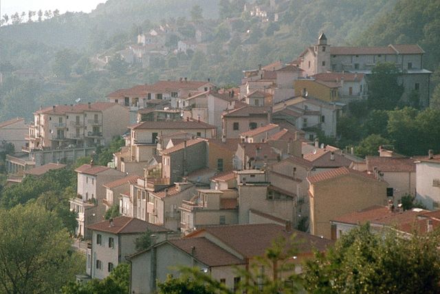
Валлеротонда (Vallerotonda, Vallerotonda)
.svg)
- коммуна Италии
 Hiking in Валлеротонда
Vallerotonda is a charming village located in the Italian region of Lazio, within the province of Frosinone. Nestled in the scenic landscapes of the Aurunci Mountains, it's a great destination for hiking enthusiasts looking for both natural beauty and cultural experiences.
Hiking Trails
-
Monte Altino: This area offers several trails that lead you through lush forests and up to Monte Altino, where you can enjoy panoramic views of the surrounding valleys and mountains.
-
Ciciano Nature Reserve: Just a short distance from Vallerotonda, this reserve features varied terrain, including rocky paths and wooded areas, ideal for day hikes. The reserve also harbors a diverse range of flora and fauna.
-
Historical Trails: Some paths take you through historical sites and remnants of ancient Roman architecture, blending hiking with cultural exploration. These trails often lead to ancient ruins, offering a glimpse into the region's history.
Best Time to Hike
The best times for hiking around Vallerotonda are during the spring (April to June) and autumn (September to October) when temperatures are mild, and the landscapes are particularly beautiful with blooming flowers or colorful fall foliage.
Preparation Tips
- Footwear: Good hiking boots are essential, as some trails can be rocky or steep.
- Water and Snacks: Always carry enough water and some snacks, especially if tackling longer trails.
- Navigation: Familiarize yourself with a map or GPS, as some trails may not be well marked.
- Weather Check: Always check the weather forecast before heading out, as conditions can change rapidly in mountainous areas.
Local Culture
Vallerotonda is also known for its local cuisine and traditions. After a hike, you might enjoy local dishes in the village, including hearty pasta and meat dishes, alongside the chance to engage with local customs.
Conclusion
Hiking in Vallerotonda offers a unique combination of natural beauty, diverse trails, and cultural richness. Whether you're an experienced hiker or a beginner, you'll find numerous opportunities to explore and enjoy the picturesque surroundings of this tranquil village in Italy.
- Страна:

- Почтовый код: 03040
- Телефонный код: 0776
- Код автомобильного номера: FR
- Координаты: 41° 33' 0" N, 13° 55' 0" E


- GPS треки (wikiloc): [Ссылка]
- Высота над уровнем моря: 620 м m
- Площадь: 59.66 кв.км
- Население: 1532
- Веб сайт: http://www.vallerotonda.net
- Википедия русская: wiki(ru)
- Википедия английская: wiki(en)
- Википедия национальная: wiki(it)
- Хранилище Wikidata: Wikidata: Q117518
- Катеория в википедии: [Ссылка]
- код Freebase: [/m/06kfh0]
- код GeoNames: Альт: [6538717]
- код VIAF: Альт: [128178352]
- ID отношения в OpenStreetMap: [41344]
- код ISTAT: 060084
- кадастровый код Италии: L614
Граничит с регионами:
Аккуафондата
- коммуна Италии
Hiking in Аккуафондата
Acquafondata is a charming village located in the province of Frosinone, in the Lazio region of Italy. The area is nestled within the stunning Apennine Mountains, making it a great location for hiking enthusiasts. Here are some highlights and tips for hiking in Acquafondata:...
- Страна:
- Почтовый код: 03040
- Телефонный код: 0776
- Код автомобильного номера: FR
- Координаты: 41° 33' 0" N, 13° 57' 0" E
- GPS треки (wikiloc): [Ссылка]
- Высота над уровнем моря: 946 м m
- Площадь: 25.32 кв.км
- Население: 267
- Веб сайт: [Ссылка]
Черваро
- коммуна Италии
Hiking in Черваро
Cervaro is a charming town located in the province of Frosinone in Italy, nestled within the picturesque landscapes of the Lazio region. While it is not as well-known as some other hiking destinations in Italy, it offers a variety of opportunities for outdoor enthusiasts, particularly those who enjoy trekking and exploring the natural beauty of the area....
- Страна:
- Почтовый код: 03044
- Телефонный код: 0776
- Код автомобильного номера: FR
- Координаты: 41° 28' 58" N, 13° 54' 8" E
- GPS треки (wikiloc): [Ссылка]
- Высота над уровнем моря: 250 м m
- Площадь: 39.41 кв.км
- Население: 8093
- Веб сайт: [Ссылка]

Сан-Бьяджо-Сарачиниско
- коммуна Италии
Hiking in Сан-Бьяджо-Сарачиниско
San Biagio Saracinisco is a picturesque town located in the province of Frosinone, in the Lazio region of Italy. Nestled in the foothills of the Apennines, it offers a range of hiking opportunities that take advantage of its stunning natural landscapes, rich history, and diverse flora and fauna....
- Страна:
- Почтовый код: 03040
- Телефонный код: 0776
- Код автомобильного номера: FR
- Координаты: 41° 37' 0" N, 13° 56' 0" E
- GPS треки (wikiloc): [Ссылка]
- Высота над уровнем моря: 836 м m
- Площадь: 31.21 кв.км
- Население: 332
- Веб сайт: [Ссылка]


Сант'Элия-Фьюмерапидо
- коммуна Италии
Hiking in Сант'Элия-Фьюмерапидо
Sant'Elia Fiumerapido, a small town in the province of Frosinone in Italy, offers scenic hiking opportunities, enriched by its picturesque landscapes and proximity to natural attractions. Here are some things to consider while hiking in this area:...
- Страна:
- Почтовый код: 03049
- Телефонный код: 0776
- Код автомобильного номера: FR
- Координаты: 41° 33' 0" N, 13° 52' 0" E
- GPS треки (wikiloc): [Ссылка]
- Высота над уровнем моря: 120 м m
- Площадь: 41.1 кв.км
- Население: 6048
- Веб сайт: [Ссылка]


Витикузо
- коммуна Италии
Hiking in Витикузо
Viticuso is a charming village located in the province of Frosinone, in the Lazio region of Italy. Nestled within the beautiful landscape of the Apennine Mountains, it offers various hiking opportunities for enthusiasts of all levels....
- Страна:
- Почтовый код: 03040
- Телефонный код: 0776
- Код автомобильного номера: FR
- Координаты: 41° 32' 0" N, 13° 58' 0" E
- GPS треки (wikiloc): [Ссылка]
- Высота над уровнем моря: 825 м m
- Площадь: 20.86 кв.км
- Население: 324
- Веб сайт: [Ссылка]
Филиньяно
- коммуна Италии
Hiking in Филиньяно
Filignano is a charming hilltop village located in the Molise region of Italy, surrounded by beautiful landscapes and rich in natural beauty, making it a great destination for hiking enthusiasts. Here are some highlights and tips about hiking in and around Filignano:...
- Страна:
- Почтовый код: 86074
- Телефонный код: 0865
- Код автомобильного номера: IS
- Координаты: 41° 33' 0" N, 14° 3' 0" E
- GPS треки (wikiloc): [Ссылка]
- Высота над уровнем моря: 460 м m
- Площадь: 30.88 кв.км
- Население: 636
- Веб сайт: [Ссылка]


Роккетта-а-Вольтурно
- коммуна Италии
Hiking in Роккетта-а-Вольтурно
Rocchetta a Volturno is a picturesque village located in the region of Molise in Italy, surrounded by the scenic landscapes of the Apennine Mountains. The area offers a variety of hiking opportunities for both beginners and experienced hikers, with trails that showcase its natural beauty, historical sites, and local wildlife....
- Страна:
- Почтовый код: 86070
- Телефонный код: 0865
- Код автомобильного номера: IS
- Координаты: 41° 37' 0" N, 14° 5' 0" E
- GPS треки (wikiloc): [Ссылка]
- Высота над уровнем моря: 540 м m
- Площадь: 23.34 кв.км
- Население: 1096
- Веб сайт: [Ссылка]