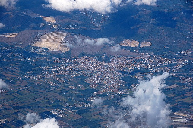
Санта-Мария-а-Вико (Santa Maria a Vico, Santa Maria a Vico)
.svg)
- коммуна Италии
 Hiking in Санта-Мария-а-Вико
Santa Maria a Vico is a small town located in the Campania region of Italy, not far from Naples. While it may not be as widely recognized as some of the more famous hiking destinations in Italy, it offers some charming and scenic trails for those looking to explore the natural beauty of the area.
Hiking Opportunities
-
Local Trails: The surrounding countryside features various paths that lead through lush landscapes and rustic villages. These trails are often less crowded than those found in more touristy areas, providing a quiet and immersive experience.
-
Monte Taburno: Not too far from Santa Maria a Vico is the Monte Taburno, part of the Taburno-Camposauro Regional Park. It offers a variety of hiking trails with different difficulty levels, allowing hikers to enjoy stunning views of the region, including the surrounding valleys and distant mountains.
-
Vineyard Trails: The area is known for its vineyards and agricultural land. Some hiking routes might take you through these scenic landscapes, where you can also experience local wine culture.
Hints and Tips
-
Weather Considerations: Check the weather before you go, as conditions can change quickly in mountainous areas. Spring and fall are generally the best times to hike.
-
Local Guidance: If you're unfamiliar with the area, consider reaching out to local hiking groups or guides, as they can provide useful insights and ensure you explore safely.
-
Safety Essentials: Always bring water, snacks, a first-aid kit, and wear appropriate footwear. It's also wise to have a map or a GPS device as some trails might not be well-marked.
Conclusion
Hiking in and around Santa Maria a Vico can be a rewarding experience, especially for those looking to explore lesser-known paths rich in natural beauty and cultural charm. Whether you are a seasoned hiker or a casual walker, the area has something to offer for everyone looking to enjoy the outdoors.
- Страна:

- Почтовый код: 81028
- Телефонный код: 0823
- Код автомобильного номера: CE
- Координаты: 41° 2' 0" N, 14° 29' 0" E


- GPS треки (wikiloc): [Ссылка]
- Высота над уровнем моря: 83 м m
- Площадь: 10.84 кв.км
- Население: 14004
- Веб сайт: http://www.comunesantamariaavico.it/
- Википедия русская: wiki(ru)
- Википедия английская: wiki(en)
- Википедия национальная: wiki(it)
- Хранилище Wikidata: Wikidata: Q58895
- Катеория в википедии: [Ссылка]
- код Freebase: [/m/0gm_p5]
- код GeoNames: Альт: [6541677]
- код VIAF: Альт: [246298564]
- ID отношения в OpenStreetMap: [41033]
- место в MusicBrainz: [9a2be547-415f-48fa-b3b1-8eea9bf44bf9]
- код Цифрового атласа Римской империи: [22187]
- код ISTAT: 061082
- кадастровый код Италии: I233
Граничит с регионами:


Дураццано
- коммуна Италии
Hiking in Дураццано
Durazzano is a charming town located in the Campania region of Italy, nestled between the mountains and the valleys, making it a picturesque destination for hiking enthusiasts. Here are some aspects to consider when hiking in and around Durazzano:...
- Страна:
- Почтовый код: 82015
- Телефонный код: 0823
- Код автомобильного номера: BN
- Координаты: 41° 3' 46" N, 14° 26' 58" E
- GPS треки (wikiloc): [Ссылка]
- Высота над уровнем моря: 286 м m
- Площадь: 12.91 кв.км
- Население: 2201
- Веб сайт: [Ссылка]


Сант'Агата-де'-Готи
- коммуна Италии
Hiking in Сант'Агата-де'-Готи
Sant'Agata de' Goti is a picturesque town located in the Campania region of Italy, known for its medieval architecture and stunning natural surroundings. Hiking in this area offers a unique combination of historical exploration and beautiful landscapes. Here are some aspects to consider:...
- Страна:
- Почтовый код: 82019
- Телефонный код: 0823
- Код автомобильного номера: BN
- Координаты: 41° 5' 22" N, 14° 29' 51" E
- GPS треки (wikiloc): [Ссылка]
- Высота над уровнем моря: 156 м m
- Площадь: 63.38 кв.км
- Население: 11151
- Веб сайт: [Ссылка]
Ариенцо
- коммуна Италии
Hiking in Ариенцо
Arienzo is a small village located on the Amalfi Coast in Italy, known for its picturesque landscapes, beautiful hiking trails, and stunning views of the Mediterranean Sea. Hiking in and around Arienzo offers a variety of experiences, from leisurely walks to more challenging treks....
- Страна:
- Почтовый код: 81021
- Телефонный код: 0823
- Код автомобильного номера: CE
- Координаты: 41° 1' 38" N, 14° 29' 52" E
- GPS треки (wikiloc): [Ссылка]
- Высота над уровнем моря: 70 м m
- Площадь: 14.01 кв.км
- Население: 5374
- Веб сайт: [Ссылка]

Червино
- коммуна Италии
Hiking in Червино
Cervino is a charming village situated in the Province of Campania, Italy. The surrounding areas offer a variety of hiking opportunities that showcase the region's beautiful landscapes, rich biodiversity, and historical sites. Here are some key points to consider if you're thinking about hiking in and around Cervino:...
- Страна:
- Почтовый код: 81023
- Телефонный код: 0823
- Код автомобильного номера: CE
- Координаты: 41° 3' 0" N, 14° 25' 0" E
- GPS треки (wikiloc): [Ссылка]
- Высота над уровнем моря: 140 м m
- Площадь: 8.21 кв.км
- Население: 5011
- Веб сайт: [Ссылка]
Маддалони
- коммуна Италии
Hiking in Маддалони
Maddaloni is a town in the Campania region of southern Italy, located near the city of Caserta. While Maddaloni itself is primarily known for its historical significance and beautiful architecture, the surrounding area offers some excellent hiking opportunities, particularly in the nearby Matese Regional Park and the broader Campania landscape....
- Страна:
- Почтовый код: 81024
- Телефонный код: 0823
- Код автомобильного номера: CE
- Координаты: 41° 2' 0" N, 14° 23' 0" E
- GPS треки (wikiloc): [Ссылка]
- Высота над уровнем моря: 73 м m
- Площадь: 36.67 кв.км
- Население: 39026
- Веб сайт: [Ссылка]
Сан-Феличе-а-Канчелло
- коммуна Италии
Hiking in Сан-Феличе-а-Канчелло
San Felice a Cancello, located in the province of Caserta in Italy, is surrounded by picturesque landscapes that offer several opportunities for hiking enthusiasts. The area features beautiful countryside, rolling hills, and a mix of nature and historical sites that make it appealing for outdoor activities....
- Страна:
- Почтовый код: 81027
- Телефонный код: 081; 0823
- Код автомобильного номера: CE
- Координаты: 40° 59' 36" N, 14° 25' 15" E
- GPS треки (wikiloc): [Ссылка]
- Высота над уровнем моря: 89 м m
- Площадь: 27.18 кв.км
- Население: 17462
- Веб сайт: [Ссылка]