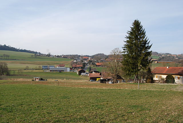
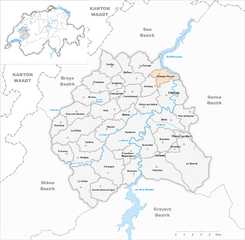
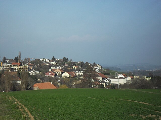
Сарин (Sarine District, Saanebezirk)

- округ в Швейцарии
 Hiking in Сарин
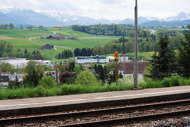
The Sarine District, located in the canton of Fribourg in Switzerland, offers a variety of hiking opportunities that cater to different levels of experience and preferences. Here’s an overview of what you can expect when hiking in this picturesque region:
Scenic Trails
- Diverse Landscapes: The district features rolling hills, lush green valleys, and stunning views of the Swiss Alps. Trails often lead hikers through forests, farmland, and along rivers, providing a rich tapestry of landscapes.
- Historical Sites: As you hike, you may encounter charming villages, historical sites, and cultural landmarks, making for an enriching experience that combines nature and history.
Popular Hiking Routes
- La Gruyère Regional Nature Park: This area is renowned for its picturesque trails that pass through the famous Gruyère region, known for cheese production. You can enjoy views of the mountains and traverse charming villages along the way.
- Moleson Mountain: Trails leading to Moleson offer breathtaking panoramic views. The ascent varies in difficulty, making it accessible for hikers with different skill levels.
- The Fribourg Pre-Alps: Contains several marked hiking paths with varying lengths and difficulties, perfect for day hikes or longer excursions. The terrain is suitable for both novice and experienced hikers.
Hiking Tips
- Seasonal Considerations: Summer and early autumn offer the best conditions for hiking. In winter, some trails may become challenging due to snow and ice, so proper gear is essential.
- Trail Maps and Markings: Ensure you have a good map or a hiking app to navigate the trails. Most hiking paths are well-marked, but it's always good to stay informed about your route.
- Local Weather: The weather can change quickly in the Alps, so check forecasts before heading out and be prepared for varying conditions.
Accessibility
- Many trails are accessible from major towns like Fribourg, Bulle, and the surrounding villages, facilitating easy travel to starting points. Public transport is often available to help reach more remote trailheads.
Safety Considerations
- Always inform someone about your hike plans, especially if you're venturing into less populated areas.
- Carry enough water, snacks, and a first-aid kit.
- Pay attention to your physical limits and the difficulty levels of trails.
Whether you’re looking for a leisurely walk or a challenging trek, the Sarine District has something to offer every hiker. Enjoy your adventure and take in the stunning natural beauty of this Swiss region!
- Страна:

- Столица: Фрибур
- Код автомобильного номера: FR
- Координаты: 46° 47' 4" N, 7° 6' 0" E


- GPS треки (wikiloc): [Ссылка]
- Высота над уровнем моря: 591 м m
- Площадь: 217.60 кв.км
- Веб сайт: http://www.fr.ch/pref/fr/pub/psa/index.cfm
- Википедия английская: wiki(en)
- Википедия национальная: wiki(de)
- Хранилище Wikidata: Wikidata: Q660688
- Катеория в википедии: [Ссылка]
- код Freebase: [/m/026wv61]
- код GeoNames: Альт: [6458767]
- ID отношения в OpenStreetMap: [1698884]
- идентификатор HDS: [8154]
Включает регионы:

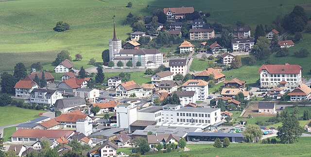
La Sonnaz
Hiking in La Sonnaz
La Sonnaz is a beautiful region in the Swiss Alps, often celebrated for its stunning scenery, diverse trails, and the opportunity to connect deeply with nature. If you're considering hiking in this area, here are some key points to keep in mind:...
- Страна:
- Почтовый код: 1782
- Телефонный код: 026
- Код автомобильного номера: FR
- Координаты: 46° 50' 2" N, 7° 6' 31" E
- GPS треки (wikiloc): [Ссылка]
- Высота над уровнем моря: 575 м m
- Площадь: 6.9 кв.км
- Население: 1129
- Веб сайт: [Ссылка]


Фрибур
- столица кантона Фрибур в Швейцарии
Hiking in Фрибур
Fribourg, located in the heart of Switzerland, is a beautiful region filled with picturesque landscapes, charming villages, and a variety of hiking trails suitable for all levels of hikers. Here are some key points to consider when hiking in Fribourg:...
- Страна:
- Почтовый код: 1700–1709
- Телефонный код: 026
- Код автомобильного номера: FR
- Координаты: 46° 48' 0" N, 7° 9' 0" E
- GPS треки (wikiloc): [Ссылка]
- Высота над уровнем моря: 587 м m
- Площадь: 9.28 кв.км
- Население: 38829
- Веб сайт: [Ссылка]


Arconciel
Hiking in Arconciel
Arconciel, a picturesque village located in the Canton of Fribourg, Switzerland, offers several opportunities for hiking enthusiasts. Nestled in the rolling hills and beautiful landscapes typical of the region, it serves as a great starting point for a variety of hiking trails....
- Страна:
- Телефонный код: 026
- Код автомобильного номера: FR
- Координаты: 46° 45' 0" N, 7° 7' 0" E
- GPS треки (wikiloc): [Ссылка]
- Высота над уровнем моря: 734 м m
- Площадь: 6.11 кв.км
- Население: 916
- Веб сайт: [Ссылка]


Belfaux
Hiking in Belfaux
Belfaux, a charming village in the Fribourg canton of Switzerland, is surrounded by beautiful landscapes that make it an excellent destination for hiking enthusiasts. Here are some highlights and tips for hiking in the area:...
- Страна:
- Почтовый код: 1782
- Телефонный код: 026
- Код автомобильного номера: FR
- Координаты: 46° 49' 43" N, 7° 5' 42" E
- GPS треки (wikiloc): [Ссылка]
- Высота над уровнем моря: 640 м m
- Площадь: 6.43 кв.км
- Население: 3338
- Веб сайт: [Ссылка]


Marly
Hiking in Marly
Marly, located just outside of Fribourg, Switzerland, offers a variety of hiking opportunities that showcase the scenic beauty of the region. The area is known for its lush greenery, rolling hills, and panoramic views of the Fribourg region, making it a great destination for both casual walkers and more experienced hikers....
- Страна:
- Почтовый код: 1723
- Телефонный код: 026
- Код автомобильного номера: FR
- Координаты: 46° 47' 0" N, 7° 10' 0" E
- GPS треки (wikiloc): [Ссылка]
- Высота над уровнем моря: 627 м m
- Площадь: 7.68 кв.км
- Население: 8201
- Веб сайт: [Ссылка]

Matran
Hiking in Matran
Matran is a charming municipality located in the canton of Fribourg in Switzerland. It is surrounded by beautiful landscapes, making it an excellent spot for hiking enthusiasts. Here are some highlights to know about hiking in Matran:...
- Страна:
- Почтовый код: 1753
- Телефонный код: 026
- Код автомобильного номера: FR
- Координаты: 46° 47' 2" N, 7° 5' 28" E
- GPS треки (wikiloc): [Ссылка]
- Высота над уровнем моря: 611 м m
- Площадь: 2.89 кв.км
- Население: 1523
- Веб сайт: [Ссылка]
Ferpicloz
Hiking in Ferpicloz
Ferpicloz is a small village in the canton of Fribourg, Switzerland, nestled in a picturesque setting with beautiful landscapes. Hiking in and around Ferpicloz allows you to enjoy the stunning views of the Swiss countryside, rolling hills, and distant mountain ranges. Here are some aspects to consider when planning a hiking trip in this area:...
- Страна:
- Почтовый код: 1724
- Телефонный код: 026
- Код автомобильного номера: FR
- Координаты: 46° 44' 51" N, 7° 9' 49" E
- GPS треки (wikiloc): [Ссылка]
- Высота над уровнем моря: 785 м m
- Площадь: 1.03 кв.км
- Население: 283
- Веб сайт: [Ссылка]


Le Glèbe
Hiking in Le Glèbe
Le Glèbe, located in the province of Quebec, Canada, offers a variety of hiking opportunities set in a picturesque landscape characterized by forests, mountains, and lakes. Here are some key points to consider when planning a hike in this region:...
- Страна:
- Почтовый код: 1695
- Телефонный код: 026
- Код автомобильного номера: FR
- Координаты: 46° 43' 0" N, 7° 2' 0" E
- GPS треки (wikiloc): [Ссылка]
- Высота над уровнем моря: 756 м m
- Площадь: 10.231 кв.км
- Веб сайт: [Ссылка]
Corpataux-Magnedens
Hiking in Corpataux-Magnedens
Corpataux-Magnedens, located in Switzerland, is a lesser-known but beautiful region for hiking enthusiasts. The area boasts stunning landscapes, encompassing rolling hills, lush forests, and picturesque views of the surrounding mountains. Here are some key points to consider if you plan to hike in Corpataux-Magnedens:...
- Страна:
- Почтовый код: 1727
- Телефонный код: 026
- Код автомобильного номера: FR
- Координаты: 46° 45' 0" N, 7° 6' 0" E
- GPS треки (wikiloc): [Ссылка]
- Высота над уровнем моря: 687 м m
- Площадь: 4.47 кв.км
- Веб сайт: [Ссылка]


Givisiez
Hiking in Givisiez
Givisiez is a picturesque village located near Fribourg in Switzerland, surrounded by stunning landscapes that make it an excellent destination for hiking enthusiasts. The area boasts a variety of trails that cater to different skill levels and preferences, allowing hikers to enjoy the natural beauty of the Swiss countryside....
- Страна:
- Почтовый код: 1762
- Телефонный код: 026
- Код автомобильного номера: FR
- Координаты: 46° 49' 0" N, 7° 8' 0" E
- GPS треки (wikiloc): [Ссылка]
- Высота над уровнем моря: 629 м m
- Площадь: 3.45 кв.км
- Население: 3199
- Веб сайт: [Ссылка]


Neyruz
Hiking in Neyruz
Neyruz is a charming municipality located in the canton of Fribourg, Switzerland. Nestled between lush green landscapes and rolling hills, it offers a variety of hiking opportunities suitable for different skill levels. Here are some highlights for hiking in Neyruz:...
- Страна:
- Почтовый код: 1740
- Телефонный код: 026
- Код автомобильного номера: FR
- Координаты: 46° 46' 0" N, 7° 4' 0" E
- GPS треки (wikiloc): [Ссылка]
- Высота над уровнем моря: 692 м m
- Площадь: 5.54 кв.км
- Население: 2593
- Веб сайт: [Ссылка]


Le Mouret
Hiking in Le Mouret
Le Mouret is a charming village in Switzerland, nestled in the canton of Fribourg, surrounded by beautiful natural landscapes that are perfect for hiking enthusiasts. The region offers a variety of trails that cater to different skill levels, making it accessible for both beginners and experienced hikers....
- Страна:
- Почтовый код: 1724
- Телефонный код: 026
- Код автомобильного номера: FR
- Координаты: 46° 45' 0" N, 7° 10' 0" E
- GPS треки (wikiloc): [Ссылка]
- Высота над уровнем моря: 754 м m
- Площадь: 18.47 кв.км
- Население: 3134
- Веб сайт: [Ссылка]


Corminboeuf
Hiking in Corminboeuf
Corminboeuf is a charming municipality located in the Canton of Fribourg, Switzerland. It's surrounded by picturesque landscapes that offer various hiking opportunities for both beginners and experienced hikers. Here’s what you can expect when hiking in and around Corminboeuf:...
- Страна:
- Почтовый код: 1720
- Телефонный код: 026
- Код автомобильного номера: FR
- Координаты: 46° 48' 0" N, 7° 6' 0" E
- GPS треки (wikiloc): [Ссылка]
- Высота над уровнем моря: 633 м m
- Площадь: 5.61 кв.км
- Население: 2563
- Веб сайт: [Ссылка]


Rossens
Hiking in Rossens
Rossens, located in the canton of Fribourg, Switzerland, is a great spot for hiking enthusiasts. Nestled in a picturesque landscape, the area offers a variety of trails that cater to different skill levels, making it an excellent destination for both beginners and experienced hikers....
- Страна:
- Почтовый код: 1728
- Телефонный код: 026
- Код автомобильного номера: FR
- Координаты: 46° 43' 0" N, 7° 6' 0" E
- GPS треки (wikiloc): [Ссылка]
- Высота над уровнем моря: 708 м m
- Площадь: 5.06 кв.км
- Веб сайт: [Ссылка]


Ependes
Hiking in Ependes
Épendes, located in the Fribourg region of Switzerland, offers picturesque hiking opportunities amidst stunning landscapes. The area is characterized by rolling hills, lush forests, and charming rural scenery, making it a great place for both casual walkers and experienced hikers....
- Страна:
- Почтовый код: 1731
- Телефонный код: 026
- Код автомобильного номера: FR
- Координаты: 46° 45' 0" N, 7° 9' 0" E
- GPS треки (wikiloc): [Ссылка]
- Высота над уровнем моря: 750 м m
- Площадь: 5.63 кв.км
- Население: 1111
- Веб сайт: [Ссылка]


Farvagny
Hiking in Farvagny
Farvagny, situated in the district of Fribourg, Switzerland, is a quaint village that offers a charming setting for hiking enthusiasts. The region is surrounded by stunning landscapes, rolling hills, and picturesque farmlands that make for scenic trekking experiences....
- Страна:
- Почтовый код: 1726
- Телефонный код: 026
- Код автомобильного номера: FR
- Координаты: 46° 43' 0" N, 7° 4' 0" E
- GPS треки (wikiloc): [Ссылка]
- Высота над уровнем моря: 700 м m
- Площадь: 10.03 кв.км
- Веб сайт: [Ссылка]


La Brillaz
Hiking in La Brillaz
La Brillaz is a picturesque area located in the Alps, often favored for its stunning mountain views, diverse flora and fauna, and numerous hiking trails. Depending on the specific region and season, here are some general tips and highlights for hiking in La Brillaz:...
- Страна:
- Почтовый код: 1745, 1756
- Телефонный код: 026
- Код автомобильного номера: FR
- Координаты: 46° 46' 0" N, 7° 0' 0" E
- GPS треки (wikiloc): [Ссылка]
- Высота над уровнем моря: 720 м m
- Площадь: 10.26 кв.км
- Население: 2028
- Веб сайт: [Ссылка]


Grolley
Hiking in Grolley
Grolley, located in the canton of Fribourg in Switzerland, offers a variety of scenic hiking opportunities suitable for different skill levels. The region is characterized by beautiful landscapes, rolling hills, and a mix of forests and agricultural land....
- Страна:
- Почтовый код: 1772
- Телефонный код: 026
- Код автомобильного номера: FR
- Координаты: 46° 50' 0" N, 7° 4' 0" E
- GPS треки (wikiloc): [Ссылка]
- Высота над уровнем моря: 625 м m
- Площадь: 5.32 кв.км
- Население: 1947
- Веб сайт: [Ссылка]

Granges-Paccot
Hiking in Granges-Paccot
Granges-Paccot, located in the canton of Fribourg in Switzerland, is an area offering beautiful landscapes suitable for hiking enthusiasts. While it may not be as well-known as some of the more iconic Swiss hiking destinations, it boasts charming trails that are ideal for both leisurely walks and more challenging hikes....
- Страна:
- Почтовый код: 1763
- Телефонный код: 026
- Код автомобильного номера: FR
- Координаты: 46° 49' 0" N, 7° 9' 0" E
- GPS треки (wikiloc): [Ссылка]
- Высота над уровнем моря: 620 м m
- Площадь: 3.98 кв.км
- Население: 3686
- Веб сайт: [Ссылка]


Avry
Hiking in Avry
Hiking in Avry, a region located near Fribourg in Switzerland, offers a fantastic blend of stunning landscapes, well-marked trails, and a rich cultural experience. The area is known for its picturesque scenery, including rolling hills, lush forests, and views of the surrounding Alps. Here are some highlights to consider when planning a hike in Avry:...
- Страна:
- Телефонный код: 026
- Код автомобильного номера: FR
- Координаты: 46° 47' 0" N, 7° 4' 0" E
- GPS треки (wikiloc): [Ссылка]
- Высота над уровнем моря: 679 м m
- Площадь: 5.81 кв.км
- Население: 1880
- Веб сайт: [Ссылка]


Chénens
Hiking in Chénens
Chénens, a charming farm village located in the canton of Fribourg, Switzerland, offers a unique hiking experience that combines beautiful landscapes with serene rural settings. While it may not be among the most famous hiking destinations, the surrounding region is packed with trails that cater to various skill levels and preferences....
- Страна:
- Почтовый код: 1744
- Телефонный код: 026
- Код автомобильного номера: FR
- Координаты: 46° 44' 0" N, 7° 0' 0" E
- GPS треки (wikiloc): [Ссылка]
- Высота над уровнем моря: 696 м m
- Площадь: 3.94 кв.км
- Население: 858
- Веб сайт: [Ссылка]


Hauterive
Hiking in Hauterive
Hauterive is a charming village located near the city of Fribourg in Switzerland, and it offers some delightful hiking opportunities. The region is characterized by its picturesque landscapes, rolling hills, and views of the Sarine River, which make for a rewarding hiking experience. Here are some key points to consider when planning a hike in and around Hauterive:...
- Страна:
- Почтовый код: 1725, 1730
- Телефонный код: 026
- Код автомобильного номера: FR
- Координаты: 46° 46' 0" N, 7° 7' 0" E
- GPS треки (wikiloc): [Ссылка]
- Высота над уровнем моря: 680 м m
- Площадь: 11.92 кв.км
- Население: 2513
- Веб сайт: [Ссылка]


Pierrafortscha
Hiking in Pierrafortscha
Pierrafortscha is a beautiful mountain located in the Swiss Alps, primarily known for its stunning landscapes and hiking opportunities. While specific trails may vary, here’s a general overview of what you can expect when hiking in this region....
- Страна:
- Почтовый код: 1723
- Телефонный код: 026
- Код автомобильного номера: FR
- Координаты: 46° 47' 0" N, 7° 11' 0" E
- GPS треки (wikiloc): [Ссылка]
- Высота над уровнем моря: 751 м m
- Площадь: 5.06 кв.км
- Население: 154
- Веб сайт: [Ссылка]


Villarsel-sur-Marly
Hiking in Villarsel-sur-Marly
Villarsel-sur-Marly, located in the Canton of Fribourg in Switzerland, offers a serene hiking experience with picturesque landscapes and charming rural settings. Here are some key points to consider for hiking in this area:...
- Страна:
- Почтовый код: 1723
- Телефонный код: 026
- Код автомобильного номера: FR
- Координаты: 46° 46' 0" N, 7° 10' 0" E
- GPS треки (wikiloc): [Ссылка]
- Высота над уровнем моря: 736 м m
- Площадь: 1.43 кв.км
- Население: 85
- Веб сайт: [Ссылка]


Ponthaux
Hiking in Ponthaux
Ponthaux is a picturesque area located in the French Alps, known for its stunning landscapes, beautiful trails, and diverse wildlife. Hiking in and around Ponthaux offers a range of experiences suitable for all levels of hikers, from beginners to experienced mountaineers....
- Страна:
- Почтовый код: 1772
- Телефонный код: 026
- Код автомобильного номера: FR
- Координаты: 46° 49' 0" N, 7° 2' 0" E
- GPS треки (wikiloc): [Ссылка]
- Высота над уровнем моря: 650 м m
- Площадь: 5.91 кв.км
- Население: 727
- Веб сайт: [Ссылка]


Autafond
Hiking in Autafond
It seems there might be a misunderstanding, as "Autafond" doesn't appear to be a recognized hiking destination or location in my current training data up to October 2023....
- Страна:
- Телефонный код: 026
- Код автомобильного номера: FR
- Координаты: 46° 49' 0" N, 7° 5' 0" E
- GPS треки (wikiloc): [Ссылка]
- Высота над уровнем моря: 694 м m
- Веб сайт: [Ссылка]


Prez-vers-Noréaz
Hiking in Prez-vers-Noréaz
Prez-vers-Noréaz is a picturesque village located in the canton of Fribourg, Switzerland. It’s nestled in a region known for its charming landscapes, including rolling hills, lush forests, and stunning views of the surrounding mountains. Hiking in and around Prez-vers-Noréaz offers a delightful experience for those who appreciate nature and the great outdoors....
- Страна:
- Почтовый код: 1746
- Телефонный код: 026
- Код автомобильного номера: FR
- Координаты: 46° 47' 0" N, 7° 1' 0" E
- GPS треки (wikiloc): [Ссылка]
- Высота над уровнем моря: 646 м m
- Площадь: 5.7 кв.км
- Население: 1109
- Веб сайт: [Ссылка]


Noréaz
Hiking in Noréaz
Noréaz, located in the canton of Fribourg in Switzerland, offers a variety of hiking opportunities that showcase the picturesque Swiss countryside and stunning views of the surrounding landscape. Here are some key points about hiking in Noréaz:...
- Страна:
- Почтовый код: 1757
- Телефонный код: 026
- Код автомобильного номера: FR
- Координаты: 46° 48' 0" N, 7° 2' 0" E
- GPS треки (wikiloc): [Ссылка]
- Высота над уровнем моря: 638 м m
- Площадь: 6.91 кв.км
- Население: 695
- Веб сайт: [Ссылка]
Senèdes
Hiking in Senèdes
Senèdes, a charming locale in Switzerland, offers beautiful hiking opportunities with a blend of scenic landscapes and engaging trails. The area features rolling hills, lush forests, and panoramic views of surrounding mountains and valleys....
- Страна:
- Почтовый код: 1724
- Телефонный код: 026
- Код автомобильного номера: FR
- Координаты: 46° 45' 0" N, 7° 9' 0" E
- GPS треки (wikiloc): [Ссылка]
- Высота над уровнем моря: 748 м m
- Площадь: 0.50 кв.км
- Население: 158
- Веб сайт: [Ссылка]


Vuisternens-en-Ogoz
Hiking in Vuisternens-en-Ogoz
Vuisternens-en-Ogoz is a picturesque area located in the Canton of Fribourg, Switzerland. Known for its natural beauty and serene landscape, it's a great destination for hiking enthusiasts. Here are some highlights and tips for hiking in this area:...
- Страна:
- Почтовый код: 1696
- Телефонный код: 026
- Код автомобильного номера: FR
- Координаты: 46° 42' 0" N, 7° 3' 0" E
- GPS треки (wikiloc): [Ссылка]
- Высота над уровнем моря: 800 м m
- Площадь: 6.24 кв.км
- Веб сайт: [Ссылка]

Treyvaux
Hiking in Treyvaux
Treyvaux is a charming village located in the canton of Fribourg, Switzerland, and is surrounded by stunning landscapes that are great for hiking enthusiasts. Here are some highlights of hiking in the Treyvaux area:...
- Страна:
- Почтовый код: 1733
- Телефонный код: 026
- Код автомобильного номера: FR
- Координаты: 46° 44' 0" N, 7° 8' 0" E
- GPS треки (wikiloc): [Ссылка]
- Высота над уровнем моря: 770 м m
- Площадь: 11.42 кв.км
- Население: 1448
- Веб сайт: [Ссылка]


Chésopelloz
Hiking in Chésopelloz
Chésopelloz is a scenic area in the Valais region of Switzerland, known for its stunning landscapes and outdoor activities, including hiking. The region is characterized by beautiful Alpine scenery, lush meadows, and impressive mountain views, making it a great destination for hikers of all skill levels....
- Страна:
- Почтовый код: 1720
- Телефонный код: 026
- Код автомобильного номера: FR
- Координаты: 46° 48' 0" N, 7° 5' 0" E
- GPS треки (wikiloc): [Ссылка]
- Высота над уровнем моря: 620 м m
- Площадь: 1.61 кв.км
- Веб сайт: [Ссылка]


Corserey
Hiking in Corserey
Corserey is a picturesque location in Switzerland, characterized by its stunning landscapes, charming villages, and a variety of hiking trails suitable for different skill levels. While it may not be as widely known as some other hiking destinations in Switzerland, it offers beautiful scenery and a peaceful atmosphere for outdoor enthusiasts....
- Страна:
- Почтовый код: 1747
- Телефонный код: 026
- Код автомобильного номера: FR
- Координаты: 46° 46' 19" N, 6° 59' 21" E
- GPS треки (wikiloc): [Ссылка]
- Высота над уровнем моря: 676 м m
- Площадь: 3.43 кв.км
- Население: 422
- Веб сайт: [Ссылка]

Cottens
Hiking in Cottens
Cottens, located in the Fribourg region of Switzerland, offers several opportunities for outdoor activities, including hiking. The picturesque landscape of the region features rolling hills, lush forests, and charming Swiss countryside views, making it an ideal area for both beginners and experienced hikers....
- Страна:
- Почтовый код: 1741
- Телефонный код: 026
- Код автомобильного номера: FR
- Координаты: 46° 45' 0" N, 7° 2' 0" E
- GPS треки (wikiloc): [Ссылка]
- Высота над уровнем моря: 737 м m
- Площадь: 4.97 кв.км
- Население: 1497
- Веб сайт: [Ссылка]


Villars-sur-Glâne
Hiking in Villars-sur-Glâne
Villars-sur-Glâne is a charming municipality located in the canton of Fribourg, Switzerland. It offers a variety of hiking opportunities that can cater to different skill levels, from leisurely strolls to more challenging treks. Here are some highlights about hiking in the area:...
- Страна:
- Почтовый код: 1752
- Телефонный код: 026
- Код автомобильного номера: FR
- Координаты: 46° 47' 0" N, 7° 7' 0" E
- GPS треки (wikiloc): [Ссылка]
- Высота над уровнем моря: 659 м m
- Площадь: 5.5 кв.км
- Население: 12114
- Веб сайт: [Ссылка]


Autigny
Hiking in Autigny
Autigny, a small village in Switzerland, is nestled in the picturesque region of Fribourg. It’s surrounded by stunning natural landscapes, making it a lovely spot for hiking enthusiasts. Here’s what you can expect when hiking in and around Autigny:...
- Страна:
- Телефонный код: 026
- Код автомобильного номера: FR
- Координаты: 46° 44' 0" N, 7° 1' 0" E
- GPS треки (wikiloc): [Ссылка]
- Высота над уровнем моря: 684 м m
- Площадь: 6.22 кв.км
- Население: 793
- Веб сайт: [Ссылка]