Сассуоло (Sassuolo, Sassuolo)
.svg)
- коммуна Италии
 Hiking in Сассуоло
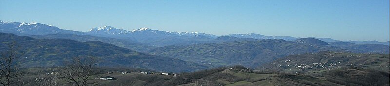
Sassuolo, located in the Emilia-Romagna region of northern Italy, is known for its beautiful landscapes, rich history, and vibrant ceramic industry. While Sassuolo itself is more urbanized, it serves as a gateway to various hiking opportunities in the surrounding areas, especially in the nearby Apennine mountains.
Popular Hiking Areas Near Sassuolo:
-
Parco Regionale dei Sassi di Roccamalatina:
- This regional park is famous for its unique rock formations and scenic views. There are various hiking trails ranging from easy to moderate difficulty, offering stunning vistas of the surrounding countryside. The trails often lead past ancient hermitages and provide opportunities for birdwatching.
-
Monte Cimino:
- Located further into the Apennines, this mountain offers trails that lead to panoramic viewpoints. The hike to the summit can be challenging but rewards you with breathtaking landscapes. The area is also rich in flora and fauna.
-
Civiltà dell’Appennino Trail:
- This trail offers a longer hike that connects various villages and natural sites around the Apennine mountains. It provides a great way to experience the local culture, food, and friendly communities along the path.
-
Frignano Park:
- A bit further away but accessible from Sassuolo, this park features diverse terrains and well-marked trails. Hikers can explore beautiful forests, rivers, and wildlife. It's a great place to experience the natural beauty of the region.
Tips for Hiking in Sassuolo and Surrounds:
- Preparation: Weather conditions can change quickly, especially in the mountains. Dress in layers and bring necessary gear, including sturdy hiking boots and plenty of water.
- Trail Maps: Make sure to carry a map or download a hiking app to help navigate the trails.
- Local Guidance: Consider hiring a local guide for more challenging hikes or if you're unfamiliar with the area. They can provide insights into the local flora, fauna, and history.
- Respect Nature: Follow Leave No Trace principles and respect local wildlife and vegetation.
Conclusion:
Whether you are a seasoned hiker or a beginner, the areas surrounding Sassuolo offer a fantastic range of hiking experiences. Be sure to soak in the natural beauty and cultural richness of this lesser-known yet captivating part of Italy!
- Страна:

- Почтовый код: 41049
- Телефонный код: 0536
- Код автомобильного номера: MO
- Координаты: 44° 33' 6" N, 10° 47' 8" E


- GPS треки (wikiloc): [Ссылка]
- Высота над уровнем моря: 121 м m
- Площадь: 38.4 кв.км
- Население: 40826
- Веб сайт: http://www.comune.sassuolo.mo.it
- Википедия русская: wiki(ru)
- Википедия английская: wiki(en)
- Википедия национальная: wiki(it)
- Хранилище Wikidata: Wikidata: Q8598
- Галерея изображений в википедии: [Ссылка]
- Катеория в википедии: [Ссылка]
- код Freebase: [/m/0clglb]
- код GeoNames: Альт: [6536733]
- код VIAF: Альт: [262574898]
- ID отношения в OpenStreetMap: [43229]
- идентификатор местоположения ArchINFORM: [4549]
- место в MusicBrainz: [95c7e23f-7346-4460-9b88-ede7f1925f64]
- код темы Quora: [Sassuolo]
- UN/LOCODE: [ITSSU]
- код ISTAT: 036040
- кадастровый код Италии: I462
Граничит с регионами:


Фьорано-Моденесе
- коммуна Италии
Hiking in Фьорано-Моденесе
Fiorano Modenese, located in the Emilia-Romagna region of Italy, is a charming area with beautiful landscapes and historical significance, making it a great destination for hiking enthusiasts. Here’s what you can expect when hiking in and around Fiorano Modenese:...
- Страна:
- Почтовый код: 41042
- Телефонный код: 0536
- Код автомобильного номера: MO
- Координаты: 44° 32' 21" N, 10° 48' 42" E
- GPS треки (wikiloc): [Ссылка]
- Высота над уровнем моря: 115 м m
- Площадь: 26.23 кв.км
- Население: 17099
- Веб сайт: [Ссылка]


Формиджине
- коммуна Италии
Hiking in Формиджине
Formigine, located in the Emilia-Romagna region of Italy, offers a variety of hiking opportunities that cater to different skill levels and preferences. Here are some highlights for hiking in and around Formigine:...
- Страна:
- Почтовый код: 41043
- Телефонный код: 059
- Код автомобильного номера: MO
- Координаты: 44° 34' 26" N, 10° 50' 52" E
- GPS треки (wikiloc): [Ссылка]
- Высота над уровнем моря: 82 м m
- Площадь: 46.74 кв.км
- Население: 34347
- Веб сайт: [Ссылка]

Приньяно-сулла-Секкья
- коммуна Италии
Hiking in Приньяно-сулла-Секкья
Prignano sulla Secchia is a picturesque village located in the Apennines region of northern Italy, particularly in the province of Modena. This area is known for its stunning natural beauty, with lush forests, rolling hills, and a variety of hiking trails suitable for all levels of hikers. Here are some things to consider when hiking in and around Prignano sulla Secchia:...
- Страна:
- Почтовый код: 41048
- Телефонный код: 0536
- Код автомобильного номера: MO
- Координаты: 44° 26' 13" N, 10° 41' 27" E
- GPS треки (wikiloc): [Ссылка]
- Высота над уровнем моря: 560 м m
- Площадь: 79.67 кв.км
- Население: 3766
- Веб сайт: [Ссылка]
Серрамаццони
- коммуна Италии
Hiking in Серрамаццони
Serramazzoni is a lovely town located in the Emilia-Romagna region of Italy, nestled in the Apennine Mountains. It offers a variety of hiking trails that cater to different skill levels and provide breathtaking views of the surrounding landscapes, including forests, hills, and valleys....
- Страна:
- Почтовый код: 41028
- Телефонный код: 0536
- Код автомобильного номера: MO
- Координаты: 44° 25' 0" N, 10° 48' 0" E
- GPS треки (wikiloc): [Ссылка]
- Высота над уровнем моря: 791 м m
- Площадь: 93.96 кв.км
- Население: 8304
- Веб сайт: [Ссылка]


Казальгранде
- коммуна Италии
Hiking in Казальгранде
Casalgrande is a small town located in the province of Reggio Emilia in northern Italy. While it may not be a widely recognized hiking destination, the surrounding region offers beautiful landscapes, especially in the Apennine Mountains and the Po Valley. Here are some points of interest and tips for hiking in and around Casalgrande:...
- Страна:
- Почтовый код: 42013
- Телефонный код: 0536; 0522
- Код автомобильного номера: RE
- Координаты: 44° 35' 23" N, 10° 44' 22" E
- GPS треки (wikiloc): [Ссылка]
- Высота над уровнем моря: 97 м m
- Площадь: 37.71 кв.км
- Население: 19234
- Веб сайт: [Ссылка]


Кастелларано
- коммуна Италии
Hiking in Кастелларано
Castellarano is a charming municipality located in the Emilia-Romagna region of Italy, surrounded by picturesque hills and natural beauty, making it an excellent destination for hiking enthusiasts. Here are some highlights and tips for hiking in and around Castellarano:...
- Страна:
- Почтовый код: 42014
- Телефонный код: 0536
- Код автомобильного номера: RE
- Координаты: 44° 30' 50" N, 10° 44' 2" E
- GPS треки (wikiloc): [Ссылка]
- Высота над уровнем моря: 149 м m
- Площадь: 58.06 кв.км
- Население: 15326
- Веб сайт: [Ссылка]