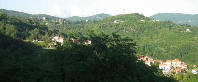
Савиньоне (Savignone, Savignone)
.svg)
- коммуна Италии
 Hiking in Савиньоне
Savignone, located in the Piedmont region of Italy, offers a variety of hiking opportunities that showcase the stunning natural landscapes and rich cultural heritage of the area. Here are some key points to consider if you're planning a hike in and around Savignone:
Trails and Routes
-
Natural Pathways: The area is part of the wider Apennine mountain range, providing a mix of trails suitable for different experience levels— from easy walks to more challenging hikes.
-
Cultural Trails: Some routes may lead you through historic villages, ancient ruins, or points of interest that reflect the local heritage. These paths are perfect for those looking to combine nature with history.
-
Local Parks: Nearby natural parks offer well-marked tracks and signage. Exploring these parks can reveal scenic views, diverse flora and fauna, and opportunities for wildlife spotting.
What to Expect
- Scenic Views: Expect panoramic views of the Apennines and lush valleys. The changing seasons bring vibrant colors to the landscapes, especially in the spring and fall.
- Wildlife and Flora: The region's biodiversity makes it a great spot for nature enthusiasts. Keep an eye out for various birds, mammals, and plant species.
Practical Information
-
Weather Considerations: Always check the weather before your hike. The best seasons for hiking in this area are typically spring and early autumn when temperatures are mild.
-
Gear: Proper hiking gear including sturdy footwear, clothing suitable for changing weather, a hat, sunscreen, and sufficient water is advisable.
-
Local Guidance: If you're unfamiliar with the area, consider hiring a local guide who can provide insights into the trails and their significance.
Safety Tips
- Stay on Marked Trails: To preserve the environment and ensure your safety, stick to marked paths.
- Group Hiking: It’s often best to hike with a partner or group, especially in more remote areas.
Conclusion
Hiking in Savignone can be a rewarding experience for both casual walkers and seasoned hikers. Whether you are looking for a peaceful day in nature or an adventurous trek, the diverse offerings around Savignone cater to all interests and skill levels. Enjoy your hike!
- Страна:

- Почтовый код: 16010
- Телефонный код: 010
- Код автомобильного номера: GE
- Координаты: 44° 33' 50" N, 8° 59' 19" E


- GPS треки (wikiloc): [Ссылка]
- Высота над уровнем моря: 500 м m
- Площадь: 21.74 кв.км
- Население: 3112
- Веб сайт: http://www.comune.savignone.ge.it
- Википедия русская: wiki(ru)
- Википедия английская: wiki(en)
- Википедия национальная: wiki(it)
- Хранилище Wikidata: Wikidata: Q265708
- Катеория в википедии: [Ссылка]
- код Freebase: [/m/0ghwxc]
- код GeoNames: Альт: [6543075]
- код VIAF: Альт: [136208356]
- ID отношения в OpenStreetMap: [43276]
- UN/LOCODE: [ITSAV]
- код ISTAT: 010057
- кадастровый код Италии: I475
Граничит с регионами:

Миньянего
- коммуна Италии
Hiking in Миньянего
Mignanego, located in the Liguria region of Italy, is a charming area that offers a variety of hiking opportunities for nature enthusiasts and outdoor adventurers. Here are some key highlights about hiking in Mignanego:...
- Страна:
- Почтовый код: 16018
- Телефонный код: 010
- Код автомобильного номера: GE
- Координаты: 44° 31' 40" N, 8° 54' 55" E
- GPS треки (wikiloc): [Ссылка]
- Высота над уровнем моря: 150 м m
- Площадь: 16.27 кв.км
- Население: 3607
- Веб сайт: [Ссылка]


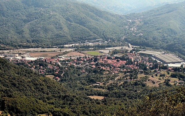
Серра-Рикко
- коммуна Италии
Hiking in Серра-Рикко
Serra Riccò is a picturesque municipality located in the Liguria region of Italy, near the city of Genoa. The area is characterized by its rolling hills, lush greenery, and breathtaking views, making it a charming destination for hikers and outdoor enthusiasts....
- Страна:
- Почтовый код: 16010
- Телефонный код: 010
- Код автомобильного номера: GE
- Координаты: 44° 30' 28" N, 8° 56' 9" E
- GPS треки (wikiloc): [Ссылка]
- Высота над уровнем моря: 187 м m
- Площадь: 26.2 кв.км
- Население: 7826
- Веб сайт: [Ссылка]


Бузалла
- коммуна Италии
Hiking in Бузалла
Busalla is a charming town in the province of Genoa, Italy, surrounded by beautiful landscapes that offer a range of hiking opportunities. The area is characterized by its lush greenery, rolling hills, and stunning views of the surrounding Apennines. Here’s what you need to know about hiking in and around Busalla:...
- Страна:
- Почтовый код: 16012
- Телефонный код: 010
- Код автомобильного номера: GE
- Координаты: 44° 34' 16" N, 8° 56' 43" E
- GPS треки (wikiloc): [Ссылка]
- Высота над уровнем моря: 358 м m
- Площадь: 17.06 кв.км
- Население: 5545
- Веб сайт: [Ссылка]

Казелла
- коммуна Италии
Hiking in Казелла
Casella, located in the Liguria region of Italy, offers beautiful hiking opportunities with its stunning landscapes and rich natural diversity. Here’s what you need to know about hiking in and around Casella:...
- Страна:
- Почтовый код: 16015
- Телефонный код: 010
- Код автомобильного номера: GE
- Координаты: 44° 32' 5" N, 8° 59' 56" E
- GPS треки (wikiloc): [Ссылка]
- Высота над уровнем моря: 410 м m
- Площадь: 8.07 кв.км
- Население: 3136
- Веб сайт: [Ссылка]


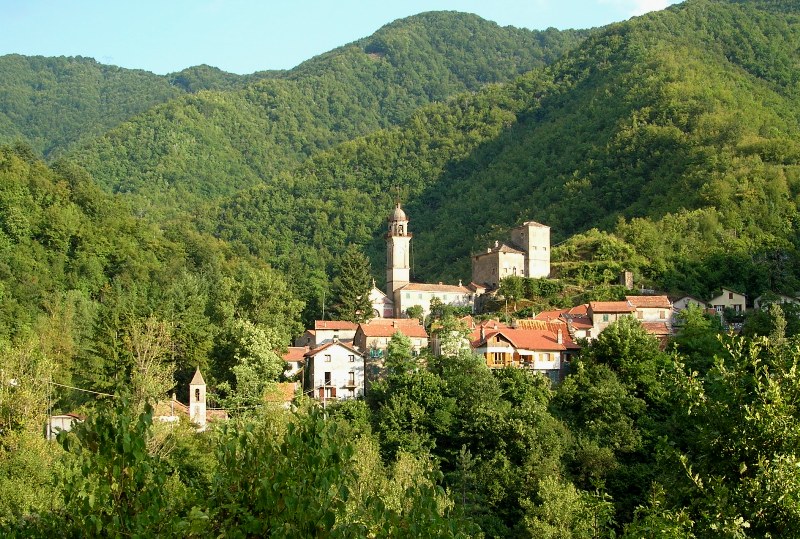
Крочефиески
- коммуна Италии
Hiking in Крочефиески
Crocefieschi is a small town located in the Liguria region of Italy, nestled in the Apennine Mountains. This area can be a delightful destination for those looking to experience hiking amidst picturesque landscapes, rich biodiversity, and charming villages. Here are some key aspects to consider if you're planning to hike in Crocefieschi:...
- Страна:
- Почтовый код: 16010
- Телефонный код: 010
- Код автомобильного номера: GE
- Координаты: 44° 35' 5" N, 9° 1' 24" E
- GPS треки (wikiloc): [Ссылка]
- Высота над уровнем моря: 742 м m
- Площадь: 11.73 кв.км
- Население: 541
- Веб сайт: [Ссылка]

Вальбревенна
- коммуна Италии
Hiking in Вальбревенна
Valbrevenna is a beautiful valley located in the Liguria region of Italy, known for its picturesque landscapes, historical villages, and scenic hiking trails. The area is less commercialized than some other parts of Liguria, making it ideal for those seeking a more tranquil hiking experience....
- Страна:
- Почтовый код: 16010
- Телефонный код: 010
- Код автомобильного номера: GE
- Координаты: 44° 33' 58" N, 9° 3' 48" E
- GPS треки (wikiloc): [Ссылка]
- Высота над уровнем моря: 533 м m
- Площадь: 34.67 кв.км
- Население: 788
- Веб сайт: [Ссылка]