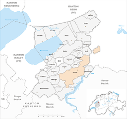
See District (Seebezirk)

 Hiking in See District
The See District in Fribourg, Switzerland, offers a stunning backdrop for hiking enthusiasts. Nestled in the heart of Switzerland, this region is known for its picturesque landscapes, rolling hills, and serene lakes, making it ideal for outdoor activities.
Hiking Trails
-
Lake Murten: This is a popular area for both walking and hiking. The trail around the lake offers beautiful views and is accessible for all skill levels. You can enjoy the tranquil waters, quaint towns like Murten, and historical sites along the way.
-
The Gruyère Region: Although technically just beyond the See District, many hikers venture here for its famous cheese region. Trails here offer breathtaking views of the Alps and lush green pastures. The hike from Bulle to Château de Gruyères is particularly favored.
-
The Sense River: Trails along the Sense River are perfect for those who enjoy more gentle hikes. The paths are often shaded, making it a refreshing option on warmer days.
-
Murten to Avenches: This route provides a combination of cultural experiences with historical Roman ruins in Avenches and beautiful scenery along the way.
Difficulty Levels
The See District features a range of trails, from easy lakeside walks to more challenging hikes in the surrounding hills. Always check the difficulty rating of your chosen trail and prepare accordingly.
Best Times to Hike
- Spring (April to June): Enjoy wildflowers and moderate temperatures.
- Summer (June to August): Longer days provide ample time to explore, but be prepared for warmer conditions. Hydration is key!
- Fall (September to October): Experience beautiful foliage and fewer crowds.
- Winter: Some trails remain accessible for snowshoeing and winter hiking, but always check local conditions.
Preparation
- Gear: Depending on the season, sturdy hiking boots, weather-appropriate clothing, and plenty of water are essential.
- Map or GPS: While many trails are well-marked, having a map or GPS can help keep you on track.
- Safety: Inform someone of your hiking plans, especially if you’re venturing into less-populated areas.
Local Attractions
- Historical Sites: Explore the medieval town of Murten, or visit Avenches for its Roman ruins.
- Gastronomy: Don’t miss the opportunity to sample local Swiss cheese and chocolates in the area.
The See District is perfect for a day hike or a longer trekking adventure, with its blend of nature, history, and Swiss culture. Enjoy your hiking experience!
- Страна:

- Столица: Муртен
- Код автомобильного номера: FR
- Координаты: 46° 54' 37" N, 7° 8' 27" E


- GPS треки (wikiloc): [Ссылка]
- Высота над уровнем моря: 540 м m
- Площадь: 142.1 кв.км
- Веб сайт: http://www.fr.ch/pref/de/pub/pla/index.cfm
- Википедия английская: wiki(en)
- Википедия национальная: wiki(de)
- Хранилище Wikidata: Wikidata: Q659778
- код Freebase: [/m/026xyj9]
- код GeoNames: Альт: [6458820]
- ID отношения в OpenStreetMap: [1699156]
- код GND: Альт: [4054085-6]
- идентификатор HDS: [8157]
Включает регионы:

Gurmels
Hiking in Gurmels
Gurmels is a charming municipality in the canton of Fribourg, Switzerland, located near the picturesque region of Lake Murten. The area is known for its beautiful landscapes, rolling hills, and diverse trails that cater to hikers of all levels....
- Страна:
- Почтовый код: 3212
- Телефонный код: 026
- Код автомобильного номера: FR
- Координаты: 46° 54' 0" N, 7° 10' 0" E
- GPS треки (wikiloc): [Ссылка]
- Высота над уровнем моря: 542 м m
- Площадь: 17.21 кв.км
- Население: 4287
- Веб сайт: [Ссылка]


Barberêche
Hiking in Barberêche
Barberêche, located in the canton of Fribourg in Switzerland, is a beautiful area known for its picturesque landscapes and outdoor activities. While it may not be as popular as some of the larger hiking destinations in the Swiss Alps, it offers a variety of trails and opportunities for hiking enthusiasts....
- Страна:
- Телефонный код: 026
- Код автомобильного номера: FR
- Координаты: 46° 51' 0" N, 7° 10' 0" E
- GPS треки (wikiloc): [Ссылка]
- Высота над уровнем моря: 569 м m
- Площадь: 9.13 кв.км
- Веб сайт: [Ссылка]


Courlevon
Hiking in Courlevon
Courlevon is a charming area located in the southwestern part of Switzerland, known for its picturesque landscapes and outdoor activities, including hiking. Here are some key aspects to consider if you're thinking about hiking in Courlevon:...
- Страна:
- Почтовый код: 1795
- Телефонный код: 026
- Код автомобильного номера: FR
- Координаты: 46° 53' 0" N, 7° 7' 0" E
- GPS треки (wikiloc): [Ссылка]
- Высота над уровнем моря: 556 м m
- Площадь: 3.27 кв.км
- Веб сайт: [Ссылка]
Misery-Courtion
Hiking in Misery-Courtion
Hiking in Misery-Courtion, located in the French region of Normandy, often offers a unique blend of scenic beauty and challenging terrain. Here’s what you might consider when planning a hike in that area:...
- Страна:
- Почтовый код: 1721
- Телефонный код: 026
- Код автомобильного номера: FR
- Координаты: 46° 51' 0" N, 7° 4' 0" E
- GPS треки (wikiloc): [Ссылка]
- Высота над уровнем моря: 580 м m
- Площадь: 11.42 кв.км
- Население: 1958
- Веб сайт: [Ссылка]


Ulmiz
Hiking in Ulmiz
Ulmiz is a picturesque village located in the canton of Fribourg in Switzerland, known for its stunning landscapes and access to the scenic terrain of the Swiss Alps. When planning a hiking trip in Ulmiz, here are some key points to consider:...
- Страна:
- Почтовый код: 3214
- Телефонный код: 031
- Код автомобильного номера: FR
- Координаты: 46° 56' 0" N, 7° 12' 0" E
- GPS треки (wikiloc): [Ссылка]
- Высота над уровнем моря: 494 м m
- Площадь: 2.86 кв.км
- Население: 438
- Веб сайт: [Ссылка]


Гальмиц
- община в Швейцарии
Hiking in Гальмиц
Galmiz, a small area in Switzerland near the city of Fribourg, offers a beautiful backdrop for hiking enthusiasts. The region is known for its picturesque landscapes, rolling hills, and charming rural scenery....
- Страна:
- Почтовый код: 3285
- Телефонный код: 026
- Код автомобильного номера: FR
- Координаты: 46° 57' 0" N, 7° 9' 0" E
- GPS треки (wikiloc): [Ссылка]
- Высота над уровнем моря: 441 м m
- Площадь: 8.92 кв.км
- Население: 672
- Веб сайт: [Ссылка]
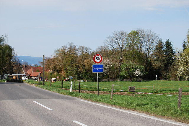

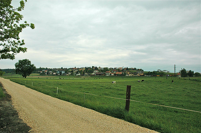
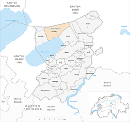
Courgevaux
Hiking in Courgevaux
Courgevaux is a charming village located in the Canton of Fribourg, Switzerland. It offers a great opportunity for hiking enthusiasts to explore the beautiful Swiss countryside. The area is known for its picturesque landscapes, rolling hills, lush forests, and well-maintained trails....
- Страна:
- Почтовый код: 1796
- Телефонный код: 026
- Код автомобильного номера: FR
- Координаты: 46° 54' 0" N, 7° 7' 0" E
- GPS треки (wikiloc): [Ссылка]
- Высота над уровнем моря: 475 м m
- Площадь: 3.39 кв.км
- Население: 1424
- Веб сайт: [Ссылка]


Wallenried
Hiking in Wallenried
Wallenried is a picturesque village located in the canton of Fribourg, Switzerland, near the shores of Lake Murten. While it may not be as widely recognized as some of the larger hiking destinations in Switzerland, it offers charming trails and beautiful natural landscapes that can be great for a day outing or a weekend hike....
- Страна:
- Почтовый код: 1784
- Телефонный код: 026
- Код автомобильного номера: FR
- Координаты: 46° 52' 0" N, 7° 7' 0" E
- GPS треки (wikiloc): [Ссылка]
- Высота над уровнем моря: 559 м m
- Площадь: 3.88 кв.км
- Веб сайт: [Ссылка]


Муртен
Hiking in Муртен
Murten, located in the canton of Fribourg in Switzerland, offers a picturesque setting for hiking enthusiasts. This charming town is situated on the shores of Lake Murten and is surrounded by beautiful landscapes, including vineyards, rolling hills, and forests. Here are some highlights and tips for hiking in the Murten area:...
- Страна:
- Почтовый код: 3280
- Телефонный код: 026
- Код автомобильного номера: FR
- Координаты: 46° 55' 41" N, 7° 7' 1" E
- GPS треки (wikiloc): [Ссылка]
- Высота над уровнем моря: 453 м m
- Площадь: 12.02 кв.км
- Население: 8222
- Веб сайт: [Ссылка]


Haut-Vully
Hiking in Haut-Vully
Haut-Vully, located in the canton of Fribourg in Switzerland, is a picturesque region that offers a delightful mixture of rolling hills, vineyards, and stunning views of Lake Murten and the surrounding countryside. Here’s some information to help you make the most of your hiking experience there:...
- Страна:
- Почтовый код: 1787, 1789
- Телефонный код: 026
- Код автомобильного номера: FR
- Координаты: 46° 57' 0" N, 7° 5' 0" E
- GPS треки (wikiloc): [Ссылка]
- Высота над уровнем моря: 434 м m
- Площадь: 7.47 кв.км
- Веб сайт: [Ссылка]


Jeuss
Hiking in Jeuss
It seems that there might be a typo in your request regarding "Jeuss." If you're referring to a specific hiking location or area, please clarify so I can provide accurate information....
- Страна:
- Почтовый код: 1793
- Телефонный код: 026
- Код автомобильного номера: FR
- Координаты: 46° 54' 0" N, 7° 10' 0" E
- GPS треки (wikiloc): [Ссылка]
- Высота над уровнем моря: 544 м m
- Площадь: 1.77 кв.км
- Веб сайт: [Ссылка]

Cressier
Hiking in Cressier
Cressier, located in the Fribourg region of Switzerland, offers a variety of hiking opportunities that showcase the natural beauty of the area. Here are some highlights and tips for hiking in Cressier:...
- Страна:
- Почтовый код: 1785
- Телефонный код: 026
- Код автомобильного номера: FR
- Координаты: 46° 54' 0" N, 7° 8' 0" E
- GPS треки (wikiloc): [Ссылка]
- Высота над уровнем моря: 569 м m
- Площадь: 4.16 кв.км
- Население: 957
- Веб сайт: [Ссылка]


Fräschels
Hiking in Fräschels
Fräschels, located in the canton of Fribourg in Switzerland, is a charming village nestled among rolling hills and verdant landscapes, making it an excellent destination for hiking enthusiasts. The area is characterized by its scenic trails that offer a mix of gentle walks suitable for families as well as more challenging routes for experienced hikers....
- Страна:
- Почтовый код: 3284
- Телефонный код: 031
- Код автомобильного номера: FR
- Координаты: 47° 0' 0" N, 7° 12' 0" E
- GPS треки (wikiloc): [Ссылка]
- Высота над уровнем моря: 457 м m
- Площадь: 3.14 кв.км
- Население: 467
- Веб сайт: [Ссылка]
Meyriez
Hiking in Meyriez
Meyriez is a charming village located near the shores of Lake Murten in the Canton of Fribourg, Switzerland. It offers a picturesque setting for hiking enthusiasts looking to explore the beautiful Swiss countryside. Here are some key points to consider when hiking in Meyriez:...
- Страна:
- Почтовый код: 3280
- Телефонный код: 026
- Код автомобильного номера: FR
- Координаты: 46° 55' 0" N, 7° 7' 0" E
- GPS треки (wikiloc): [Ссылка]
- Высота над уровнем моря: 435 м m
- Площадь: 0.32 кв.км
- Население: 575
- Веб сайт: [Ссылка]


Muntelier
Hiking in Muntelier
Muntelier, located in the Canton of Fribourg in Switzerland, is a beautiful area that offers scenic views and great hiking opportunities, particularly around the shores of Lake Murten. The region is characterized by its charming landscapes, including lush meadows, vineyards, and rolling hills. Here’s what you can expect when hiking in Muntelier:...
- Страна:
- Почтовый код: 3286
- Телефонный код: 026
- Код автомобильного номера: FR
- Координаты: 46° 56' 0" N, 7° 7' 0" E
- GPS треки (wikiloc): [Ссылка]
- Высота над уровнем моря: 435 м m
- Площадь: 1.13 кв.км
- Население: 972
- Веб сайт: [Ссылка]


Kerzers
Hiking in Kerzers
Kerzers, located in the canton of Fribourg in Switzerland, offers a charming experience for hikers with its picturesque landscapes, scenic trails, and proximity to the beautiful Lake Murten. The region is characterized by gentle rolling hills, lush forests, meadows, and stunning views of the surrounding Alps....
- Страна:
- Почтовый код: 3210
- Телефонный код: 031
- Код автомобильного номера: FR
- Координаты: 46° 59' 0" N, 7° 12' 0" E
- GPS треки (wikiloc): [Ссылка]
- Высота над уровнем моря: 450 м m
- Площадь: 12.0 кв.км
- Население: 5020
- Веб сайт: [Ссылка]
Greng
Hiking in Greng
It seems there might be a typo in your query. If you meant to ask about a specific location, such as "Glen" or a particular hiking area or park, please let me know....
- Страна:
- Почтовый код: 3280
- Телефонный код: 026
- Код автомобильного номера: FR
- Координаты: 46° 55' 0" N, 7° 6' 0" E
- GPS треки (wikiloc): [Ссылка]
- Высота над уровнем моря: 439 м m
- Площадь: 1.01 кв.км
- Население: 175
- Веб сайт: [Ссылка]
Lurtigen
Hiking in Lurtigen
Lurtigen is not widely recognized in mainstream hiking guides but could be a local or lesser-known destination. If you're considering hiking in Lurtigen, here's a general approach to ensure a great experience:...
- Страна:
- Почтовый код: 3215
- Телефонный код: 031
- Код автомобильного номера: FR
- Координаты: 46° 56' 0" N, 7° 10' 0" E
- GPS треки (wikiloc): [Ссылка]
- Высота над уровнем моря: 567 м m
- Площадь: 2.30 кв.км
- Веб сайт: [Ссылка]

Bas-Vully
Hiking in Bas-Vully
Bas-Vully is a beautiful region located in Switzerland, known for its stunning landscapes, vineyards, and the picturesque Lake Murten. Hiking in Bas-Vully offers various trails suitable for different skill levels, making it an excellent destination for both beginner and experienced hikers....
- Страна:
- Телефонный код: 026
- Код автомобильного номера: FR
- Координаты: 46° 58' 0" N, 7° 7' 0" E
- GPS треки (wikiloc): [Ссылка]
- Высота над уровнем моря: 433 м m
- Площадь: 9.95 кв.км
- Веб сайт: [Ссылка]


Salvenach
Hiking in Salvenach
Salvenach is a lovely region, often associated with beautiful landscapes, mountain vistas, and serene nature trails. While it might not be as widely recognized as some other hiking destinations, it offers a peaceful hiking experience, ideal for both novice and experienced hikers....
- Страна:
- Почтовый код: 1794
- Телефонный код: 026
- Код автомобильного номера: FR
- Координаты: 46° 55' 0" N, 7° 9' 0" E
- GPS треки (wikiloc): [Ссылка]
- Высота над уровнем моря: 561 м m
- Площадь: 3.85 кв.км
- Веб сайт: [Ссылка]


Kleinbösingen
Hiking in Kleinbösingen
Kleinbösingen, a charming village in the canton of Fribourg, Switzerland, offers a variety of hiking opportunities that showcase the beautiful Swiss landscape. The area is characterized by its rolling hills, lush meadows, and picturesque views, making it an inviting destination for hikers of all skill levels....
- Страна:
- Почтовый код: 3213
- Телефонный код: 026
- Код автомобильного номера: FR
- Координаты: 46° 54' 0" N, 7° 12' 0" E
- GPS треки (wikiloc): [Ссылка]
- Высота над уровнем моря: 509 м m
- Площадь: 3.01 кв.км
- Население: 654
- Веб сайт: [Ссылка]


Gempenach
Hiking in Gempenach
Gempenach, a small village in Switzerland, is surrounded by beautiful natural landscapes, making it an excellent spot for hiking enthusiasts. The region offers a variety of trails that cater to different skill levels, from gentle walks suitable for families to more challenging hikes for experienced trekkers....
- Страна:
- Почтовый код: 3215
- Телефонный код: 031
- Код автомобильного номера: FR
- Координаты: 46° 56' 0" N, 7° 12' 0" E
- GPS треки (wikiloc): [Ссылка]
- Высота над уровнем моря: 501 м m
- Площадь: 1.66 кв.км
- Население: 291
- Веб сайт: [Ссылка]


Ried bei Kerzers
Hiking in Ried bei Kerzers
Ried bei Kerzers, located in the Swiss canton of Fribourg, is a charming area known for its picturesque landscapes and accessibility to outdoor activities, including hiking. The region is characterized by its rolling hills, lush fields, and extensive wetlands, making it an excellent destination for nature lovers and hikers....
- Страна:
- Почтовый код: 3216
- Телефонный код: 031
- Код автомобильного номера: FR
- Координаты: 46° 57' 48" N, 7° 10' 52" E
- GPS треки (wikiloc): [Ссылка]
- Высота над уровнем моря: 438 м m
- Площадь: 7.57 кв.км
- Население: 1185
- Веб сайт: [Ссылка]
Villarepos
Hiking in Villarepos
Villarepos, located in the Swiss region of Fribourg, is a charming village surrounded by beautiful landscapes that are ideal for hiking enthusiasts. Here’s what you can expect when hiking in Villarepos:...
- Страна:
- Почтовый код: 1583
- Телефонный код: 026
- Код автомобильного номера: FR
- Координаты: 46° 52' 56" N, 7° 4' 48" E
- GPS треки (wikiloc): [Ссылка]
- Высота над уровнем моря: 469 м m
- Площадь: 4.74 кв.км
- Веб сайт: [Ссылка]


Courtepin
Hiking in Courtepin
Courtepin, a picturesque municipality located in the Canton of Fribourg, Switzerland, offers a variety of hiking opportunities for outdoor enthusiasts. The region is characterized by its stunning landscapes, rolling hills, and charming rural surroundings, making it an ideal spot for hikers of all skill levels....
- Страна:
- Телефонный код: 026
- Координаты: 46° 52' 0" N, 7° 7' 0" E
- GPS треки (wikiloc): [Ссылка]
- Высота над уровнем моря: 578 м m
- Площадь: 4.08 кв.км
- Население: 5416
- Веб сайт: [Ссылка]